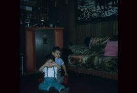
Mostrar 482 resultados

Archival description
482 resultados com objetos digitais Mostrar resultados com objetos digitais
Sprawl
2012.13.1.3.026 · Item · Oct. 1975
Parte de J. Kent Sedgwick fonds

Image depicts a few houses, most likely near the airport in Prince George, B.C.

Spruceland
2012.13.1.5.24 · Item · Mar. 2003
Parte de J. Kent Sedgwick fonds

Image depicts a Lakewood view of Spruceland in Prince George, B.C.

Start of Birchleg
2012.13.1.129.04 · Item · 1975
Parte de J. Kent Sedgwick fonds

Image depicts a long line of people cross country skiing along the Birchleg route on Tabor Mountain in Prince George, B.C.

Storage Sheds
2012.13.1.7.235 · Item · Mar. 2003
Parte de J. Kent Sedgwick fonds

Image depicts a few storage sheds somewhere in Prince George, B.C.

Studio 2880 Arts Complex
2012.13.1.3.170 · Item · Apr. 2003
Parte de J. Kent Sedgwick fonds

Image depicts Studio 2880 Arts Complex in Prince George, B.C. Map coordinates 53°54'36.9"N 122°46'30.3"W

Studio 2880 Arts Complex
2012.13.1.7.245 · Item · Mar. 2003
Parte de J. Kent Sedgwick fonds

Image depicts a building which is a part of the Studio 2880 Arts Complex on 15th Avenue in Prince George, B.C.

Suspended Trailer
2012.13.1.122.09 · Item · Oct. 1975
Parte de J. Kent Sedgwick fonds

Image depicts a trailer for a logging truck suspended off the ground by a wooden structure. This is used to load the trailer onto the back of the truck. The name on the truck says "Rormarniewich Trucking Ltd."

Tabor Grooves
2012.13.1.124.24 · Item · [1976?]
Parte de J. Kent Sedgwick fonds

Image depicts grooves on Tabor Mountain in Prince George, B.C.

Tabor Grooving
2012.13.1.124.23 · Item · March 1976
Parte de J. Kent Sedgwick fonds

Image depicts grooving on Tabor Mountain in Prince George, B.C.

Tabor Mountain
2012.13.1.129.11 · Item · 1975
Parte de J. Kent Sedgwick fonds

Image depicts a view of the area around Tabor Mountain in Prince George, B.C.

Tabor Mountain
2012.13.1.126.11 · Item · 1975
Parte de J. Kent Sedgwick fonds

Image depicts Tabor Mountain in the distance, located in Prince George, B.C.

Tabor Mountain
2012.13.1.129.10 · Item · 1975
Parte de J. Kent Sedgwick fonds

Image depicts a view of the area around Tabor Mountain in Prince George, B.C.

Tabor Mountain
2012.13.1.3.028 · Item · Oct. 1975
Parte de J. Kent Sedgwick fonds

Image depicts Tabor Mountain from the airport in Prince George, B.C.

Tabor Mountain
2012.13.1.3.068 · Item · Nov. 1979
Parte de J. Kent Sedgwick fonds

Image depicts a view of Prince George, from Gunn Point in the L.C. Gunn Park.

Tabor View
2012.13.1.3.003 · Item · Oct. 1970
Parte de J. Kent Sedgwick fonds

Image depicts a view of Tabor Mountain in Prince George, B.C.

Third Avenue
2012.13.1.3.161 · Item · May 2001
Parte de J. Kent Sedgwick fonds

Image depicts 3rd Ave in Prince George, B.C. Map coordinates 53°55'01.9"N 122°44'48.7"W

Tractor with Logs
2012.13.1.122.16 · Item · [1979?]
Parte de J. Kent Sedgwick fonds

Image depicts a tractor with a claw lifting logs at a saw mill in Prince George, B.C.

Trailer Park
2012.13.1.5.27 · Item · Mar. 2003
Parte de J. Kent Sedgwick fonds

Image depicts a trailer park by either the Fraser or Nechako River in Prince George, B.C.

Trailers for Sale
2012.13.1.3.027 · Item · Oct. 1975
Parte de J. Kent Sedgwick fonds

Image depicts mobile homes for sale on Cowart Road looking northeast with Simon Fraser Bridge in background. Map coordinates 53°52'39.3"N 122°46'13.1"W

Train Fuelling Station
2012.13.1.19.02 · Item · 1979
Parte de J. Kent Sedgwick fonds

Image depicts what is possibly a train fuelling station at the GTP Roundhouse in Prince George, B.C.

Train Fuelling Station
2012.13.1.19.03 · Item · 1979
Parte de J. Kent Sedgwick fonds

Image depicts what is possibly a train fuelling station at the GTP Roundhouse in Prince George, B.C.

Train Fuelling Station
2012.13.1.19.04 · Item · 1979
Parte de J. Kent Sedgwick fonds

Image depicts what is possibly a train fueling station at the GTP Roundhouse in Prince George, B.C.

Train with Logs
2012.13.1.122.08 · Item · Oct. 1975
Parte de J. Kent Sedgwick fonds

Image depicts a train carrying logs somewhere in Prince George, B.c.

Trains and People
2012.13.1.19.07 · Item · 1979
Parte de J. Kent Sedgwick fonds

Image depicts a train and a group of unknown individuals at the GTP roundhouse in Prince George, B.C.

Tree Cutter
2012.13.1.122.26 · Item · May 1980
Parte de J. Kent Sedgwick fonds

Image depicts two unidentified individuals examining a thick log still attached to the machine that cut it down. It is located somewhere in Prince George, B.C.

Troll Lake Cabin
2012.13.1.129.12 · Item · 1975
Parte de J. Kent Sedgwick fonds

Image depicts numerous skiers at the cabin located at Troll Lake on Tabor Mountain in Prince George, B.C.

Two Children
2012.13.1.22.15 · Item · 1970
Parte de J. Kent Sedgwick fonds

Image depicts two unknown children in a house somewhere in Island Cache.

Varves
2012.13.1.124.16 · Item · Oct. 1975
Parte de J. Kent Sedgwick fonds

Image depicts an example of varves, an annual layer of sediment or rock, with a pipe used for reference size. It is possibly located at the airport in Prince George, B.C.

Varves
2012.13.1.124.15 · Item · Oct. 1975
Parte de J. Kent Sedgwick fonds

Image depicts an example of varves, an annual layer of sediment or rock, possibly located at the airport in Prince George, B.C.

Veteran House
2012.13.1.24.36 · Item · 2000
Parte de J. Kent Sedgwick fonds

Image depicts a property given to the Veterans of the Second World War, located on the corner of 15th Avenue and Elm Street in Prince George, B.C.