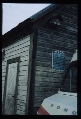
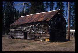
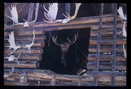
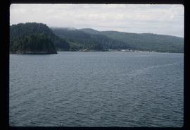
Image depicts a boat named "the Tarahne," which is located in Atlin, B.C. Atlin Lake and Mountain are visible in the background.
Image depicts the Garrett Store in Atlin, B.C. A plaque on it reads: "John Garrett, a prominent English cricket player, came to Atlin in 1910 to mine gold. In 1917 he opened this grocery and dry goods store where he also sold his wife's fresh baked bread and sweets."
Image depicts a pyramid shaped house, possibly located in Atlin, B.C.
Image depicts the post office in Atlin, B.C.
Image depicts old machinery, at the Atlin Museum in Atlin, B.C.
Image depicts an old boat on the shore of Atlin Lake.
Image depicts a building which once served as the residence for two nurses in Atlin, B.C. A sign in front of the house reads: "Grateful Atlinites built this house in 1902 for their first missionary nurses, Helen Bone and Elizabeth Mitchell, who came here in 1899 and lived in a crude shack while valiantly and humanely caring for sick and dying pioneers."
Image depicts a mural of Atlin with information about the Globe Theatre and Edwin L. Pillman on it. It reads: "Talented businessman arrived in Atlin in 1899, and for nearly fifty years operated a variety of businesses ~ grocery and drug stores, undertaker, market gardens and the theatre. Assissted by his loyal wife Elizabeth." It also states that the Globe Theatre was built in 1917 and was used until the early 40's.
Image depicts numerous old buildings on a main street in Atlin, B.C.
Image depicts the government liquor store in Atlin, B.C.
Image depicts a house with stairs up to a small patio area on its roof in Atlin, B.C.
Image depicts the Globe Theatre in Atlin, B.C.
Image depicts the fire hall in Atlin, B.C.
Image depicts an old building which used to be the Discovery Jail. The plaque on it reads: "It cost $800 to build this two cell jail in 1902. The solid walls are 2"x6" laid flat one on top of the other. It was skidded to Atlin in the 1920s and used as a residence for many years."
Image depicts an old building undergoing a restoration process, possibly in Atlin, B.C.
Image depicts a back street in Atlin, B.C.
Image depicts a dock on the shore of Atlin Lake, as well as a building that may have once been a hospital. The slide is simply labelled "hospital."
Image depicts Ash Street and Patricia Boulevard in Prince George, B.C.
Image depicts the Aquatic Centre in Prince George, B.C.
Image depicts numerous buildings on the shore of Haida Gwaii as the ferry approaches.
Image depicts an apartment building in Tumbler Ridge, B.C.
Image depicts what appears to be an apartment building among several others in an uncertain location.
Image depicts a wood cabin with antlers somewhere in Mud River, B.C.
Image depicts a wood cabin with antlers and a moose head somewhere in Mud River, B.C.
Image depicts another train on the White Pass railway along a forested mountain side.
Image depicts a group of people in Cottonwood Park with an individual, possibly former mayor Elmer Mercier, making an announcement.
Image depicts what appears to be an animal pen in Island Cache. There is a goat and numerous chickens in the image, as well as a pile of miscellaneous material.
Image depicts what appears to be an animal pen in Island Cache. There are two horses and a chicken in the enclosure, and a rundown building.
Image depicts a view of D'Arcy, located on the southern end of Anderson Lake.
Image depicts a vehicle on a bridge somewhere near Anderson Lake in the Seton Portage area.
Image depicts power lines running alongside Anderson Lake near Seton Portage, B.C.
Image depicts the Anderson Lake.
Image depicts a view of Anderson Lake near Seton Portage, B.C. A vehicle on a mountain road is also visible.
Image depicts a view of Anderson Lake near Seton Portage, B.C.
Image depicts an old, rundown building at an uncertain location.
Image depicts the Alkali Lake Ranch in Alkali Lake, B.C.
Image depicts the Alkali Lake Ranch in Akali Lake, B.C.
Image depicts the Alkali Lake Ranch in Alkali Lake, B.C.
Image depicts an old beer advertisement for Alexandria Lager, somewhere in Wells, B.C.
Image depicts some farmland near Alexandria, B.C.
Image depicts the Alcan smelter in Kitimat, B.C.
Image depicts a small section of the Alaska Highway somewhere near Whitehorse, Y.T. The slide also appears to be labelled "army washing" for unknown reasons.
Image depicts the ferry to Alaska in the port of Prince Rupert, B.C.
Image depicts the interior of an old convenience store; there are several unknown individuals present. It is located at the 153 Mile House.
Image depicts the interior of an old convenience store; numerous unknown individuals are present. It is located at the 153 Mile House.
Image depicts an old convenience store, with a sign on it labelled "Al Crosina." It is located at the 153 Mile House.
Image depicts a marker for aerial photography at an uncertain location. The slide labels it as "Elizabeth Station."