Aperçu avant impression Fermer

Affichage de 2383 résultats

Archival description
1595 résultats avec objets numériques Afficher les résultats avec des objets numériques
The Bay, 1303 3rd Avenue, Prince George
2012.13.3.1.11.110 · Pièce · [1978 or 1979]
Fait partie de J. Kent Sedgwick fonds

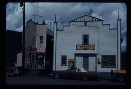
The item is a photograph depicting the exterior view of the front of The Bay at 1303 3rd Avenue, Prince George. There is a black Toyota pickup parked out front. There is a man walking in front of the business. Photograph originally taken between 1978 and 1979.

Terzaghi Dam on the Bridge River
2012.13.1.59.01 · Pièce · July 1980
Fait partie de J. Kent Sedgwick fonds

Image depicts the Terzaghi Dam on the Bridge River, looking from the upstream (reservoir) side located near Bralorne, B.C. The water is Carpenter Lake.

Terzaghi Dam
2012.13.1.59.22 · Pièce · July 1980
Fait partie de J. Kent Sedgwick fonds

Image depicts the Terzaghi Dam viewed from the downstream side near Bralorne B.C.

Teepee?
2012.13.1.87.037 · Pièce · [between 1975 and 1995]
Fait partie de J. Kent Sedgwick fonds

Image depicts what appears to be a teepee at an uncertain location.

Suspended Trailer
2012.13.1.122.09 · Pièce · Oct. 1975
Fait partie de J. Kent Sedgwick fonds

Image depicts a trailer for a logging truck suspended off the ground by a wooden structure. This is used to load the trailer onto the back of the truck. The name on the truck says "Rormarniewich Trucking Ltd."

Studio 2880 Arts Complex
2012.13.1.3.170 · Pièce · Apr. 2003
Fait partie de J. Kent Sedgwick fonds

Image depicts Studio 2880 Arts Complex in Prince George, B.C. Map coordinates 53°54'36.9"N 122°46'30.3"W

Studio 2880 Arts Complex
2012.13.1.7.245 · Pièce · Mar. 2003
Fait partie de J. Kent Sedgwick fonds

Image depicts a building which is a part of the Studio 2880 Arts Complex on 15th Avenue in Prince George, B.C.

Street in Giscome - Before
2012.13.1.87.093 · Pièce · [between 1980 and 2000]
Fait partie de J. Kent Sedgwick fonds

Image depicts a street in Giscome B.C. The Giscome Store is located on the left side of the image with the church in the background. Map coordinates 54°04'18.5"N 122°21'57.7"W

Street in Giscome - After
2012.13.1.87.094 · Pièce · [between 1980 and 2000]
Fait partie de J. Kent Sedgwick fonds

Image depicts a street in Giscome. The store was previously located on the left. The church is in the background. Map coordinates 54°04'18.5"N 122°21'57.7"W

Strathnaver
2012.13.1.50.024 · Pièce · 1975
Fait partie de J. Kent Sedgwick fonds

Image depicts what is likely the Dunkley Lumber Mill in Strathnaver, B.C.

Strathnaver
2012.13.1.50.025 · Pièce · 1975
Fait partie de J. Kent Sedgwick fonds

Image depicts what is likely the Dunkley Lumber Mill in Strathnaver, B.C.

Storage Sheds
2012.13.1.7.235 · Pièce · Mar. 2003
Fait partie de J. Kent Sedgwick fonds

Image depicts a few storage sheds somewhere in Prince George, B.C.

Stewart House
2012.13.1.83.09 · Pièce · 1979
Fait partie de J. Kent Sedgwick fonds

Image depicts the Robert Stewart house, built in 1910 and inhabited by the Stewart family until 1945. It is located in Stewart, B.C.

Stewart Access Road - Warning Sign
2012.13.1.51.037 · Pièce · May 1973
Fait partie de J. Kent Sedgwick fonds

Image depicts an unknown individual leaning against a sign at the Stewart Access Road which warns travellers to pack several days of food. Located in Hazelton, B.C.

Stewart Access Road
2012.13.1.51.036 · Pièce · May 1973
Fait partie de J. Kent Sedgwick fonds

Image depicts a man, possibly Kent Sedgwick, leaning against a sign forbidding public traffic on the Stewart Access Road from between 5 am to 8 pm. Located in Hazelton, B.C.