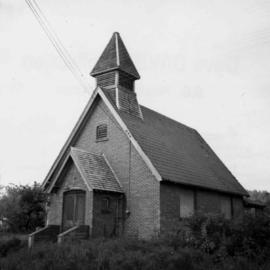
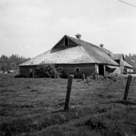
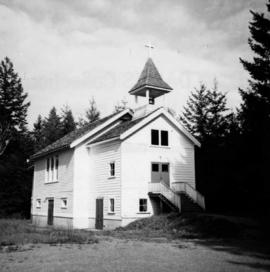
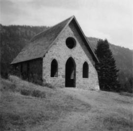
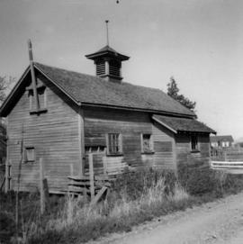
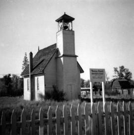
Photograph depicts a church built in 1876 in Nicola, 7 miles northeast of Merritt. It was originally a Presbyterian church and is one of the oldest in the interior, though it is now infrequently used.
Photograph depicts an unused church at Clayburn, near Abbotsford, B.C. The church and about half the buildings in the village are made of brick.
Photograph depicts a Chinese farmer's buildings on the Port Guichon Rd. on the outskirts of Ladner, B.C.
Photograph depicts Chinatown in Duncan, B.C. on Vancouver Island.
Photograph depicts the Chinatown in Duncan on Vancouver Island.
Photograph depicts a cattle shelter/ barn at the head of Nicola Lake, 20 miles east of Merritt, near the Douglas Lake road turnoff.
Photograph depicts a cattle shed located 3 miles east of Pavilion Lake, which is 15 miles northeast of Lillooet. It may have been a settler's cabin at one time.
Photograph depicts a cattle barn of the Douglas Lake Ranch.
Photograph depicts the catholic church at Cobble Hill on Shawnigan Lake.
Photograph depicts the Carmi Depot located at mile 46.6 on the CPR line in the Carmi Subdivision. This is the only surviving building at the depot. The layout here consisted of 4 passing/storage tracks and 1 short siding. The view is looking north and upgrade.
Photograph depicts a Canadian Customs House. The border crossing was only open between 8:00 a.m. and 5:00 p.m. daily.
Photograph depicts the Cameron Lake station on the Alberni branch of the Esquimalt and Nanaimo Railway on Vancouver Island. It is no longer used but has been converted to a lodge. The view is looking west.
Photograph depicts Cadero St. in the west end of Vancouver, looking north from Barclay St. intersection in the 800 block.
Photograph depicts a cabin near Williams Lake. Its interior contained two old treadle sewing machines and a chesterfield. Davies had the impression it had not been inhabited for at least a decade.
Photograph depicts "Butterchurch" that was built in 1870 under the direction of Father Rondeault of the Oblate Order for missionary work among the Comiakan Natives, a tribe of about 100. It was abandoned by about 1880 because of its location. It was recently restored as a historical shrine.
Photograph depicts buildings of the former Vancouver-Lansdale ferry. They appeared to now be used by Kingcome Navigation Co. as well as other businesses.
Photograph depicts small buildings sited on the north side of the tracks and just west of the Mission City CPR depot. They are all in use and well cared for.
File consists of documentary photographs taken by David Davies of stores and service buildings in British Columbia.
File consists of documentary photographs taken by David Davies of public buildings in British Columbia.
File consists of documentary photographs taken by David Davies of log dwellings in British Columbia.
File consists of documentary photographs taken by David Davies of various houses in British Columbia.
File consists of documentary photographs taken by David Davies of hotels in British Columbia.
File consists of documentary photographs taken by David Davies of commercial and industrial buildings in British Columbia.
File consists of documentary photographs taken by David Davies of churches in British Columbia.
File consists of documentary photographs taken by David Davies of agricultural buildings in British Columbia.
File consists of documentary photographs taken by David Davies of buildings in British Columbia.
Photograph depicts the Buckingham Apartments at 925 Cardero St.and Barclay St. in Vancouver, B.C.
Photograph depicts the Buckingham Apartments at 925 Cardero St. in Vancouver, B.C. after a snowfall. The view is looking south and depicts Barclay St. crossing in the foreground.
Photograph depicts British Navy cottages (styled after cottages in the U.K.) in Esquimalt. Built when Dockyard was operated by the Imperial Navy.
Photograph depicts the Britannia Copper Mine in Howe Sound. The view is looking southeast.
Photograph depicts the brick works at Haney, B.C., within 100 yards of the Fraser River. Current production appeared to be bricks, tiles, and flowerpots. There is a disused railway spur in the works
Photograph depicts about the only brick house in North Wellington, Nanaimo. It was possibly built about 1860-1870 when coal working first commenced.
Photograph depicts one of the earlier brick buildings beside the river, sited opposite the sternwheeler landing pier. It is called Commercial Block and was built in 1897.
Photograph depicts a former fire hall now used as a boy's club on 12th Ave and St. Catherine's St., in Vancouver, B.C. It is one and a quarter miles southeast of C.N.R. station.
Photograph depicts the Bowser water tower on the Esquimalt and Nanaimo Railway, 25 miles south of Courtenay. The view is looking north.
Photograph depicts a booster telegraph relay station at Carmi. Carmi is located at mile 46.6 on the CPR line on the Carmi Subdivision. This is the only surviving telegraph pole between Penticton and Beaverdell. The view is looking east.
Photograph depicts a boathouse at an unknown location.
Photograph depicts the B.C. Forest Service Ranger's administration and equipment building at Pender Harbour in Sechelt, B.C.
Photograph depicts the B.C. Electric Railway workshops at the south end of the Burrard bridge in Vancouver. The view is looking west and depicts caboose A10 in the background.
Photograph depicts the B.C. Electric Railway depot at Huntingdon and Sumas, about 20 ft from the U.S.-Canadian border. The view is looking southeast.
Photograph depicts a barn located on the south side of Kokamee Creek, part of Kootenay Lake.
Photograph depicts a barn in the Upper Fraser Valley, west of the Vedder crossing and southwest of Atchelitz.
Photograph depicts a barn advertised for rent on Liverpool Rd. in South Westminster. Barn later half demolished on April 17, 1966.
Photograph depicts a barn located in Aspen Grove.
Photograph depicts a barn attached to Watch Lake Lodge, a dude ranch.
Photograph depicts a barn at Port Guichon, 1 mile west of Ladner, Delta.
Photograph depicts a barn at Lund, a village 12 miles north of Powell River. This building overlooks the harbour.
Photograph depicts a barn of the Glenwalker Ranch. Built in 1890-1910.
Photograph depicts a barn at Darfield, near Barriere, about 35 miles north of Kamloops. The English timbered cottage developed from this architectural form.
Photograph depicts a bandstand at English Bay in Vancouver, B.C.