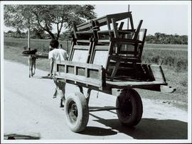
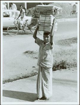
Item is a photograph of a man pulling a furniture laden cart along a road.
Item is a photograph of a man on the side of a river fishing with a net.
Item is a photograph of lumber piled along a commercial street.
Item is a photograph of two men swede sawing a log.
Item is a photograph of a house under construction. Unknown individual sits on ground in foreground.
Item is a photograph of rows of plants in a garden.
Item is a photograph of a forested area.
Item is a photograph of a street food vendor.
Item is a photograph of a fishing boat with the net deployed with other boats and people on shore.
Item is a photograph of building construction with bamboo scaffolding.
Item is a photograph of men doing wood construction.
Item is a photograph of the Chittagong Research Institute buildings.
Item is a photograph of a boy carrying a bundle of books on his head.
Item is a photograph of boats docked on the shore behind piles of grain or straw.
Item is a photograph of a boat under construction.
Item is a photograph of a bicycle repair shop.
Item is a photograph of a pile of bamboo in a field.
Item is a photograph of a river bend and the surrounding country taken from the air.
Photograph depicts a view from the shore of Babine Lake looking across the water to forest and snowy mountain peaks in the distance. [55th parallel]
Photograph depicts a group of men and dogs standing outdoors in the sunshine.
Photograph depicts rolling hills with dry vegetation and river in the background.
File consists of the following articles and speeches written by Knox McCusker:
- "Reminiscences of Knox McCusker" (63 typewritten pages)
- "Back and Beyond the Peace" by K.McCusker (taken from the Toronto Star Weekly Saturday May 5, 1928) – retyped
- "The Alaska Highway" by Knox F. McCusker, D.L.S. (The Canadian Surveyor, July 1943)-photocopy
- Mr. McCusker's speech (5 pages)
- “Tropical Valleys of B.C.” (4 pages)
- "The president has called me an old old surveyor…" speech written by K. McCusker
- "In the early days of my career in the Surveying profession…" written by K. McCusker
File consists of the following items:
- "Mac" by D.L. Surveyor
- "Knox (Mac) McCusker: Dominion Land Surveyor" by E.L. Rutherford, V.C. Brink, R.S. Silver and M.Z. (Smokey) Neighbour
- Excerpts from Men and Meridians by Don W. Thomson
- Article re: Knox McCusker written on the occasion of his death (April 14, 1955)
- "McKusker (sic) to open up Blueberry Mountain Area" (Alaska Highway News, June 8, 1950)
- "McCusker was surveyor, big game guide….also rancher and trail blazer"
- "Knox Freeman McCusker" written on the occasion of his death (The Canadian Surveyor, July 1955)
- "Veteran Surveyor - Alaska Highway Stories"
- Memories of Knox McCusker by his oldest niece Betty (McCusker) Rutherford
- "Veteran Surveyor prefers horses for long bush treks" by Eric Young (Edmonton Journal)
- Eulogy for Knox McCusker read by Stanley D. Seif at Burch Presbyterian Church in Fort St. John, B.C.
- Eulogy for Gwendolyn Dorothy McCusker (July 1997)
- "Tropical Valley No Myth: amazing story of woman who lived there" by Thomas A. Wayling (Vancouver Sun)
- Photocopy of section of map: "Topographical sketch map showing route traversed by the Bedaux Sub-Arctic Expedition 1934 through the Rocky Mountains" (by Frank Swannell, March 27, 1935)
- Memories of Knox McCusker by Bill McCusker, his oldest nephew
- "There is always a reason; destiny made it a date. The corridor of the Alcan didn’t just happen" (Fort St. John publication)
- Article on Knox McCusker (ALS News, Winter 1983)
Collection consists of a photograph album from A. H. Holland, a British Columbia Land Surveyor, that was created while working in the Central Interior, the Cariboo, the Chilcotin and southeast British Columbia. This album visually documents steamboat, stagecoach and horse travel in British Columbia and also captures the prepatory work and dawn of the age of rail travel.
Holland, Arthur H.Series consists of a photograph album from A. H. Holland, a British Columbia Land Surveyor, that was created while working in the Central Interior, the Cariboo, the Chilcotin and southeast British Columbia. This album visually documents steamboat, stagecoach and horse travel in British Columbia and some First Nation village sites. It also captures preparatory survey work and dawn of the age of rail travel.
Photograph depicts A. H. Holland viewing North Fork valley from a high mountain ridge.
File consists of notes, letters, and reproductions relating to the "Arrival of Steel" CN Railway plaque in Prince George. Includes: "Invitation" from the City of Prince George for the unveiling of the CN plaque (27 Jan. 1989) and correspondence letters between CN and the City of Prince George (1987-1989). Also includes photographs depicting the CN plaque and the unveiling ceremony (Jan. 1989).
Photograph depicts twenty-eight or more people standing on the river's edge, a stack of wood is ready for loading on the steamer that is anchored near the shore.
Photograph depicts a view of the river shore, a few scattered buildings and tents are near the shore. A footpath leads from the water's edge between the dwellings and through the newly cleared land.
Photograph depicts view from the steamboat deck approaching Cottonwood Canyon.
Photograph depicts a view from the steamboat deck approaching Cottonwood Canyon.
Photograph depicts snow covered trees and forest.
Photograph depicts an open field with a fence, house and shed in the midground, low treed hills in the background.
File consists of reproduced copy of "To the Memory of Alexander Mackenzie's Granddaughter and last Descendant Mrs. Heald (Alexandra Isabel Mackenzie)" originally published in 1933.
File consists of notes, clippings, and reproductions relating to the new Alexander Mackenzie monument in Fort George Park (renamed Lheidli T'enneh Memorial Park). Includes: "British Columbia Heritage Brigade Journey" pamphlet from Parks Canada and Canoe Sport B.C. (1985); "Alexander Mackenzie Trail Association" newsletter No. 9 (1987); "Alexander Mackenzie Voyageur Association" newsletter No. 36 (1994); and correspondence letters between John D. Adams, Supervisor of Interpretation and Heritage Site operations for the Province of British Columbia and Kent Sedgwick (Apr.- May 1986). Also includes photographs depicting the new Alexander Mackenzie monument and people at the unveiling (1985).
File consists of notes, clippings, and reproductions relating to the Alexander Mackenzie monument in Prince George. Includes a photograph depicting Judge Howay at the unveiling of the original National Historic Monument to Alexander Mackenzie in Prince George on 13 June 1925 (reproduced 2009).
File consists of bound documents, plans, and reproductions. Includes: "Public input summary" spiral bound book from Parks Canada (Dec. 1985) and "Alexander Mackenzie Heritage Trail" bound book published by Parks Canada (17 July 1985).
Subseries consists of material created and collected by Kent Sedgwick during his involvement with the Alexander Mackenzie Heritage Trail Association. Sedgwick was the treasurer and later the president of the Alexander Mackenzie Voyageur Route Association. The association was formed to create the first official heritage trail in British Columbia. The trail is now called the Nuxalk-Carrier Grease Trail and is part of the route across Canada followed by Alexander Mackenzie in 1789 to 1793. The association aided in having the route recognized by each provincial government and the federal government. The files primarily consist of management plans, summary documents, booklets, and pamphlets created by the association, the provincial government, and Parks Canada.
Consists of a photograph album that contains photographs that depict Parker Bonney's early years as a Forest Engineer. Includes photographs of the expedition to the Nass Valley undertaken by Parker Bonney, Sam Brown, and others. May also include photographs of later surveying expeditions.
Consists of a photograph album that contains 224 photographs that depict Parker Bonney's early years as a Forest Engineer. Includes photographs of the expedition to the Nass Valley undertaken by Parker Bonney, Sam Brown, and others. May also include photographs of later surveying expeditions. Also includes three photographs of the University of Washington rowing team, of which Parker Bonney was a member between 1909 and 1913.
This travel scrapbook was created by Jill Singleton to document a trip to Alaska, Yukon, Haida Gwaii, and northern BC. Jill Singleton and Eric Stathers embarked on a 1985 car camping trip using the BC Ferries and Alaska Ferry systems. Includes postcards, ephemera, handwritten notes, pamphlets, issues of local newspapers, and maps. Also includes 37 photographs.
Includes the following:
- "Queen Charlotte Islands Observer" newspaper issue for August 8, 1985
- "A Walking Tour and Business Directory for Queen Charlotte City", June 1985
- "A Walking Tour and Business Directory for Tlell + Port Clements", June 1985
- "A Walking Tour and Business Directory for Skidegate Landing, Skidegate and Sandspit", June 1985
- "A Walking Tour and Business Directory for Masset", June 1985
- "Explorations Q.C.I." pamphlet advertising guiding, outfitting, and touring
- "Sandspit Inn, Queen Charlotte Islands" pamphlet
- "Visit the Queen Charlottes" pamphlet
- Queen Charlotte Islands map, circa 1985
- BC Ferries pamphlet "New in 1985... Inside Passage Day Cruise"
- BC Ferries pamphlet "Tickets and Boarding Information, Inside Passage"
- "Alaska Marine Highway" pamphlet
- "Discover Southeast Alaska, Ketchikan" pamphlet
- "Alaska State Parks" pamphlet/map
- "Tongass National Forest, Alaska" pamphlet/map
- "Alaska Marine Highway Summer Schedule - May 1, 1985 through September 30, 1985" pamphlet
- History leaflet for St. Michael's Cathedral, Sitka, AK
- Alaska Seafood Marketing Institute leaflets, 1984
- Anchorage 1984 Visitors Guide, Anchorage Convention & Visitors Bureau
- "Skagway... some Steps on the Gold Rush Trail... walking Tour of the Historic District - Klondike Gold Rush National Historical Park"
- "Skaguay Alaskan" newspaper issue, Vol. VIII, No. 1880 (1985)
- "Klondike Gold Rush" pamphlet for tourists
- "Broadway, Skagway, Alaska" pamphlet
- "S.S. Tutshi, Carcross" pamphlet
- "Moon Watching" pamphlet by BC Ministry of Lands, Parks and Housing (1980)
- "Some Insects of Provincial Parks" pamphlet by BC Ministry of Lands, Parks and Housing (1980)
- "Stewart, British Columbia - Hyder, Alaska... Your Gateway to Alaska and the Yukon!" pamphlet
- "Stewart-Cassiar Highway 37" map
- "Prince Rupert City Map & Guide" pamphlet
- "Explore Canada's Yellowhead, Western Canada's New Interprovincial Highway" pamphlet (1983)
- "101 Things To Do in Yukon" booklet published by Tourism Yukon (1985)
- "Your Guide to B.C. Ferries' Inside Passage" booklet by British Columbia Ferry Corporation (1985)
- "Port Alberni, British Columbia, Canada" booklet (1981)
Trip itinerary:
- Vancouver, BC
- Nanaimo, BC
- Port Hardy, BC
- Prince Rupert, BC
- Yakoun River, BC
- Haida Gwaii, BC (formerly Queen Charlotte Islands)
- Rennell Sound, BC
- Graham Island, BC
- Queen Charlotte City, BC
- Sandspit, BC
- Prince Rupert, BC
- Ketchikan, AK
- Sitka, AK
- Tenakee Springs, AK
- Juneau, AK
- Skagway, BC
- Carcross, YK
- Atlin, BC
- Telegraph Creek, BC
- Kitwanga, BC
- Prince Rupert, BC
- Prince George, BC
- Lillooet, BC
- Vancouver, BC
Fonds consists of original, silent 16mm reels that portray the natural, social and land use history of the Bella Coola and Chilcotin regions named the "Natural and Guiding History of the Bella Coola and Chilcotin Regions".
Possible locations that Al Elsey filmed include: Bella Coola, Bella Bella, Anahim Lake, Alert Bay, Nimpo Lake, Bulkey Valley, the Rainbow Mountains, Tweedsmuir Provincial Park, Dean River, Bella Coola River, Tchaha Lake, the Chilcotin region, the Ulkatcho Mountains, Lassard Lake, Fenton Lake, Atnarko River, Wells Gray Park, and Holt Homestead.
Image depicts a marker for aerial photography at an uncertain location. The slide labels it as "Elizabeth Station."
Photograph depicts a southeast aerial view from Sustut Pass of a snow-covered mountain range toward Thutade Lake.
Photograph depicts an aerial view of the north half of Thutade Lake located between a snow-capped mountain range.
Photograph depicts an aerial view of Finlay Falls from below Thutade Lake set in a forested landscape.
Photograph is one of seven images believed to have been taken on a Canadian University Service Overseas (CUSO) mission in Mozambique; see also items 2009.6.1.483 - 2009.6.1.489.
Photograph depicts a northwest aerial view from Sustut River of a snow-covered mountain range toward Thutade Lake.
Photograph depicts a northwest aerial view from Sustut Pass of a snow-covered mountain range toward Thutade Lake.