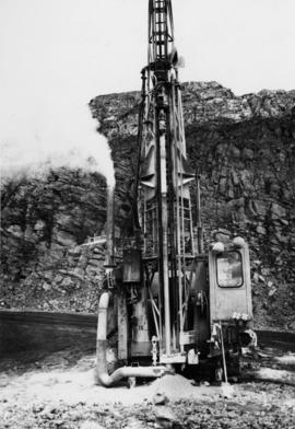
Photograph depicts an Atlas Copco Drillmaster (blasthole drill) near the mine road, mountainside in background. This is a precision hammer drill which had its own power source. It is believed that this photo was taken on the North ridge, near the cirque dump. Handwritten annotation on verso of photograph: "1961".
Photograph depicts mine area at Cassiar, crushing plant visible on left. Various mine buildings visible midground. Blasthole drills, shovels, dozers, and dump trucks can be seen on bench in foreground at 6430 elevation. Handwritten annotations on recto of photograph: "6"; "View looking NW from top of S. peak 6790 elev. on 6430 stripping bench on it and 6050 ore bench further down on left."; "July 1961".
Photograph depicts bench at 6430 elevation. Blasthole drills, shovels, dozers, and dump trucks can be seen on bench in midground. Mine valley in background. Handwritten annotation on verso of photograph: "1961".
Image depicts an old log cabin at an uncertain location.
Image depicts a view of the property at 153 Mile House, near Quesnel, B.C.
Image depicts the Crosina Store at 153 Mile House.
Image depicts 153 Mile House.
Image depicts the Watson Mansion in 108 Mile Ranch, B.C. It burned down in 1983 as the result of a chimney fire.
Image depicts a field and pond somewhere in 108 Mile Ranch, B.C.
Image depicts 108 Mile Ranch, B.C.
Image depicts what appears to be a sawmill at 100 Mile House, B.C.
Image depicts 100 Mile House, B.C.