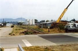
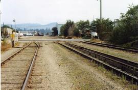
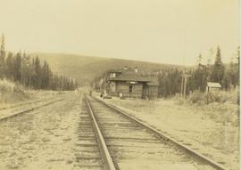
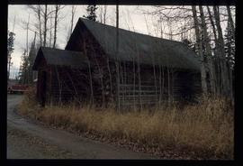
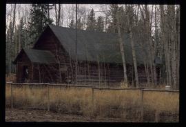
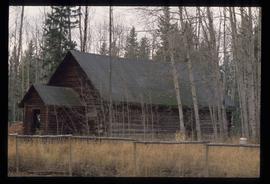
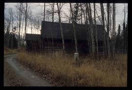
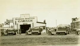
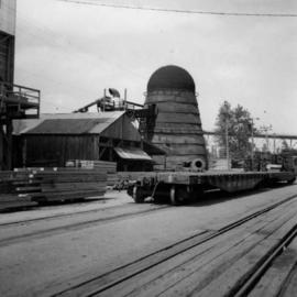
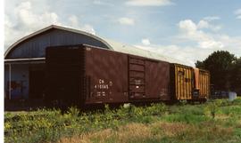
Photograph depicts Beaver Trucking located on Kamloops Indian Reserve No. 1 on Tk'emlups te Secwepemc territory, Kamloops, BC. It had been a company since 1990 and received 2 or 3 boxcars weekly loaded with items from Toronto that were then delivered around town. Davies later noted that the business was destroyed by arson in 1997.
Image depicts a field of hay somewhere in Beaver Valley.
Photograph depicts the Beaverdell Bridge, located between Rock Creek and Kelowna, BC
Photograph depicts the CPR Beaverdell depot located at about 35 miles northeast of Osoyoos and at mile 91.4 east of Penticton on the Carmi Subdivision. The traffic here is ore from a local mine, some lumber, and freight for the village. The depot building is in use and has a telegraph. There is also siding capacity for 31 cars. This section was built between 1914 and 1915. The view is looking north.
Photograph depicts the CPR depot at Beaverdell, located at about mile 42.3 on the Carmi Subdivision. To the right is an ore loader for concentrate from mines. There is no rail traffic at this date. The view is looking north.
Image depicts a log cabin in Beaverly.
Image depicts what appears to be a small ranch. The slide is labelled "Becher's Prairie," possibly meaning Becher's Prairie Provincial Park in B.C.
Photograph depicts wood building and signage, with traffic regulating beams raised on either side.
Handwritten annotation on verso reads: “Dawson Creek B.C. Bechtel Price Callahan Dispatch Office [1943]”
Annotation on recto: "C-08431" which denotes the same photograph in the collection of the BC Archives.
Annotation on recto: "Bedeaux in camp at Gundy, B.C." Photograph depicts a man (Charles Bedaux?) standing amongst tents and a car.
Annotation on recto: "Bedeaux party saying au revoir outside Hart home at Pouce Coup" Photograph of seven men and women standing beside a loaded vehicle parked in front of a house. Charles Bedeaux if third from the right.
Annotation on recto: "Bedeaux's Party camped at Gundy, B.C." Photograph depicts tents men standing amongst tents and supplies.
Annotation on verso: "Bedeaux's Party leaving Hart Hotel and Pouce Coupe, B.C. for North"
Annotation on verso: "Pouce Coupe, B.C."
Image depicts an esker at Bednesti Lake, B.C.
Image depicts a man in a yellow cap who appears to be blowing smoke into a bee colony at a bee farm. It appears to be an educational demonstration.
Image depicts a bee-hive burner beside a rail-road track at an unidentified mill somewhere in Prince George, B.C.
Image depicts a beehive burner, as well as rail road tracks, at an unknown location.
Image depicts a Beehive Burner along the Nechako on River Road. Map coordinates 53°55'34.1"N 122°44'58.0"W
Image depicts a Beehive Burner along the Nechako on River Road. Map coordinates 53°55'34.1"N 122°44'58.0"W.
Photograph depicts a beehive burner at Brownsville Sawmills Ltd. On Olson St. in south Westminster, Surrey. It is on the banks of the Fraser River just below the Patullo Bridge.
Image depicts a Beehive Burner along the Nechako on River Road. Map coordinates 53°55'34.1"N 122°44'58.0"W
Photograph depicts large group of men gathered outside large building with the sign "WHITEHORSE GRILL".
Handwritten photo album caption below this photo reads: "Dawson Creek BC / 1943 Beer Ration Day".
Foreground shows two rocky shores covered in dirt and wood debris, connected by a barely visible bridge. Annotation on recto reads: "Before the Blast Apr. 24th 13"
Photograph depicts the downtown area in which prior to 1998, the CNR had a loop. It ran west beside Clement and after crossing over Ellis, turned north for a couple of blocks, then turned east, back over Ellis, and along Recreation Street and Weddell.
Photograph depicts a shallow ditch cut into rocky terrain that leads through a forested landscape.
Photograph depicts a church and unidentified building with a large fenced yard in the foreground. Annotation on verso of photograph states: "Bella Bella Church"
Photograph depicts the interior of a church decorated with white streamers. Annotation on verso states: "Canada, B.C., Indian(?) Bella Bella Church decorated for Christmas by Indian "decoration""
Photograph depicts a First Nations cemetery built on a rocky shoreline.
Image depicts Bellos Road, most likely in Red Rock, B.C.
Photograph depicts Belmont Park Fort on the west side of Esquimalt Harbour. It was built by the British Royal Engineers in 1895 to protect the naval base. Photo shows the lower fort with 2 gun emplacements.
Photograph depicts the entrance to the magazine feeding gun emplacement in the lower fort of Belmont Park Fort in Esquimalt Harbour.
Photograph depicts one of the 2 gun emplacements in the lower fort of Belmont Park Fort protecting Esquimalt Harbour.
Photograph depicts the one and only gun emplacement in the upper fort of Belmont Park Fort protecting Esquimalt Harbour.
Item is a photograph of the beltway used to carry aggregate to the Dam site.