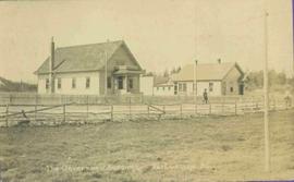
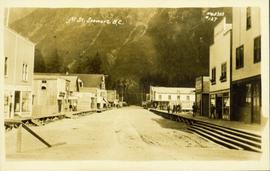
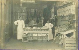
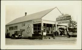
Photograph depicts the interior of a grocery shop displaying eggs, scale, sides of meat, bananas, other produce and 2 shop attendants. Sign above table reads: Morrow & Frizzell. Handwritten annotation in pencil on recto reads: “Port Essington B. C. 1907”.
Item consists of transcript of documentary consisting of forum with prominent members of the forest industry discussing the history of forestry in North Central British Columbia c.1960s-c.1980s. Participants include Bill Young, Keith Yorston, Ken Bernsohn, Hector Richmond, Russ Cousins, Harry Gairns, Don Gould, Orville Gorley, Frank Oberle, Includes 'logger's commandments' song.
Harkins, BobPhoto of buildings behind street, fenced on either side. Man and horse can be seen on street. Printed annotation on verso reads: “The Government buildings Fort George B. C.” Handwritten annotation on recto reads: “This is the place I receive my patent from next June.”
Photograph depicts Mr. Tom Herne seated in chair to right of cluttered office desk at Hudson Bay Company Post. Framed wall hangings, calendar, file cabinet, and telephone in background.
Image depicts the Germansen Landing Trading Post.
Handwritten annotation on verso of photograph reads: "George St. Prince George BC Photo. S Wrathall". Prince George Hotel and Cafe stand on left side of street in foreground, and many other buildings and businesses can be seen. Vehicles line the street, cut banks visible in background. Photograph believed to have been taken while George Street was being prepared for a new lawyer of asphalt.
Street level photo of George Street in Prince George. Visible businesses include "B-A" and "Astoria Hotel." Printed annotation on recto reads: "George St. Prince George."
Street level photo of George Street in Prince George, Visible businesses include the "Prince George Hotel" and "Ford" dealership. Printed annotation on recto reads: "George St. Looking North Prince George, B.C. N&D."
Image depicts a view of George Street with the Prince George Hotel.
Slightly elevated view of an intersection surrounded by residential and business buildings in Prince Rupert BC. Printed annotation on recto reads: "General View Prince Rupert. B.C. W.W.W."
Photograph depicts young girl standing on front deck of "WANAMAKER'S GENERAL MERCHANDISE." Car visible on left, gas pump in front. Trees and neighbouring house visible in background. Handwritten annotation on recto of photograph: "ATLIN."
Elevated street view of Fulton Street in Prince Rupert, BC. City Hall is in the left foreground. Hills and water are visible in the background. Printed annotation on recto reads: "Fulton St. Prince Rupert. B.C. W.W.W."
Street view photograph taken at the intersection of Front Street and Carson Avenue. Several men are gathered at Cowan's Hardware store on the corner. Also visible in this photograph is the Cariboo Hotel (visible furthest to the left), and the British American Hotel which is partially visible behind the J.A. Fraser store. Printed annotation on recto reads: "On Front Street, Quesnel, B.C."
Photograph is part of a series of photographs depicting Olin Corporation's Fria location.
Photograph depicts opposite shore in background behind river, bushes and trees in foreground. Handwritten photo caption on verso and recto of this photograph reads: "Fraser River at the mouth of the Clearwater".
Men stand wearing vests and ties in doorway framed in corner of building with the sign: "R. CUNNINGHAM LTD. GENERAL MERCHANDISE." Various other advertisements hang from doorway. Man on left believed to be transport driver also featured in items 2009.5.1.80 & 2009.5.1.81. Handwritten annotation on recto of photograph: "Hazelton, B.C. 1910".
Image depicts the interior of a store, possibly in Fort St. John, B.C.
Image depicts the old Trading Outpost in Fort St. James, B.C.
Image depicts the interior of the historic Hudson's Bay Company Trading Post, with several unknown individuals present, in Fort St. James, B.C.
Image depicts the interior of the historic Hudson's Bay Company Trading Post in Fort St. James, B.C.
Image depicts the interior of the historic Hudson's Bay Company Trading Post, with several unknown individuals present, in Fort St. James, B.C.
Photograph depicts the early settlement of Fort George. The buildings to the left of the fence are believed to be owned by the Hudson's Bay Company. The land to the right of the fence belonged to the Fort George Reserve, the home of today's Lheidli T'enneh Band who relocated to a reserve at Shelley when this reserve was sold in 1912. Handwritten annotation on verso and recto of this photograph reads: "Fort George from opposite side of Fraser River".
Image depicts the abandoned and crumbling Forman's General Store somewhere in or near either Barkerville or Wells, B.C.
Photograph depicts one woman with her back turned, and four men standing on scow next to chairs and table adorned with food. Trees on shore in background. Handwritten annotation on recto of photograph reads: "Bourchier Scow".
Street view photograph of 5th Street. Printed annotation on recto reads: "5th St. Stewart, B.C. Hughes #127."
Photograph is part of a series of photographs depicting Olin Corporation's Fria location.
Item is a photograph of Ben Ginter signing the agreement for Eurocan’s pulp mill license while Mr. Williston looks on.
Photograph depicts two men standing and paddling in canoe on river, trees stand above rock face on opposite shore in background. Handwritten photo caption on verso and recto of this photograph reads: "Entering the Grand Canyon."
Item is a photograph of Dennis Kennedy of BC Hydro, Gordon McNabb head of the federal engineering advisory team, and Gordon Kidd of the BC Water Resources Branch.
Image depicts the Endako General Store in Endako, B.C.
Photograph is part of a series of photographs depicting Olin Corporation's Fria location.
Elevated view of Third Avenue in Prince Rupert. Signs for "Chris Mill Bakery" and "Overwaitea" are visible on the left side of photograph. Printed annotation on recto reads: "3rd Ave Prince Rupert BC."
Elevated photograph of Prince Rupert taken from a hill. Residential and business buildings are visible. Background shows water and wooded hills. Printed annotation on recto reads: "Prince Rupert BC 22."
Photograph of several commercial and residential buildings, including the church and "The Big Furniture Store." Annotation on recto reads: "Prince Rupert. BC Allen Photo July '11." Handwritten annotation on verso reads: "Early day- Prince Rupert."
Photograph is part of a series of photographs depicting Olin Corporation's Fria location.
Photograph depicts three men standing in front of drugstore, and a woman in doorway of attached post office. Cleared area in foreground, bushes and trees in background. Handwritten annotation on verso of photograph: "Drug Store & Post Office South Fort George."
Street view of various buildings in Stewart, BC, covered with a heavy layer of snow. Visible businesses include "The R. Boyd Young Co." and "Stewart Land Co." Printed annotation on recto reads: "Stewart B.C. Hughes 78."
Image depicts George St in downtown Prince George with City Hall in the background. Also visible are the Prince George Hotel and a movie theatre. Map coordinates 53°54'55.0"N 122°44'36.1"W
Image depicts George St in downtown Prince George with City Hall in the background. Also visible are the Prince George Hotel, Ming's Inn Chinese Restaurant, Fraser Stationers Ltd., Weiner King food cart, and a movie theatre. Map coordinates 53°54'55.0"N 122°44'36.1"W
Image depicts 4th Ave at Brunswick St. and the following businesses: Hart Drugs, The Yarn Barn, and Saveco. Map coordinates 53°54'59.9"N 122°44'52.9"W
Image depicts 4th Ave at Quebec St, showing the following businesses: The Yarn Barn, Golden Chalice Jewellers, Dandy Lines, Ultrasport, and Saveco. Map coordinates 53°54'58.6"N 122°44'47.5"W
Image depicts downtown Prince George, B.C.
Image depicts an aerial view of downtown Prince George, B.C.
Photograph depicts group of eight men standing in line in the Cassiar valley. Left to right: Charles Rainforth Elliot, John Drybrough, John E. Kennedy, Fred Martin Connell, W. Harold Connell, Ken A. Creery, George Washington Smith, Tam Zimmermann. Power lines and mountains in background.
Photograph depicts group of eleven men standing in line in the Cassiar valley. Left to right: Jack Christian, Charles Rainforth Elliot, John Drybrough, John E. Kennedy, Fred Martin Connell, W. Harold Connell, Ken A. Creery, George Washington Smith, Tam Zimmermann, [Fred Murray]?, Nick Gritzuk. Power lines and mountains in background. Most men featured in photo are believed to be members of Cassiar's Board of Directors. Photograph was originally framed with note "Summer 1961" written on cardboard backing.
Photograph depicts group of eleven men standing in line in the Cassiar valley. Left to right: Jack Christian, Charles Rainforth Elliot, John Drybrough, John E. Kennedy, Fred Martin Connell, W. Harold Connell, Ken A. Creery, George Washington Smith, Tam Zimmermann, [Fred Murray]?, Nick Gritzuk. Creery looks through his own camera, appearing to photograph the photographer. Power lines and mountains in background. Most men featured in photo are believed to be members of Cassiar's Board of Directors.
Photograph depicts group of eight men standing on front steps of Cassiar's Main Office building. Top, left to right: Ken A. Creery, John Drybrough. Middle, left to right: John E. Kennedy, Tam Zimmermann. Bottom, left to right: Fred Martin Connell, George Washington Smith, W. Harold Connell, Charles Rainforth Elliot. Windows and doors to office in background, flowers in bottom right foreground. Photo believed to have been taken on the same day as items 2000.1.1.4.3.4 - 2000.1.1.4.3.6.