Title and statement of responsibility area
Titel
Algemene aanduiding van het materiaal
- Graphic material
Parallelle titel
Overige titelinformatie
Title statements of responsibility
Titel aantekeningen
Beschrijvingsniveau
archiefbewaarplaats
referentie code
Editie
Editie
Edition statement of responsibility
Class of material specific details area
Statement of scale (cartographic)
Statement of projection (cartographic)
Statement of coordinates (cartographic)
Statement of scale (architectural)
Issuing jurisdiction and denomination (philatelic)
Datering archiefvorming
Datum(s)
-
1966 - 1991 (Vervaardig)
Fysieke beschrijving
Fysieke beschrijving
12 photographs : col. ; 11.5 x 17.5 cm and smaller
Publisher's series area
Title proper of publisher's series
Parallel titles of publisher's series
Other title information of publisher's series
Statement of responsibility relating to publisher's series
Numbering within publisher's series
Note on publisher's series
Archivistische beschrijving
Naam van de archiefvormer
Bereik en inhoud
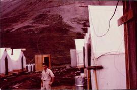
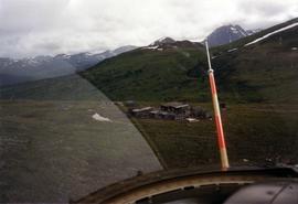
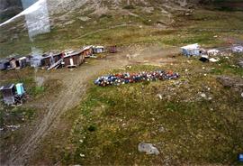
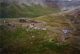
This collection is of Kutcho Creek Camp that was set up by a crew led by Cassiar's Chief Geologist Bill Plumb in 1966.
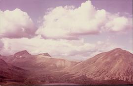
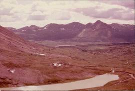
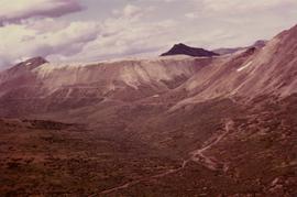
There are six photographs showing the temporary buildings, paths and barrels. These photos were taken from a high hill looking down at the camp. Two photographs depicts the valley of Kutcho Creek area, and the exploration camp is in the distance at foot of hill. One photograph depicts valley of Kutcho Creek area with a body of water in foreground, and mountains in background.
Another photograph depicts man believed to be Matt Bell standing in Kutcho Creek exploration camp. There are tents on either side, a wood structure in background and a sign on wood post: "PLUMB BLVD."
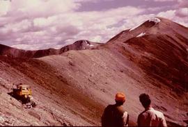
One photograph believed to have been taken near Kutcho Creek, during the initial exploration trip led by Cassiar's Chief Geologist Bill Plumb. Bill stands to left of man believed to be Matt Bell in right foreground. Bulldozer works along talus slope in left foreground.
Another photograph of this initial trip shows a bulldozer working along talus slope in centre of image.
Aantekeningen
Ordening
Arrangement determined by archivist.
Taal van het materiaal
- Engels
Schrift van het materiaal
Plaats van originelen
Beschikbaarheid in andere opslagformaten
Restrictions on access
Termen voor gebruik, reproductie en publicatie.
Personal or academic use of photographic materials is welcomed under the standard fair use and educational use clauses of Canadian Copyright Law. Commercial use is, however, forbidden without the express permission of the copyright holder. For information on obtaining written permission from the copyright holder, please contact the Northern B.C. Archives and Special Collections
Toegangen
Generated finding aid
Associated materials
These photographs are linked to exploration of Bill Plumb 2000.1.1.1.7