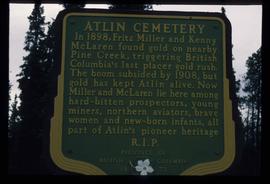
Print preview Close

Showing 5116 results

Archival description
3026 results with digital objects Show results with digital objects
Gravel
2012.13.1.124.19 · Stuk · Oct. 1975
Part of J. Kent Sedgwick fonds

Image depicts layers of gravel at the BCR site in Prince George, B.C.

Gravel
2012.13.1.124.18 · Stuk · Oct. 1975
Part of J. Kent Sedgwick fonds

Image depicts layers of gravel at the BCR site in Prince George, B.C.

Sand Beds
2012.13.1.124.17 · Stuk · Oct. 1975
Part of J. Kent Sedgwick fonds

Image depicts sand beds with a shovel present for size reference. The slide places it at the "BCR site," possibly in Prince George, B.C.

Varves
2012.13.1.124.16 · Stuk · Oct. 1975
Part of J. Kent Sedgwick fonds

Image depicts an example of varves, an annual layer of sediment or rock, with a pipe used for reference size. It is possibly located at the airport in Prince George, B.C.

Varves
2012.13.1.124.15 · Stuk · Oct. 1975
Part of J. Kent Sedgwick fonds

Image depicts an example of varves, an annual layer of sediment or rock, possibly located at the airport in Prince George, B.C.

Grooves
2012.13.1.124.14 · Stuk · June 1975
Part of J. Kent Sedgwick fonds

Image depicts an aerial view of a grooved region of land at an uncertain location.

Grooving
2012.13.1.124.13 · Stuk · June 1975
Part of J. Kent Sedgwick fonds

Image depicts an aerial view of a grooved region of land at an uncertain location.

Grooving
2012.13.1.124.12 · Stuk · June 1975
Part of J. Kent Sedgwick fonds

Image depicts an aerial view of a grooved region of land at an uncertain location.

Grooving
2012.13.1.124.11 · Stuk · June 1975
Part of J. Kent Sedgwick fonds

Image depicts an aerial view of a grooved region of land at an uncertain location.

2012.13.1.124.06 · Stuk · 1972
Part of J. Kent Sedgwick fonds

Image depicts a group of unidentified individuals walking along a crevasse filled ridge somewhere in the vicinity of Smithers, B.C. The slide also labels it as a "drift ridge."

Shore Line at Airport
2012.13.1.124.02 · Stuk · 1970
Part of J. Kent Sedgwick fonds

Image depicts the shore line and surrounding land of a lake or river at an airport, possibly in Prince George, B.C.

Intrusion
2012.13.1.124.01 · Stuk · 1970
Part of J. Kent Sedgwick fonds

Image depicts what is possibly an intrusive volcanic landform somewhere near Miworth, B.C.

A Bear
2012.13.1.98.71 · Stuk · 1999
Part of J. Kent Sedgwick fonds

Image depicts a bear, possibly a grizzly. The location is uncertain.

Highway and Mountains
2012.13.1.98.70 · Stuk · 1999
Part of J. Kent Sedgwick fonds

Image depicts a van on a highway with mountains in the distance; the location is uncertain, though it is possibly along the Alaska Highway.

Highway and Mountains
2012.13.1.98.68 · Stuk · 1999
Part of J. Kent Sedgwick fonds

Image depicts a van on a highway with mountains in the distance; the location is uncertain, though it is possibly along the Alaska Highway.

Miles Canyon - A River
2012.13.1.98.65 · Stuk · 1999
Part of J. Kent Sedgwick fonds

Image depicts a river in the Miles Canyon near Whitehorse Y.T. The Robert Lowe Bridge, built in 1922, can be seen over the canyon.

Miles Canyon - the Schwatka
2012.13.1.98.61 · Stuk · 1999
Part of J. Kent Sedgwick fonds

Image depicts numerous unidentified individuals getting off a boat which bears the name "Schwatka." It is located somewhere in Miles Canyon.

Eroding Rock Face?
2012.13.1.98.60 · Stuk · 1999
Part of J. Kent Sedgwick fonds

Image depicts what appears to be an eroding rock face. The slide itself is labelled "ash loger at top" for unknown reasons. Possibly located somewhere near Whitehorse, Y.T.

Alaska Highway
2012.13.1.98.59 · Stuk · 1999
Part of J. Kent Sedgwick fonds

Image depicts a small section of the Alaska Highway somewhere near Whitehorse, Y.T. The slide also appears to be labelled "army washing" for unknown reasons.

Miles Canyon? - Trees
2012.13.1.98.57 · Stuk · 1999
Part of J. Kent Sedgwick fonds

Image depicts numerous trees on the bank of a river, possibly in Miles Canyon near Whitehorse, Y.T. The slide is labelled "canyon city."

2012.13.1.98.55 · Stuk · 1999
Part of J. Kent Sedgwick fonds

Image depicts a memorial plaque which reads: "In memory of the Atlin men who gave their lives for their country in World War II," and then proceeds to list several individuals.

Atlin Cemetery Sign
2012.13.1.98.49 · Stuk · 1999
Part of J. Kent Sedgwick fonds

Image depicts a sign in the Atlin Cemetery, it reads: "In 1898, Fritz Miller and Kenny McLaren found gold on nearby Pine Creek, triggering British Columbia's last placer gold rush. The boom subsided by 1908, but gold has kept Atlin alive. Now Miller and McLaren lie here among hard-bitten prospectors, young miners, northern aviators, brave women and new-born infants, all part of Atlin's pioneer heritage R.I.P."

Atlin Lake?
2012.13.1.98.46 · Stuk · 1999
Part of J. Kent Sedgwick fonds

Image depicts what is possibly Atlin Lake, with numerous mountains in the distance and Atlin Mountain visible on the right of the image.

Atlin Road?
2012.13.1.98.43 · Stuk · 1999
Part of J. Kent Sedgwick fonds

Image depicts what is possibly Atlin Road. Numerous mountains are visible in the distance.