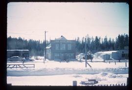
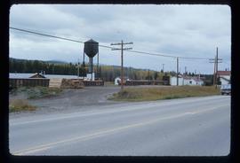
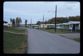
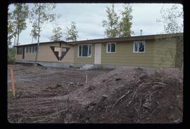
Image depicts what is likely the Dunkley Lumber Mill in Strathnaver, B.C.
Image depicts the Lone Butte Hotel in Lone Butte, B.C.
Image depicts a few buildings in Fraser Lake, B.C.
Image depicts several buildings in the community of Loos, B.C.
Image depicts several eighteen wheelers at the Pass Lake Road and Upper Fraser Road intersection with numerous houses and buildings in the background in McGregor, B.C. Map coordinates 54°04'38.1"N 121°50'00.1"W
Image depicts bunkhouse, restaurant and store in Sinclair Mills, B.C. Map coordinates 54°01'17.4"N 121°40'53.0"W
Image depicts two dilapidated houses in Sinclair Mills, B.C.
Image depicts several houses, and three goats standing on a narrow dirt road. The location is uncertain, likely Sinclair Mills, B.C.
Image depicts two old shacks and a mountain in the background. Possibly located in or near Longworth, B.C.
Image depicts several old shacks and some railway tracks running through Longworth, B.C.
Image depicts a group of people observing splintered wooden boards at an uncertain location.
Image depicts a cabin at an uncertain location.
Image depicts a row of houses in Upper Fraser, B.C. Map coordinates 54°06'51.6"N 121°56'26.3"W
Image depicts Upper Fraser residential area during demolition of town site. Map coordinates 54°06'51.6"N 121°56'26.3"W
Image depicts Upper Fraser Elementary School, after closure of town site. Map coordinates 54°06'54.4"N 121°56'16.6"W
Image depicts the entrance to the Upper Fraser mill yard in Upper Fraser, B.C. Map coordinates 54°07'10.8"N 121°56'51.7"W
Image depicts the Upper Fraser mill yard with a CN train in Upper Fraser, B.C. Map coordinates 54°07'10.8"N 121°56'51.7"W
Image depicts an open field and numerous buildings, including a church in Giscome, B.C. Map coordinates 54°04'03.2"N 122°22'04.6"W
Image depicts what is possibly the quarry located at Eaglet Lake in Giscome, B.C.
Image depicts debris left in residential area on Giscome, B.C. townsite. Map coordinates 54°04'16.7"N 122°21'55.1"W
Image depicts the Giscome railway station and buildings remaining in townsite in Giscome, B.C. Map coordinates 54°04'18.0"N 122°22'04.7"W
Image depicts several unidentified concrete structures that are badly damaged and cracking, located on old mill site in Giscome, B.C. Map coordinates 54°04'18.0"N 122°22'04.7"W
Image depicts the Giscome mill site in Giscome, B.C. The bunkhouse is no longer there and the school is in the foreground on the right. Map coordinates 54°04'04.8"N 122°22'04.7"W
Image depicts a muddy back road and an old shack at an uncertain location.
Image depicts the interior of a classroom at an uncertain location.
Image depicts the dairy farm in Giscome, B.C. Map coordinates 54°03'53.3"N 122°21'22.6"W
Image depicts a view of what appears to be a small town at an uncertain location.
Image depicts a house in Giscome, B.C. Map coordinates 54°04'17.6"N 122°22'06.1"W
Image depicts the old CN station in Giscome, B.C. Map coordinates 54°04'20.7"N 122°22'01.1"W
Image depicts an open field and Giscome, B.C. in the background. Map coordinates 54°03'52.9"N 122°22'10.0"W
Image depicts a row of houses at an uncertain location, possibly in Giscome, B.C.
Image depicts what is possibly the CN Railway Station and tracks located in Giscome, B.C.
Image depicts the Oblates of Mary Immaculate Catholic Church in Aleza Lake, B.C. Map coordinates 54°07'08.2"N 122°02'00.0"W
Image depicts Highway 97 at 15th Ave. looking north. Map coordinates 53°54'36.0"N 122°46'55.5"W
Image depicts the Canadian National Railway Yards in Prince George, B.C.
Image depicts a few houses, most likely near the airport in Prince George, B.C.
Image depicts a pipeline at Shelley, B.C.
Image depicts two mills; the Intercontinental Pulpmill is on the left side of the tracks in the image and the Prince George Pulp and Paper Mill is located on the right side in Prince George, B.C. The Northwood Pulp Mill can be seen in the distance.
Image depicts a train carrying logs somewhere in Prince George, B.c.
Image depicts an aerial view of Williams Lake, B.C.
Image depicts a train passing through Endako, B.C.
Image depicts a row of houses in Fraser Lake, B.C.
Image depicts a couple of houses in Fraser Lake, B.C.
Image depicts a row of houses in Mackenzie, B.C.
Image depicts the Esso gas station in Riske Creek, B.C.
Image depicts Highway 97 at 15th Ave. looking north. Map coordinates 53°54'42.1"N 122°46'53.1"W