Item
·
4/1/1980
Part of Mary Fallis fonds
21791 results with digital objects
Show results with digital objects
1996.2.5.4.4
·
File
·
2004
Part of Brian Fawcett fonds
File contains a video recording of a 60 Minutes show of M. Moore on Euclid.
Item
·
7/1/1979
Part of Mary Fallis fonds
"Northwest Territories 60th Parallel" sign along the highway
2000.1.2.6.4
·
Item
·
November 1972
Part of Cassiar Asbestos Corporation Ltd. fonds
This map depicts the generalized pit layout and estimated waste extraction areas for 6290 bench for the month of November. Annotated details include numerical bench markers and waste extraction dates. The hand drawn plan consists of solid and dotted lines drawn with green, orange, red, blue and lead pencil.
2000.1.2.6.5
·
Item
·
October 1, 1972
Part of Cassiar Asbestos Corporation Ltd. fonds
This map depicts the generalized pit layout and estimated waste extraction areas for 6290 bench for the month of October and November. Extraction dates as well as total unbroken tonnages are included within certain portions of the plan. Annotated details include numerical bench markers, extraction dates, total tonnages to be extracted and approximate waste tonnage calculations for October. The hand drawn plan consists of solid and broken lines drawn with red, green, orange and lead pencils as well as black ink.
2000.1.2.6.12
·
Item
·
October 4, 1972
Part of Cassiar Asbestos Corporation Ltd. fonds
This map depicts the pit layout and estimated waste extraction areas for 6320 bench. Extraction dates accompanied by its total tonnages are located within each planned area. Certain extraction dates are labeled with bench numbers. Annotated details include extraction dates, approximate total tonnages per area accompanied by extraction dates, total planned tonnages, total tonnages from December 31, 1971 as well as a rough colored legend depicting extraction month by color. The hand drawn plan consists of solid lines drawn with green, red, orange and lead pencils.
2000.1.2.6.6
·
Item
·
October 1972
Part of Cassiar Asbestos Corporation Ltd. fonds
This map depicts the pit layout and estimated waste extraction areas for 6320 bench for the end of September to October. Extraction dates are included within certain portions of the plan. Annotated details include numerical bench markers, extraction dates, and approximate waste tonnage calculation for October. The hand drawn plan consists of solid and broken lines drawn with red, orange and lead pencils as well as black ink.
2000.1.2.6.9
·
Item
·
October 4, 1972
Part of Cassiar Asbestos Corporation Ltd. fonds
This map depicts the pit layout and estimated waste extraction areas for 6350 bench. Extraction dates accompanied by its total tonnages are located within each planned area. Annotated details include extraction dates, approximate total tonnages per area as well as extraction dates, total planned and broken tonnages and total tonnages from December 31, 1970 from a survey done in September 30. The hand drawn plan consists of solid lines drawn with red, green and orange colored pencils.
2000.1.2.6.10
·
Item
·
October 4, 1972
Part of Cassiar Asbestos Corporation Ltd. fonds
This map depicts the pit layout and estimated waste extraction areas for 6380 bench. Extraction dates accompanied by its total tonnages are located within each planned area. Certain extraction dates are labeled with bench numbers. Annotated details include extraction dates, approximate total tonnages per area as well as extraction dates, total planned and broken tonnages, total tonnages from December 31, 1970 from a survey done in September 1, numerical bench markers as well as a rough colored legend depicting extraction month by color. The hand drawn plan consists of solid lines drawn with green, yellow, red and lead pencils.
2000.1.2.6.11
·
Item
·
October 4, 1972
Part of Cassiar Asbestos Corporation Ltd. fonds
This map depicts the pit layout and estimated waste extraction areas for 6410 bench. Extraction dates accompanied by its total tonnages are located within each planned area. Certain extraction dates are labeled with bench numbers. Annotated details include extraction dates, approximate total tonnages per area as well as extraction dates, total planned and broken tonnages, total tonnages from December 31, 1970 and numerical bench markers. The hand drawn plan consists of solid lines drawn with green, yellow, orange and lead pencils.
2000.1.2.6.1
·
Item
·
October 4, 1972
Part of Cassiar Asbestos Corporation Ltd. fonds
This map depicts a drawn bench plan for the estimated excavated waste for bench 6440 during the first quarter of 1972. Annotated details include the approximate excavated ore tonnages, broken and planned values for the first quarter and revised calculations from previous years values. Planned excavated areas are drawn with different colors.
2016.5.1.76
·
File
·
1976-1977
Part of Harry Coates fonds
File consists of E.P. 657.06 Test Site Report, region 9 Nechako site 2 Fraser Lake, Block 83 & 84.
2016.5.1.79
·
File
·
1976-1977
Part of Harry Coates fonds
File consists of E.P. 657.06 Test Site Report, region 8 Willow site 3 Camp 4 Block 75 & 76.
2016.5.1.78
·
File
·
1976-1977
Part of Harry Coates fonds
File consists of E.P. 657.06 Test Site Report, region 10 Mackenzie site 1 Blackwater, block 91 & 92.
2016.5.1.77
·
File
·
1976-1977
Part of Harry Coates fonds
File consists of E.P. 657.06 Test Site Report, region 10 Mackenzie site 3 Dog Creek Block 95 & 96.
2016.5.1.81
·
File
·
1976-1978
Part of Harry Coates fonds
File consists of E.P. 657.06 Test Site Report, region 10 Mackenzie site 5 Salmon Lake, Block 99 & 100.
2016.5.1.75
·
File
·
1993-1994
Part of Harry Coates fonds
File consists of notes and documentation for experiment 657.06.
2016.5.4.12
·
File
·
[199-?]
Part of Harry Coates fonds
File consists of photographs of trees and forests, some photographs include Harry Coates.
2013.6.36.1.010.78
·
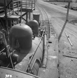
Item
·
Apr. 1966
Part of David Davies Railway Collection
Photograph depicts 6-truck Shay locomotive #114 belonging to the Railway Appliance Company at the Vancouver Wharves Ltd. in North Vancouver. It is used each week.
1996.2.10.46
·
Item
·
[before 2006]
Part of Brian Fawcett fonds
Item is a notebook entitled "70 Anecdotes for Rainbow Trout".
1996.8.1.454
·
Item
·
[1985]
Part of Chander Suri fonds
Gridded aerial plan of agricultural lands from Fraser Lake to Prince George.
2007.1.60.11
·
File
·
1996-1997
Part of Aleza Lake Research Forest fonds
File contains correspondence regarding lack of funding for research projects between the Science Council of British Columbia and Mike Jull, Prince George Forest Region.
Item
·
7/1/1972
Part of Mary Fallis fonds
Sun beginning to set on Takla Lake, Northern British Columbia
2019.10.2
·
File
·
8 Sept. 1969
Part of Lockwood Survey Corporation Ltd. collection
These remote-sensing aerial photographs were taken by Lockwood Survey Corporation Ltd. under contract for the B.C. Forest Service. Some photographs are annotated to show logging activity; clearcuts, slash piles, log booms, and tree debris on the water are also visible in some of the images. No detailed location information or index accompanies the photographs. These historically important aerial photographs depict Williston Lake soon after its creation in 1968 with the building of the W.A.C. Bennett Dam on the Peace River. Also depicted are the rivers and tributaries that empty into the Williston Reservoir, such as the Finlay River, the Ospika River, and the Omineca River.
The identification coding on these photographs can be interpreted as follows:
- The largest number on the leftmost side is the frame number for the individual photograph.
- The following code to the right in the format B) 69-53 is currently unknown, but may refer to an internal project number for the Lockwood Survey Corporation.
- The 6" may refer to the camera's focal length in inches.
- Next is "17,150 ASL" which is 17,150 feet Above Sea Level.
- Following is "152.52" which refers to the camera's focal length in millimeters, which equals 6 inches.
- The "W1307" may refer to the reel, but that is unconfirmed.
- "8 SEP 69" is the date the photos were taken.
2019.10.3
·
File
·
8 Sept. 1969
Part of Lockwood Survey Corporation Ltd. collection
These remote-sensing aerial photographs were taken by Lockwood Survey Corporation Ltd. under contract for the B.C. Forest Service. Some photographs are annotated to show logging activity; clearcuts, slash piles, log booms, and tree debris on the water are also visible in some of the images. No detailed location information or index accompanies the photographs. These historically important aerial photographs depict Williston Lake soon after its creation in 1968 with the building of the W.A.C. Bennett Dam on the Peace River. Also depicted are the rivers and tributaries that empty into the Williston Reservoir, such as the Finlay River, the Ospika River, and the Omineca River.
The identification coding on these photographs can be interpreted as follows:
- The largest number on the leftmost side is the frame number for the individual photograph.
- The following code to the right in the format B) 69-53 is currently unknown, but may refer to an internal project number for the Lockwood Survey Corporation.
- The 6" may refer to the camera's focal length in inches.
- Next is "17,150 ASL" which is 17,150 feet Above Sea Level.
- Following is "152.52" which refers to the camera's focal length in millimeters, which equals 6 inches.
- The "W1307" may refer to the reel, but that is unconfirmed.
- "8 SEP 69" is the date the photos were taken.
2019.10.4
·
File
·
8 Sept. 1969
Part of Lockwood Survey Corporation Ltd. collection
These remote-sensing aerial photographs were taken by Lockwood Survey Corporation Ltd. under contract for the B.C. Forest Service. Some photographs are annotated to show logging activity; clearcuts, slash piles, log booms, and tree debris on the water are also visible in some of the images. No detailed location information or index accompanies the photographs. These historically important aerial photographs depict Williston Lake soon after its creation in 1968 with the building of the W.A.C. Bennett Dam on the Peace River. Also depicted are the rivers and tributaries that empty into the Williston Reservoir, such as the Finlay River, the Ospika River, and the Omineca River.
The identification coding on these photographs can be interpreted as follows:
- The largest number on the leftmost side is the frame number for the individual photograph.
- The following code to the right in the format B) 69-53 is currently unknown, but may refer to an internal project number for the Lockwood Survey Corporation.
- The 6" may refer to the camera's focal length in inches.
- Next is "17,150 ASL" which is 17,150 feet Above Sea Level.
- Following is "152.52" which refers to the camera's focal length in millimeters, which equals 6 inches.
- The "W1307" may refer to the reel, but that is unconfirmed.
- "8 SEP 69" is the date the photos were taken.
Item
·
6/1/1981
Part of Mary Fallis fonds
Lateral detail of <i>Clerodendrum thomsoniae</i> in flower
2016.5.1.59
·
File
·
2000
Part of Harry Coates fonds
File consists of documentation on E.P. 819.06.03.01 Holmes River Half-Sib Progeny Trial.
2016.5.1.60
·
File
·
2000
Part of Harry Coates fonds
File consists of documentation on E.P. 819.08.03.01 Black Birch Creek Half-Sib Progeny Trial.
2014.10.1.033
·
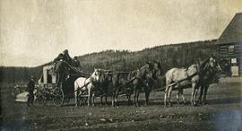
Item
·
1909
Part of Arthur Holland Land Surveying Collection
Photograph depicts a stage coach harnessed with six horses, a fence and a log building in the background.
2009.10.3.50
·
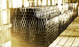
Item
·
[between 1923 and 1926]
Part of Fred Jeffery Photograph Collection
Photograph depicts a large stack of cans. Handwritten annotation below photograph reads, "830 cases of tall cans".
2012.13.3.1.07.15
·
Item
·
29 Apr. 1991
Part of J. Kent Sedgwick fonds
The item is a photograph depicting the side view of a white house located at 886 Vancouver Street, Prince George.
2012.13.3.1.07.17
·
Item
·
29 Apr. 1991
Part of J. Kent Sedgwick fonds
The item is a photograph depicting the garage located at the back of 886 Vancouver Street, Prince George.
2012.13.3.1.07.18
·
Item
·
29 Apr. 1991
Part of J. Kent Sedgwick fonds
The item is a photograph depicting the back of a white house and garage located at the back of 886 Vancouver Street, Prince George.
2012.13.3.1.07.16
·
Item
·
29 Apr. 1991
Part of J. Kent Sedgwick fonds
The item is a photograph depicting the front view of a white house located at 886 Vancouver Street, Prince George.
2001.25
·
Item
·
9 January 1990
Part of Prince George Citizen Collection
Consists of the 9 January 1990 edition of the Prince George Citizen. Front page headline reads as follows : "Here's Our University Plan!" Subheading reads as follows : "Facilities Would Cost $169 Million"
2019.10.5
·
File
·
9 Sept. 1969
Part of Lockwood Survey Corporation Ltd. collection
These remote-sensing aerial photographs were taken by Lockwood Survey Corporation Ltd. under contract for the B.C. Forest Service. Some photographs are annotated to show logging activity; clearcuts, slash piles, log booms, and tree debris on the water are also visible in some of the images. No detailed location information or index accompanies the photographs. These historically important aerial photographs depict Williston Lake soon after its creation in 1968 with the building of the W.A.C. Bennett Dam on the Peace River. Also depicted are the rivers and tributaries that empty into the Williston Reservoir, such as the Finlay River, the Ospika River, and the Omineca River.
The identification coding on these photographs can be interpreted as follows:
- The largest number on the leftmost side is the frame number for the individual photograph.
- The following code to the right in the format "B) 69-53" is currently unknown, but may refer to an internal project number for the Lockwood Survey Corporation.
- The 6" may refer to the camera's focal length in inches.
- Next is "17,150 ASL" which is 17,150 feet Above Sea Level.
- Following is "152.52" which refers to the camera's focal length in millimeters, which equals 6 inches.
- The "W1308" may refer to the reel, but that is unconfirmed.
- "9 SEP 69" is the date the photos were taken.
2019.10.6
·
File
·
9 Sept. 1969
Part of Lockwood Survey Corporation Ltd. collection
These remote-sensing aerial photographs were taken by Lockwood Survey Corporation Ltd. under contract for the B.C. Forest Service. Some photographs are annotated to show logging activity; clearcuts, slash piles, log booms, and tree debris on the water are also visible in some of the images. No detailed location information or index accompanies the photographs. These historically important aerial photographs depict Williston Lake soon after its creation in 1968 with the building of the W.A.C. Bennett Dam on the Peace River. Also depicted are the rivers and tributaries that empty into the Williston Reservoir, such as the Finlay River, the Ospika River, and the Omineca River.
The identification coding on these photographs can be interpreted as follows:
- The largest number on the leftmost side is the frame number for the individual photograph.
- The following code to the right in the format "B) 69-53" is currently unknown, but may refer to an internal project number for the Lockwood Survey Corporation.
- The 6" may refer to the camera's focal length in inches.
- Next is "17,150 ASL" which is 17,150 feet Above Sea Level.
- Following is "152.52" which refers to the camera's focal length in millimeters, which equals 6 inches.
- The "W1308" may refer to the reel, but that is unconfirmed.
- "9 SEP 69" is the date the photos were taken.
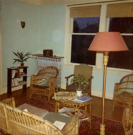
2013.6.36.1.003.037
·
Item
·
[1964?]
Part of David Davies Railway Collection
Photograph depicts the inside of the suite at 925 Cadero St. in the west end of Vancouver, B.C.
2012.13.3.1.07.05
·
Item
·
14 Dec. 1994
Part of J. Kent Sedgwick fonds
The item is a photograph depicting the side view of a green coloured house at 983 Vancouver Street in Prince George.
2012.13.3.1.07.06
·
Item
·
14 Dec. 1994
Part of J. Kent Sedgwick fonds
The item is a photograph depicting the side view of a green coloured house at 983 Vancouver Street in Prince George.
Item
·
7/1/1979
Part of Mary Fallis fonds
Frontal detail of <i>Agoseris</i> in fruit, Northwest Territories [?]
Item
·
4/1/1985
Part of Mary Fallis fonds
Frontal detail of <i>Amaryllis</i>
Item
·
7/1/1979
Part of Mary Fallis fonds
Habitat of <i>Andromeda polifolia</i> in flower, Nunavut
Item
·
6/1/1978
Part of Mary Fallis fonds
[Habit of] <i>Androsace</i> [in flower]
Item
·
8/1/1979
Part of Mary Fallis fonds
Habit of <i>Androsace</i> in white flower with yellow centres
Item
·
7/1/1983
Part of Mary Fallis fonds
Frontal detail of <i>Anemone narcissiflora<i> in flower
Item
·
7/1/1983
Part of Mary Fallis fonds
Frontal detail of <i>Anemone parviflora</i> in flower
Item
·
7/1/1983
Part of Mary Fallis fonds
Yukon Territory
Item
·
8/1/1981
Part of Mary Fallis fonds
Frontal detail of <i>Antennaria</i> [?] in flower, Alaska