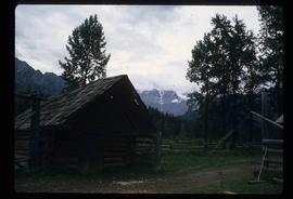
Image depicts the Mount Robson Ranch.
Image depicts a small, ruined shed somewhere in the Okanagan Kettle Valley.
Image depicts a view of Kettle Valley, with a bridge of the old Kettle Valley Rail Road visible on a slope.
Image depicts a woman walking along a trail somewhere in Kettle Valley, B.C.
Image depicts a woman walking along the trail of the Kettle Valley Rail Road.
Image depicts the Okanagan Kettle Valley, with the Kettle Rail Road faintly visible among the trees
Image depicts the trail of the old Kettle Valley Rail Road.
Image depicts the old Kettle Valley Rail Road.
Image depicts a woman standing on the old Kettle Valley Rail Road.
Image depicts a man standing on the old Kettle Valley Rail Road.
Image depicts several unknown individuals standing on the old Kettle Valley Rail Road.
Image depicts a farmhouse on Old Summit Road in Prince George, B.C.
Image depicts the Fraser River and the Grand Trunk Pacific Bridge from Cottonwood Island Park.
Image depicts the Pearson Homestead.
Image depicts a view of Peden Hill in Prince George, B.C.
Image depicts Highway 97 at 15th Ave. looking north. Map coordinates 53°54'36.0"N 122°46'55.5"W
Image depicts Highway 97 at 15th Ave. looking north. Map coordinates 53°54'42.1"N 122°46'53.1"W
Image depicts the Canadian National Railway Yards in Prince George, B.C.
Image depicts a rural setting, most likely near the airport in Prince George, B.C.
Image depicts a few houses, most likely near the airport in Prince George, B.C.
Image depicts mobile homes for sale on Cowart Road looking northeast with Simon Fraser Bridge in background. Map coordinates 53°52'39.3"N 122°46'13.1"W
Image depicts Parkwood Place taken from Connaught Hill looking west with the hospital in the background. Map coordinates 53°54'39.9"N 122°45'02.5"W
Image depicts Prince George from the view of Peden Hill.
Image depicts a gauging tower at Shelley, B.C.
Image depicts a pipeline at Shelley, B.C.
Image depicts a view of Prince George from Carney Hill.
Image depicts downtown Prince George looking northwest across Dominion Street. Map coordinates 53°54'48.7"N 122°44'45.6"W
Image depicts a view of Prince George from City Hall looking northeast with the pulp mills in the background. Map coordinates 53°54'46.3"N 122°44'41.9"W
Image depicts a view of Prince George from City Hall looking northeast along George Street. Map coordinates 53°54'46.3"N 122°44'41.9"W
Image depicts a view of Prince George from City Hall looking north. Map coordinates 53°54'46.3"N 122°44'41.9"W
Image depicts a view of Prince George from Cranbrook Hill looking east. Map coordinates 53°54'51.5"N 122°49'05.2"W
Image depicts a view of Prince George from Cranbrook Hill looking southeast. Map coordinates 53°54'51.5"N 122°49'05.2"W
Image depicts a view of Prince George from Cranbrook Hill looking east. Map coordinates 53°54'51.5"N 122°49'05.2"W
Image depicts a view of Prince George from Cranbrook Hill looking southeast. Map coordinates 53°54'51.5"N 122°49'05.2"W
Image depicts a view of Prince George from Cranbrook Hill looking east.
Image depicts a view of Prince George from Cranbrook Hill looking east with pulpmill and downtown in background.
Image depicts a view of Prince George from Cranbrook Hill looking southeast. Map coordinates 53°54'51.5"N 122°49'05.2"W
Image depicts 3rd Ave at Brunswick Street in -35 degree weather. Map coordinates 53°55'03.0"N 122°44'51.7"W
Image depicts Brunswick Street at 3rd Ave in -35 degree weather. Map coordinates 53°55'03.0"N 122°44'51.7"W
Image depicts the Central Business District of Prince George looking north from Connaught Hill. Map coordinates 53°54'41.4"N 122°44'58.5"W
Image depicts a dog and dog house in the back of a pick-up somewhere near Prince George, B.C.
Image depicts the Prince George Public Library (Bob Harkins Branch). Map coordinates 53°54'43.1"N 122°44'56.4"W
Image depicts the Fort George Regional Museum (now known as The Exploration Place) in Prince George, B.C. Map coordinates 53°54'18.6"N 122°44'09.8"W
Image depicts the Four Seasons Leisure Pool, and the Centennial Fountain in Prince George, B.C. Map coordinates 53°54'48.5"N 122°44'49.2"W
Image depicts the Fort George Park. Map coordinates 53°54'30.2"N 122°43'57.4"W
Image depicts a Bavarian style house at College Heights in Prince George, B.C.
Image depicts a Cariboo Ranch style house at College Heights in Prince George, B.C.