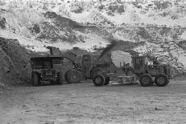
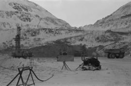
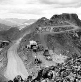
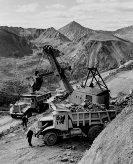
Photograph depicts cable-operated shovel loading Kenworth haul truck on road in mine area at high elevation. Pickup truck in background, four unidentified men are gathered around second Kenworth truck in foreground. Valley and mountain range in distance.
Photograph depicts large dry rock storage building in foreground on right, mill on left behind tailings pile, and dryer building in centre behind conveyor belt connecting mill to dry rock storage. A cloud can be seen rising from plantsite. Trees and Troutline Creek cross foreground, mine valley and mountains visible in background. Stamped annotation on recto of photograph: "ANSCO PRINTON Munshaw Colour Service Ltd. MAR 10 1955".
Photograph depicts bench at 6430 elevation. Blasthole drills, shovels, dozers, and dump trucks can be seen on bench in midground. Mine valley in background. Handwritten annotation on verso of photograph: "1961".
Photograph depicts a crawler cable shovel on right, and bulldozer partially visible on left. Rock face of mountainside in background. Handwritten annotation on verso of photograph: "1961", on recto: "Mining 80 D shovel on [?] 64/70 to 6560 saddle on peak."
Photograph depicts dry rock storage building on left, mill in foreground, and tailings piles behind mill in midground. Mountains in background. Handwritten annotation on verso of photograph: "1961".
Photograph depicts front of dry rock storage building, conveyor visible above on left. Handwritten annotation on verso of photograph: "1961".
Photograph depicts flowing water believed to be Troutline Creek which ran south of Cassiar, B.C. Tailings pile and plant buildings visible behind forest in midground, northern mountain range in background. Handwritten annotation on verso of photograph: "Cassiar June 15 71".
Photograph depicts fenced church building with what appears to be speakers mounted on roof above main entry. Road and trees in foreground, mountains in background. Handwritten annotation on verso of photograph: "Cassiar June 15 71".
Photograph depicts row of houses behind trees. Power line, road, and vehicles in foreground; mountain in background.
Photograph depicts unidentified man walking up front steps to building with the following sign: "TOWN ADMINISTRATION / MOTOR VEHICLE BRANCH / HCBC AGENCY / DISTRICT REGISTRAR / CDN CITIZENSHIP COURT / FISH & GAME LICENCES". Vehicles parked in foreground and behind at unknown building in midground. Power line and mountains in background.
Photograph depicts four orange and brown two-story buildings speculated to be bunkhouse residences. Blue car in foreground, forest and mountains in background.
Photograph depicts two fire trucks semi-visible in garage with the sign "FIRE HALL". House and snowmobile can be seen in left midground, truck and power pole in right foreground. Mountains in background. Warning visible on front of trucks: "KEEP BACK 500m".
Photograph depicts two-story main office building in right midground behind sign reading "CASSIAR ASBESTOS CORPORATION Ltd / CASSIAR MINE / MAIN OFFICE". Building believed to be warehouse can be seen behind raised Canadian flag on pole in left midground. New mill building and tailings pile visible behind warehouse and office, mountains in background.
Photograph depicts the new mine garage behind machinery, mountains in background. Mobile blast hole drill can be seen in left foreground (manufactured by Robbins with Caterpillar undercarriage). Two 50-tonne Wabco "haul paks" in right foreground (ore haulage trucks).
Photograph depicts two unidentified individuals in canoe on Boya Lake, B.C. (formerly known as Chain Lakes). Foliage silhouetted in foreground; forest and hills on opposite shore in background.
Photograph depicts a shovel loading what appears to be a Euclid ore haulage truck on left. Unidentified Caterpillar machine in foreground.
Photograph depicts a Euclid ore haulage truck in foreground. Shovel and unidentified caterpillar machine can be seen in background.
Photograph depicts steel tower. Snow in foreground, mountainside in background.
Photograph depicts tramline conveyor (located west of mine). Conveyor ran from crusher plant to tramline loading station. Mine valley and northwestern mountain range in background.
Photograph depicts William (Bill) Storie at location known as Limestone Mountain, southwest of Cassiar, B.C. Photo features profile of Bill, hands in pocket, Cassiar valley and mountains in background. Storie was a renowned prospector in the Cassiar area, and the new school at Cassiar was named for him in 1992.
Photograph depicts unidentified individual and cars on street in foreground, snow banks, trees, and power poles on either side. Buildings can be seen on far right, mountains visible in background. Handwritten annotation on recto of photograph: "townsite Looking East".
Photograph depicts group of eleven men standing in line in the Cassiar valley. Left to right: Jack Christian, Charles Rainforth Elliot, John Drybrough, John E. Kennedy, Fred Martin Connell, W. Harold Connell, Ken A. Creery, George Washington Smith, Tam Zimmermann, [Fred Murray]?, Nick Gritzuk. Power lines and mountains in background. Most men featured in photo are believed to be members of Cassiar's Board of Directors. Photograph was originally framed with note "Summer 1961" written on cardboard backing.
View of snow capped mountains in the distance, trees and river in mid ground. A Jeep type vehicle is on a bridge in the mid ground with river and sandbar in the foreground. Handwritten annotation on verso in pen reads: “Cassiar Road. Cottonwood River crossing”
Photograph depicts a man and woman standing on what is believed to be an early mining bench. Two men with air track drill can be seen in background, one man father down on left, mountain range in background. Image slightly distorted due to poor quality of negative.
Photograph depicts two men working with air track drill in mine area. Hose and dynamite box in foreground, mountains in background. Handwritten annotation on verso of photograph: "Sept. 1954." This photograph was originally stored inside duotang labeled "CASSIAR ASBESTOS CORPORATION LIMITED PHOTOGRAPHS 1954"; photo caption beneath this image: "Starting New Bench at South end of Deposit."
Photograph depicts unknown man driving bulldozer on edge of mine area at high elevation. The dozer is an International model TD24 (manufactured between 1947 and 1955). A second man stands on edge of cliff, directing driver. Expansive mountain range in background.
Photograph depicts close up view of gravel pit, ruler displayed for scale. Photograph speculated to have been taken at the plant or near the Cassiar airstrip. Stamped annotation on recto of photograph: "JUN. 1987".
Photograph depicts a car and two dump trucks near a small garage by road in mine. One man stands at garage site among tires and miscellaneous tools. Blasthole drills, shovels, and dump trucks visible in distance. Rocks in foreground, mountains in background. Handwritten annotation on verso of photograph: "1961".
Photograph depicts men standing near two Atlas Copco Drillmasters (blasthole drills). These are precision hammer drills which had their own power source. Large bags of ammonium nitrate in foreground, mountaintops in background. The men depicted here were likely members of the explosive crew. It is believed that this photo was taken on the North ridge, near the cirque dump. Handwritten annotation on verso of photograph: "1961".
Photograph depicts tower and bucket tram in left foreground, plantsite in midground, mountains across valley in background. Dry rock storage building, mill, tailings pile, and many other buildings visible in plantsite. Handwritten annotation on verso of photograph: "1961".
Photograph depicts long wood building believed to be the bar and snackbar at Cassiar B.C. Two men can be seen standing on one of three porches to building. Pole, car, and trees in foreground; unknown buildings and mountain base in background. Handwritten annotation on verso of photograph: "1961".
Photograph depicts mine valley and road in foreground. Cassiar plant visible in left midground, townsite in right midground. Southern mountain range in background.
Photograph depicts crusher plant in centre foreground. Shifter shack and vehicles can be seen in front of pit area. West Peak semi-visible in right midground. Mine valley an northwestern mountain range in background.
Photograph depicts plant buildings below, tailings pile in foreground. Valley and mountains in background. Handwritten annotation on recto of photograph: "CASSIAR".
Photograph depicts plant buildings in front of tailings pile in midground. Forest, power line, and tramline in foreground; south mountains in background.
Photograph depicts an unidentified man walking in front of orange and brown two-story building speculated to be bunkhouse residences. Second unknown individual can be seen unloading car in left foreground. Trees and mountains visible in background.
Photograph depicts row of houses on either side of street in midground. Forest trees in foreground, mountains in background.
Photograph depicts the Cassiar mine on McDame Mountain. West peak semi-visible in foreground. Drills and ore haulage trucks visible below in pit and on switchback roads.
Photograph depicts the Cassiar mine on McDame Mountain. Blasthole drills and ore haulage trucks visible below in open pit and on switchback road.
Photograph depicts blasthole drill on left, bulldozer in centre, and shovel loading ore haulage truck in background. Second haul truck is semi-visible on far right. Hose equipment can be seen in foreground.
Photograph depicts a shovel loading what appears to be a Euclid ore haulage truck in excavation area of mine.
Photograph depicts a Euclid ore haulage truck dumping material on pile in left foreground.
Photograph depicts crusher buildings in left foreground, located west of mine on McDame Mountain. Southeast mountain range in background.
Photograph depicts what appears to be a Euclid ore haulage truck at entrance of building speculated to be the truck dumping station at crusher plant in mine.
Photograph depicts ore cars on cables running between tramline towers on left. Road in right foreground, building and McDame mountain in background. Tramline ran through mine valley, between loading station in mine and dump station at mill on plantsite.
Plant buildings stand in midground. Conveyor believed to be leading to tailings pile can be seen in foreground. Valley and mountains in background.
Photograph depicts group of eight men standing in line in the Cassiar valley. Left to right: Charles Rainforth Elliot, John Drybrough, John E. Kennedy, Fred Martin Connell, W. Harold Connell, Ken A. Creery, George Washington Smith, Tam Zimmermann. Power lines and mountains in background.
Overview of a snow covered mountain tops of the Cassiar Mountains. Handwritten annotation on verso in pen reads: “Cassiar mtns.”
Photograph depicts large square model of the new mill building that was built at the Cassiar plant site in 1970. Model is displayed outdoors on a platform that stands on four saw horses. Machinery modeled inside the structure is colour-coded. Plant buildings and mountains in background.
Photograph depicts buildings near West Peak of Cassiar mine. Haul trucks parked near old mine garage in background, new mine garage and unknown buildings in foreground. Mine valley crosses midground, expansive western mountain range in background.