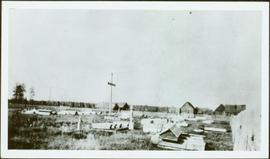
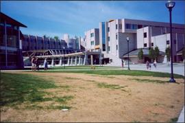
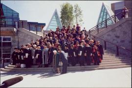
Photograph depicts large group posed on ceremonial steps in Agora courtyard at the University of Northern British Columbia in Prince George, B.C. Most individuals in group wear regalia. Bridget Moran appears to be standing in center of second row, hand raised to her face.
Photograph depicts group of three at stone steps in courtyard at the University of Northern British Columbia, in Prince George, B.C. Photo taken on the day Moran received an Honourary Law Degree. Left to right: Bob Harkins, Bridget Moran, unknown.
Photograph depicts the Agora center at the University of Northern British Columbia in Prince George, B.C. Library building can be seen in right background, cafeteria building on far left. Unidentified individuals can be seen walking on campus. Accompanying note from Maureen Faulkner: "The processional gathers on the upper walkway". Photo believed to have been taken on the day Bridget Moran received an Honourary Law Degree.
Photograph depicts Moran wearing regalia, embraced by her sons Mike (in foreground) and Pat. The group stands in the Agora courtyard at the University of Northern British Columbia in Prince George, B.C. Unidentified individuals stand near Winter Garden in background. Accompanying note from Maureen Faulkner: "Pat gets in on the action!." Photo taken on the day Moran received an Honourary Law Degree.
Includes an audiocassette copy of an interview conducted by Kent Sedgwick with Trelle Morrow on the history of architectural design in Prince George.
Photograph depicts lane in front of tent buildings flooded with water, and a man standing near doorway to first building. It is believed that this photograph may depict the Island Cache in flood, at Prince George, BC.
Left to right: Interior University Society President Murray Sadler, Prince George Mayor John Backhouse, Chancellor Iona Campagnolo, and President Geoffrey R. Weller.
Handwritten annotation on verso reads: “Construction of UNBC”.
Printed annotation on recto reads: “Central Avenue Fort George B.C. Copyright Canada June 25th 1913”. Handwritten annotation in ink on recto reads: “Hotel Fort George; Pool room; Men’s furnishing; General store; Bank Vancouver; Telephone office; Temperance House; Trust-company; Grand stand & fair grounds; Hospital; Ware house and general store.” Cancelled 1 cent Canadian stamp on verso is dated: "Fort George BC Jul 14 13". Handwritten message in ink on verso is addressed to Mr. Chas H Wilson 94 Gould St Toronto: "Fort George. B.C> Box 65, July 13/ 13. Dear Father, This is a 'bird's eye view' of our main street - ha! ha! some class alright. We live right behind the bakery lunch room on the right hand side of the picture, on 1st avenue, some people eh? Will be moving to Cassiar Ave soon. How are all the folks. Mae is writing. Peace. M."
Boardwalk in foreground, buildings and roads in mid ground, cut banks in background. Printed annotation on recto reads: “Prince George. B.C. 1921 by Moore”. Handwritten annotation in ink on verso reads: “The Netchaco river is between the mountain and the city and the C.N.R. runs along the river bank nearest the city. This picture is taken looking north.”
Street scene in Prince George B.C. Several Union Jack flags are visible and there is a celebration banner at the end of the street. Long shadows in photo indicate summer (perhaps Dominion Day?). River in foreground, railroad and city in mid ground and hill in background. Printed annotation on recto reads: “Prince George. B.C.”
Street view photograph of a commercial section in downtown Prince George with several "Campbell's" delivery carts parked along the road. Visible establishments include "Campbell's All Cash Store" and "Club Cafe." Handwritten annotation in blue ballpoint pen on recto reads: "Howdy from Prince George! Going easy with all these kids- good to see Kathee. Snow here. Have fun at the sports show & don't over do it. Thinking of you guys, love Judy and Vic. P.S. Can't wait to go home to somewhere peaceful and quiet. 2-27-83." Postcard is addressed to: "Mr. & Mrs. Hauffer 8429-221 PL. Sn. Edmonds, WA. U.S. 98020." Verso is affixed with four Canadian 8-cent stamps.
Side view of a wooden church, possibly under construction, and other buildings. Printed annotation on recto reads: "Indian Village- Prince George."
Street view of some vehicles parked in front of commercial buildings in Prince/Fort George. Businesses include "J.P. Robertson 'The Men's Store'" and "James & Co. Clothing and Shoes." Printed annotation on recto reads: "Fort George- Corner Hammond and Central."
Street level photo of George Street in Prince George. Visible businesses include "B-A" and "Astoria Hotel." Printed annotation on recto reads: "George St. Prince George."
Photograph depicts landscape with cleared land in foreground, river in middle, building and trees in background.
Handwritten annotation on verso: "Central Fort George 1911".
Early spring landscape with roadbed and track in foreground, river in midground, and hill in background.
Handwritten annotation on recto: “PRINCE GEORGE 4-20-13”.
Photograph depicts large three story building, road and parked cars in foreground.
Annotation on verso: “Court House and Prov. Govt. offices at Pr. George. Once used to be 'Alexandra Hotel' now site occupied by Kresge’s. Alexander Hotel. Opened Sept 25, 1915."
Photograph depicts rows of grave markers in foreground, fence and buildings in background.
Handwritten annotation on verso “Indian cemetery, Reserve #1 South Fort George".
Photograph depicts two connected buildings; the building on the left is possibly the theatre, other building with sign that reads: "The Nechaco (sic?) General Stores." Boardwalk with people and unpaved street in foreground.
Image depicts a Beehive Burner along the Nechako on River Road. Map coordinates 53°55'34.1"N 122°44'58.0"W
Image depicts a saw cutting a log in half at a saw mill in Prince George, B.C.
Image depicts a large saw at an indoor location, likely in a saw mill somewhere in Prince George, B.C.
Image depicts the interior of a saw mill somewhere in Prince George, B.C.
Image depicts two unidentified individuals examining a thick log still attached to the machine that cut it down. It is located somewhere in Prince George, B.C.
Image depicts several pieces of heavy machinery used in forestry. The Coast Inn of the North is seen in the background.
Photograph depicts a residential building at 1601 6th Avenue, the corner of 6th Avenue and Vancouver Street. Annotation on verso: "CUTE c-7, union, Vancouver/ 6th".
Photograph depicts a residential building at 1648 8th Avenue. Annotation on verso: "1648 - 8th, next to Rosel's".
Photograph depicts a residential building at 1625 4th Avenue. Annotation on verso: "Loedel proposal, 1625 - 4th, (see above)".
Photograph depicts a residential building on the corner of Vancouver Street and 10th Avenue. Annotation on verso: "Trick house, Vancouver/ 10th".
Photograph depicts a residential building at the corner of 6th Avenue and Winnipeg Street. Annotation on verso: "NE corner, 6th / Winnipeg".
Photograph depicts the Europe Hotel on 3rd Avenue.
Photograph depicts the old post office and federal government building at 1299 3rd Avenue prior to the coat of arms removal. Annotation on verso: "fed. govt bldg, (post office), c. 1990, before, coat of arms, removal".
Photograph depicts a parking lot and alleyway behind the Europe Hotel on 3rd Avenue.
Photograph depicts a Rental and repair shop on 3rd Avenue.
Image depicts the Pearson Homestead.
Image depicts a rural setting, most likely near the airport in Prince George, B.C.
Image depicts a view of Prince George from Carney Hill.
Image depicts a view of Prince George from City Hall looking northeast along George Street. Map coordinates 53°54'46.3"N 122°44'41.9"W
Image depicts a view of Prince George from City Hall looking north. Map coordinates 53°54'46.3"N 122°44'41.9"W
Image depicts a view of Prince George from Cranbrook Hill looking southeast. Map coordinates 53°54'51.5"N 122°49'05.2"W
Image depicts a view of Prince George from Cranbrook Hill looking east. Map coordinates 53°54'51.5"N 122°49'05.2"W
Image depicts a view of Prince George from Cranbrook Hill looking southeast. Map coordinates 53°54'51.5"N 122°49'05.2"W
Image depicts a view of Prince George from Cranbrook Hill looking east with pulpmill and downtown in background.
Image depicts Brunswick Street at 3rd Ave in -35 degree weather. Map coordinates 53°55'03.0"N 122°44'51.7"W
Image depicts the Central Business District of Prince George looking north from Connaught Hill. Map coordinates 53°54'41.4"N 122°44'58.5"W
Image depicts the Fort George Park. Map coordinates 53°54'30.2"N 122°43'57.4"W
Image depicts a Bavarian style house at College Heights in Prince George, B.C.
Image depicts downtown Prince George looking northwest. Map coordinates 53°54'48.7"N 122°44'45.6"W
Image depicts a view of Prince George from City Hall looking northeast along George Street. Map coordinates 53°54'46.3"N 122°44'41.9"W