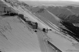
Photograph depicts large dry rock storage building on left, mill in background, dryer building on far right. Road and power poles cross foreground, mountains stand in background. Photo caption next to printed copy of image in 1953 Annual Report: "Completed dry rock storage and dryer buildings."
Photograph depicts red truck dumping waste at what is believed to be the tailings pile at the Cassiar plant. Small building and unidentified individual in bottom left foreground, valley and mountains in background. Photo caption next to printed copy of image in 1953 Annual Report: "Stockpile of 80,000 tons of Ore at Mill."
Photograph depicts large dry rock storage building in foreground on right, mill on left behind tailings pile, and dryer building in centre behind conveyor belt connecting mill to dry rock storage. A cloud can be seen rising from plantsite. Trees and Troutline Creek cross foreground, mine valley and mountains visible in background. Stamped annotation on recto of photograph: "ANSCO PRINTON Munshaw Colour Service Ltd. MAR 10 1955".
Photograph depicts large dry rock storage building in foreground on left, mill in background, dryer building in right midground. Miscellaneous supplies in far right foreground, mountains visible in background. Handwritten annotation on verso of photograph: "Sept 1954". This photograph was originally stored inside duotang labeled "CASSIAR ASBESTOS CORPORATION LIMITED PHOTOGRAPHS 1954"; photo caption beneath this image: "40,000 Ton Dry Storage Building / Mill / Dryer Building".
Photograph depicts three men fishing from shore. Water and trees in background. Left to right: Jack Christian, Plato Malezemoff, Tam Zimmermann.
Photograph depicts three men with fishing gear. Trees and mountains in background. Left to right: Plato Malezemoff (holding fish), Jack Christian, Tam Zimmermann.
Photograph depicts benches of Cassiar's open mine. Men can be seen standing near machinery speculated to be blasthole drills in bottom left of image. Handwritten annotation on recto of photograph: "Waste Stripping Operations on McDame Mt. Ore Mining in lower right Corner.", on verso: "1961".
Photograph depicts ore haul truck at dump in mine, mountain range in background. Photo also features driver and a second unidentified man standing in front of truck. Handwritten annotation on recto of photograph: "Int. Harvester Payhauler Model 95 dumping stripping waste at 6565 Elevation", on verso: "1961".
Photograph depicts ore haul truck at dump in mine, driver visible, mountain range in background. Handwritten annotation on recto of photograph: "Kenworth - Model 802 dumping stripping waste at 6565 Elevation", on verso: "1961".
Photograph depicts Ross Duddy with back to photographer, working at table in lab. Unidentified woman stands in right foreground operating unidentified machinery. Miscellaneous equipment and supplies throughout. Handwritten annotation on recto of photograph: "ROSS DUDDY / LAB SUPER".
Photograph depicts man [possibly Paul Clark?] seated with two women at table in lab. Second man [possibly Lab Superintendent Ross Duddy?] seated at table in background. Miscellaneous equipment and supplies throughout. Handwritten annotation on recto of photograph: "Paul Clark / [Odett?] Cario".
Photograph depicts two women seated at lab table, facing away from photographer. Woman on right believed to be combing asbestos fibres to determine length and grade. Woman on left believed to be conducting standard lab tests (weighing filters, test tubes, or fibres).
Photograph depicts group of ten men standing and kneeling in front of BE 40R blasthole drill in mine area. For names of individuals, see similar image, item 2000.1.1.3.19.72.
Photograph depicts group of ten men standing and kneeling in unknown location at the Cassiar mine. Handwritten annotation on recto of photograph: "APPROX 1965 / BACK L-R / 1.- / 2. Don Erwin [i.e Irwin] / 3. MAC MAcCLOUD DIED 1979 / 4. JIM MURDOCK MINE SUPER / 5. RUPERT McKENZIE CAPT / 6. DANNY DEMETRI / 7. VIC SARAKOSKI / FRONT. L-R / 1. DON HUDGEON / 2. MIKE CLARK / 3. - [Adrian VanHill Sr.]". Information in above annotation supplemented with insight from individuals who contributed to Northern BC Archives Facebook Photo ID Project, contact archivist for more information in research file pertaining to this photograph.
Photograph depicts mine valley and road in foreground. Cassiar plant visible in left midground, townsite in right midground. Southern mountain range in background.
Photograph depicts unidentified woman using Bauer Mcnett machine to test length of fibre samples by using water. Woman stands facing wall, away from photographer, unidentified equipment on either side.
Handwritten annotation on recto of photograph: "Bill Giachino & 'Sam' June 1970 / #4 / 74% / by Tom Kiefer".
Photograph depicts truck at reject plant in foreground. Mine road can be seen leading to plant in centre background, town in right background. South mountain range visible in distance. Handwritten annotation on recto of photograph: "June 1970 / Looking South across Rock Reject Tailings / Note Southern direction of conveyor [?] towards No 1 Gully. Tom Kiefer".
Photograph depicts benches from strip mining operations at the Cassiar mine. Haul trucks and equipment believed to be used for explosive purposes can be seen in mine. Shop and mountain range visible in background. Handwritten annotation on recto of photograph: "Cassiar, BC / June 1970 / by Tom Kiefer". Image consists of three photographic prints adhered together to form one comprehensive panoramic.
Photograph depicts colour-coded model of mine in display case. Legend partially legible in image: "TALUS / VOLCANICS / WASTE SERPENTINE / AAA ORE / AA ORE". Handwritten annotation on recto of photograph: "Cassiar B.C. June 1970 by Tom Kiefer".
Photograph depicts flowing water believed to be Troutline Creek which ran south of Cassiar, B.C. Tailings pile and plant buildings visible behind forest in midground, northern mountain range in background. Handwritten annotation on verso of photograph: "Cassiar June 15 71".
Photograph depicts yellow daffodils planted in dirt outside of main office building. Handwritten annotation on verso of photograph: "Cassiar June 15 71".
Photograph depicts flowing water believed to be Troutline Creek which ran south of Cassiar, B.C. Tailings pile and plant buildings visible behind forest in midground, northern mountain range in background. Handwritten annotation on verso of photograph: "Cassiar June 15 71".
Photograph depicts flowing water speculated to be Troutline Creek which ran south of Cassiar, B.C. Forest on opposite shore and mountains in background. Handwritten annotation on verso of photograph: "Cassiar June 15 71".
Photograph depicts crusher plant in centre foreground. Shifter shack and vehicles can be seen in front of pit area. West Peak semi-visible in right midground. Mine valley an northwestern mountain range in background.
Photograph depicts plant buildings below, tailings pile in foreground. Valley and mountains in background. Handwritten annotation on recto of photograph: "CASSIAR".
Photograph depicts plant buildings in front of tailings pile in midground. Forest, power line, and tramline in foreground; south mountains in background.
Reclamation is the process of recovering disturbed land to its former state or other productive uses. This collection of photographs depicts men at work instituting a project on the control of erosion and to restore the mined areas to a condition in keeping with the environmental standards.
Photograph depicts the West Peak of the Cassiar mine on McDame Mountain. Pit area visible between West Peak and road in foreground. Mine valley and north mountain range in background. Photo speculated to have been taken from a point on or near the South or North Peak.
Photograph depicts mine valley and road in foreground. Cassiar plant and tailings pile visible in left midground, townsite in right midground. Mountainside of McDame Mountain in foreground, southern mountain range in background.
File contains photographs featuring the tramline at Cassiar which ran from the crushing plant at the mountain mine to the plantsite in the valley (a drop of 427 meters). The first ore was originally transported by truck to the plant until the gravity chute was built in 1953. This chute was replaced with the first aerial tramline model in 1956, which was succeeded by the second model in 1975. This file also includes one photo of the original gravity chute, and one photo depicting a tramline worker.
Additionally there is a collection of eighteen photographs of tramline cars that were being surveyed for damage and condition, and another collection of six photographs of tramline study. The results of this study determined that there was variances in load sizes of the buckets caused by extra material falling off the panfeeder.
Photograph depicts shovel in excavation area of mine, loading ore haulage truck believed to be a Wabco "haul pak".
Photograph depicts two unidentified individuals in canoe on Boya Lake, B.C. (formerly known as Chain Lakes). Foliage silhouetted in foreground; forest and hills on opposite shore in background.
Photograph depicts a shovel loading what appears to be a Euclid ore haulage truck on left. Unidentified Caterpillar machine in foreground.
Photograph depicts a Euclid ore haulage truck in foreground. Shovel and unidentified caterpillar machine can be seen in background.
Photograph depicts unidentified man standing in change house located at the new Mine Dry building. This change house utilized baskets which could be lowered under hinged covers, while the previous change house used baskets which could be raised by chains.
Photograph depicts mine area. Switchback road and higher benches in background. Blasthole drills, track shovels, and ore haulage trucks can be seen on level in foreground and higher bench in background. Mountains visible in distance. Benches in background speculated to be located on the mine's West Peak.
Photograph depicts wheel bulldozer in snowy unknown area of mine.
Photograph depicts machinery in snowy area of mine. Euclid ore haulage truck in foreground, cassiar pickup truck visible in lower area in midground. Blasthole drill in front of track shovel in left background, Wabco ore haulage truck visible behind other machinery in right background.
Photograph depicts part of the vacuum dust control and removal system in the Cassiar mill building. Unidentified man can be seen at rotary air-lock, in which heavy blown dust would collect before dropping to plenum conveyor resting just above floor. From here, the dust would eventually be expelled at the tailings pile outside of the mill. Second unidentified man can be seen climbing steps in background. This section of the mill was located above the lab.
Photograph depicts Zora Ivanovska in safety gear, vaccuming asbestos dust from "hall screen" in mill (slanted vibrating tables with varying mesh sizes, used to separate different lengths of fibre). Mill General Foreman Tony Pinto is visible on far right, with unidentified man.
Photograph depicts three women wearing white aprons while conducting tests on asbestos fibre in lab area, miscellaneous equipment throughout room.
Photograph depicts the Cassiar mine on McDame Mountain. West peak semi-visible in foreground. Drills and ore haulage trucks visible below in pit and on switchback roads.
Photograph depicts the Cassiar mine on McDame Mountain. Blasthole drills and ore haulage trucks visible below in open pit and on switchback road.
Photograph depicts blasthole drill on left, bulldozer in centre, and shovel loading ore haulage truck in background. Second haul truck is semi-visible on far right. Hose equipment can be seen in foreground.
Photograph depicts a shovel loading what appears to be a Euclid ore haulage truck in excavation area of mine.
Photograph depicts a Euclid ore haulage truck dumping material on pile in left foreground.
Photograph depicts crusher buildings in left foreground, located west of mine on McDame Mountain. Southeast mountain range in background.