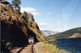
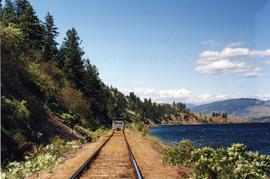
The item is a photograph depicting low water levels and the dried riverbed on the Fraser River.
File consists of notes, clippings, and reproductions relating to Frank Swannell, who was a surveyor in British Columbia that surveyed many areas across the province between 1898 and 1908.
The item is a 35 mm photograph negative of a photograph depicting Prince George's City Hall circa. 1922 . The building is approximately two stories high. There is an artillery cannon next to the building. The refection of the photographer is slightly visible in the photograph.
The item is a photograph reprint originally taken between 1967 and 1975. The photograph depicts the exterior front and parking lot side of Prince George City Hall prior to its three story expansion in 1975. The address is 1100 Patricia Boulevard
The item is a photograph reprint originally taken between 1967 and 1975. The photograph depicts the parking lot and side exterior of Prince George City Hall prior to its three story expansion in 1975. An unknown white commercial building can be seen in the background. The address is 1100 Patricia Boulevard.
The item is a photograph reprint originally taken between 1967 and 1975. The photograph depicts the parking lot and side exterior of Prince George City Hall prior to its three story expansion in 1975. The address is 1100 Patricia Boulevard.
The item is a photograph reprint originally taken between 1967 and 1975. The photograph depicts the exterior parking lot side of Prince George City Hall prior to its three story expansion in 1975. The address is 1100 Patricia Boulevard.
The item is a photograph reprint originally taken between 1967 and 1975. The photograph depicts the front of Prince George City Hall prior to its three story expansion in 1975. The war memorial cenotaph can be seen in front of the building. The address is 1100 Patricia Boulevard.
The item is a photograph reprint originally taken between 1967 and 1975. The photograph depicts the exterior parking lot side of Prince George City Hall prior to its three story expansion in 1975. The address is 1100 Patricia Boulevard.
The item is a photograph reprint originally taken between 1967 and 1975. The photograph depicts the back and side exterior of Prince George City Hall prior to its three story expansion in 1975. The picture is taken across the street. The address is 1100 Patricia Boulevard.
The item is a photograph reprint originally taken between 1967 and 1975. The photograph depicts the back and side exterior of Prince George City Hall prior to its three story expansion in 1975. The address is 1100 Patricia Boulevard.
The item is a photograph reprint originally taken between 1967 and 1975. The photograph depicts the front and side exterior of Prince George City Hall prior to its three story expansion in 1975. The address is 1100 Patricia Boulevard.
The item is a computer diskette including various word document versions of articles written by Kent Sedgwick. Annotation on the diskette states, "J. Kent Sedgwick Caledonia article and bibliography Word versions."
File consists of notes, clippings, and reproductions relating to the Giscome Farm Ltd. File also includes photographs depicting the Giscome Farm.
Photograph depicts a Sperry Rail Service inspection car that had broken down in the CPR Kamloops yard. Car #127 was built in 1927 as a gas electric car for Boston and Maine R.R. It was modernized in 1989.
Photograph depicts CPR cabooses in Revelstoke.
Photograph taken from a speeder at the Lumby Junction. The two visible sidings held trains awaiting departure to Kelowna or Kamloops.
Photograph taken on mile 90, with Kalamalka Lake at the right.There were very sharp curves in this area.
Photograph depicts a model of a Fairmont track motor of the 1960's.
Photograph depicts a model of a Fairmont track car that was presented to Giovanni Marra in 1973 and built by L.G. Snowden.
Photograph depicts a one-tenth scale model of a Fairmont track vehicle. Presented to Giovanni Marra in 1973.
Photograph depicts a speeder meet while on a B.C. run from Armstrong to Campbell Creek Junction and back again. About 25 cars were at the south end of Monte Lake.
Photograph depicts a speeder meet of "Motor Car Operators West" enthusiasts. Comprised of 25 cars. All taking part in a weekend tour of the Okanagan. On this day, they were going from Vernon to Lumby and Kelowna. Cars were getting ready to depart at the yard of the Kelowna Pacific Railway in Vernon. The cars were headed south to be preceeded by hi-rail of the KPR.
Photograph depicts the Kelowna Pacific Ralway yard in Vernon, near the CNR Okanagan Subdivision.
Photograph taken on the Kelowna "main" line, which was perhaps half of a mile south of the Lumby Junction on the very outskirts of Vernon.
Photograph taken on the shores of Kalamalka Lake.
Photograph taken on the outskirts of Kelowna, in an industrial area about 2 miles north of a branch terminal. The turn around point for all 25 speeders was done on a black-topped, little used public grade crossing.
Photograph taken at the Kekuli Bay Provincial Park and boat launch. Image captures the view of all 25 speeders on an Okanagan tour of "Motor Car Operators West" (a U.S. group with western Canadian additions). On this segment, Davies travelled in the fifth speeder from the front.
Photograph depicts a BC Rail passenger train that had stopped to let passengers board at Exeter Station. Jobs were being lost as a result of the cessation in passenger traffic.
Photograph depicts a three times weekly southbound train.
Photograph depicts a Northwestern Pacific speeder.
Photograph depicts a pump car that was property of Kamloops Heritage Railway. Viewed at the downtown CNR station in Kamloops.
Photograph depicts a tool house on a CNR curve in Armstrong. Not in frequent use.
Image depicts a house made from a rail car in an uncertain location. It could be in Hixon, Red Rock, or Woodpecker, B.C.
Image depicts a farm likely in Woodpecker, B.C.
Image depicts a house made from a rail car in an uncertain location. It could be in Hixon, Red Rock, or Woodpecker, B.C.
Image depicts a creek near Iron Road North, north of Woodpecker, B.C.
Image depicts a ditch near a road somewhere in Woodpecker B.C.
Image depicts a pair of dogs in a forest, possibly somewhere near Woodpecker, B.C.
Image depicts a forest, possibly somewhere near Woodpecker, B.C.
Image depicts a tree line in Woodpecker, B.C.
Image depicts a cabin somewhere in Mud River, B.C.
File consists of correspondence, meeting minutes, and pamphlets regarding the work of the Grasslands Conservation Council of British Columbia.
File consists of records created and accumulated by Gary Runka over the course of his consultancy work for BC Ministry of Sustainable Resource Management for the "Morice LRMP Issues, Concerns and Progress Design Report" project in Houston. This file was numbered as G.G. Runka Land Sense Ltd. client file #573; that client number may be seen referenced elsewhere in the G. Gary Runka fonds. The Land Sense Ltd. client files generally include records such as correspondence, contracts, invoices, project reports, publications, ephemera, memoranda, maps or map excerpts, legal documents, meeting materials, clippings, and handwritten notes.
Includes the following:
- Morice Planning Area Background Report: An Overview of Natural, Cultural, and Socio-Economic Features, Land Uses and Resources Management. Prepared by H. Horn & G.C. Tamblyn for Prince Rupert Interagency Management Committee. Smithers. 2000.
File consists of records created and accumulated by Gary Runka over the course of his consultancy work for Land Reserve Commission for the "Preparation, Consultation and Presentation of New Commissioner Training Workshop" project in Burnaby. This file was numbered as G.G. Runka Land Sense Ltd. client file #574; that client number may be seen referenced elsewhere in the G. Gary Runka fonds. The Land Sense Ltd. client files generally include records such as correspondence, contracts, invoices, project reports, publications, ephemera, memoranda, maps or map excerpts, legal documents, meeting materials, clippings, and handwritten notes.