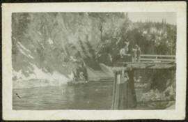
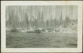
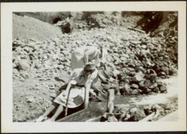
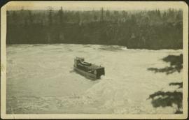
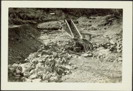
Photograph depicts a large structure in center of mining area in riverbed, equipment and supplies scattered throughout. Buildings and forest in background. Handwritten annotation on verso of photograph: "Spruce Creek, Lower Shovel Workings 6/25/39.", on recto: "Atlin".
Photograph depicts two unidentified men standing on wood walkway extended high above water. Cliffs in background. Photograph speculated to have been taken at Sayer Creek, B.C.
Photograph depicts river and shore in foreground, hills on opposite shore in background. Handwritten annotation on recto of photograph: "Finlay Forks."
Photograph depicts two log buildings in fenced area on lake shore, forest trees in background. A man can be seen standing near docking area and small boat pier extending into water in foreground. Handwritten annotation on recto of photograph: "Fur Farm Red Rock Lake". This location is believed to at mile 27, north of Summit Lake.
Photograph depicts a team of dogs pulling a sled and an unidentified person across a very flat area under heavy clouds. Mountains in background. Handwritten annotations on verso of photograph: "Unbroken Trails", "Taylor". Photograph speculated to have been taken near Atlin, B.C.
Photograph depicts aerial view of unknown river winding through forest.
Photograph depicts Pine Creek winding through forest and hills. Altin Lake and mountains in background. Handwritten annotation on recto of photograph: "Atlin: Looking down lower Pine Ck, westerly towards Atlin, Atlin Lk, & the Atlin Mts. (part of Coast Range)."
Photograph depicts trees on water shore, lake in foreground, mountain in background. See also item 2009.5.2.80.
Photograph depicts trees on water shore, lake in foreground, mountain in background. See also item 2009.5.2.79.
Photograph depicts men and haul trucks visible in distance on snowy road in tree-covered hills.
Photograph depicts an unidentified river flowing through snowy area, trees on left, hill on right. Barbed wire fence crosses foreground.
Photograph depicts river in foreground, trees on opposite shore in background. Photo also appears to depict two unidentified individuals on small boat or canoe.
Photograph depicts thick forest in foreground, cliffs in distance.
Photograph depicts unidentified river flowing through hills, trees in foreground, mountains in background.
Photograph depicts railroad tracks along unidentified river or lake. Trees and grass in foreground, opposite shore in background.
Flat grass-covered area in foreground.
Sarah Glassey stands behind woman seated on ground, lake and hills in background.
Unidentified woman stands with umbrella in public area on waterfront. Water crosses midground, opposite shore and mountain in background.
Three unidentified women lean over flowing stream in area speculated to be a mining location. Sluiceway appears to be visible in foreground.
Men stand beside traffic light by the merge of two railway tracks. Shed and train car stand in midground, water and opposite shore in background.
Group of eleven men and women stands and kneels in front of fence, field and hills in background. Sarah stands fourth from left, Bert stands on far right. Handwritten annotation on recto of photograph: "Murphy's place ATLIN." Similar group also featured in items 2009.5.2.274 - 2009.5.2.294.
Photograph depicts tree-covered cliffs on opposite shore, river in foreground.
Photograph depicts three men standing with oars in small boat, forest slash at their feet. More slash lies in foreground behind bushes and plants on swampy shore. Trees in background. These men are believed to be members of the Bourchier forestry crew.
Photograph depicts an empty canoe floating directly in front of small white tents on opposite shore. Forest trees in background.
Photograph depicts one woman with her back turned, and four men standing on scow next to chairs and table adorned with food. Trees on shore in background. Handwritten annotation on recto of photograph reads: "Bourchier Scow".
Photograph depicts settlement across frozen lake. Trees cross midground, mountains stand in background. Handwritten annotation on verso of photograph reads: "Distant view of Tete Jaune B.C.", on recto of photograph: "I marked about where you loaded your boat the telephone pole is down the road toward 53. Tete Jaune Mile 52."
Photograph depicts four men and small cart standing in street, lines of log buildings on either side. Tents can be seen at end of left side of street. First building on left is larger, with the sign "STOPPING PLACE". Trees cross midground, mountains stand in background. Handwritten annotation on verso of photograph reads: "Tete Jaune Cache. B.C."
Tree branches in right foreground, and forest above banks on opposite shore in background.
Photograph depicts a train and long building on high level of river bank. Fraser river in foreground, forest trees on shore in background.
Photograph depicts men on river scow in distance. Rocks in foreground, trees and cliffs on opposite shore in background. Handwritten annotation on verso of photograph: "Scow in Upper Grand Canon. Fraser River. B.C.."
Photograph depicts two men believed to be North-West Mounted Police officers standing on either side of white packhorse. Forest and mountains in background. Photograph may have been taken in Vanderhoof, B.C.
Officers are mounted on three horses standing in water. Fifth horse stands on right, trees on shore in background. Handwritten annotation on recto of photograph: "Jas Tracey, Vanderhoof. Srg. Birch."
Photograph depicts Bill and canoe on sandy shore, river and opposite shore in background. Handwritten annotation on recto of photograph: "Billy Barnett at Giscome Portage."
Photograph depicts men on river boat and small canoe floating just off shore. Men sit and stand on shore among square bales and large cut lumber. Forest in background. Handwritten annotations on recto of photograph: "Fort Fraser wooding up at Giscome Portage", "Chilco at Giscome Portage".
Fred and Alan are being pushed in wheelbarrow by a woman wearing a blouse, dress pants, and sunglasses. Typed annotation on recto of photograph: "This is 'Mac' - she is a young woman." This woman is speculated to be Tom Taylor's wife Marion. They stand in a field with a car behind them. A forest and body of water can be see in background, as well as the opposite shore.
Mountains visible in background.
A woman stands in distance on a road with high snowbanks and trees on either side. A dog can be seen in foreground, facing woman. A fence and other structures stand in midground. Tree-covered slope in background.
Forest and mountain visible in background.
Handwritten annotation on slide casing reads: “behind hotel Costa do Sol”.
Photograph is one of seven images believed to have been taken on a Canadian University Service Overseas (CUSO) mission in Mozambique; see also items 2009.6.1.483 - 2009.6.1.489.
Photograph is one of seven images orginally included within a diary dated 12-22 November 1987. Photos depict a day to day account of Canadian University Service Overseas (CUSO) mission to establish whether or not a Canadian presence is justified in the fight against Apartheid and for the liberation of Namibia within a Soviet Sphere Socialist State. See also items 2009.6.1.490 - 2009.6.1.495.
Trees in foreground, hills in background. Unidentified man stands on far left.
Photograph is one of 11 images taken during a World Health Organization (WHO) trip, Human Rights of Women and Children, Peru, 1990. Possibly affiliated with World Council of Churches, International Ecumenical Delegation to Lima, Peru, 14-25 October 1990. See also items 2009.6.1.505 - 2009.6.1.515.
Handwritten notation affixed to verso reads: "Iona w/ Lee Morrison (late) director of First Nations Centre at that time. Soda Creek / net fishing for elders".
Photograph was taken during the chancellor's tour of Xats'ull Heritage Village, Soda Creek First Nation, Williams Lake, B.C.
Left to right: Deborah Poff, Dennis Macknak, Charles Jago, an unidentified woman, Iona Campagnolo, an unidentified man, Ellen Facey, and an unidentified woman. Unknown man stands on lower deck in foreground. Mountains visible in background. Photograph taken during the Chancellor's 1996 regional tour through Atlin and Whitehorse; see also items 2009.6.1.578 - 2009.6.1.581.
Handwritten annotation on verso reads: "#3 Chancellor's Tour".
Trees and town can be seen from balcony, and mountains are visible across water in background. Handwritten annotation on verso reads: “Aug 2006, Her Honor, Dorothy Grant & Carole Sabiston”.
Handwritten annotations on verso read: “Lawn Pool, Memorial, West Coast, VI, Summer ’06,” and “Sept. 15, 2006”.
An 'X' is marked in ink on forest in centre.
The Lieutenant Governor stands next to bridge and highway at top of image, cliffs and white water rapids visible below.
Handwritten notation affixed to verso reads: “Now Reflections in B.C.”
Photograph depicts a Kwakiutl petroglyph in Fort Rupert near Port Hardy. Handwritten annotations on verso reads: “Reversed negative, dry rock, 1957”; “Dry Rock, 1957”
Photograph depicts three young, First Nations girls standing in front of a memorial totem pole with houses and a forested environment visible in the background. Photographer’s stamp on verso: “W.E. Nicholson, 268 E. 10th, Vancouver 10, B.C.”