Men working among lumber at crusher building site, various materials scattered throughout. Vertically protruding planks from framework of crusher building are in foreground. Tree-covered valley in background. Construction of a long structure near the edge of the excavation area can be seen in midground; this is speculated to be the section of the crusher building which housed conveyor "B".
Handwritten caption beside this photo reads: "Lunchroom Damaged by Boulder". Large boulder stands to right of small building, walls of right corner partially destroyed. Lumber, upturned saw horse, and various other material lie on ground. Dirt road in foreground, mountainside in background.
Blue sky in background.
Handwritten caption beside this photo reads: "Elaborate barricades required due to amount of loose rock falling continuously". Three men work in area confined by barricades made of vertical metal rods and horizontal wood planks. Miscellaneous building material and supplies cover the ground. Rock pile in foreground on right.
Photograph depicts a construction worker carrying a plank of lumber across a higher level area of the construction site, semi-constructed walls below him. Barricades against loose rock are semi-visible in foreground (see item 2000.1.1.2.352).
Three men work in area confined by barricades made of vertical metal rods and horizontal wood planks (see item 2000.1.1.2.352). Two ladders in foreground, (one being used by construction worker). Lumber and semi-finished walls can be seen at higher level of elevation in background.
Photograph depicts the Cassiar townsite in foreground. Mill, dry rock storage building, and tailings pile can be seen in background. Handwritten annotation on verso of photograph: "1958 [1961 crossed through]."
Photograph depicts the Cassiar plantsite in foreground, including the mill, dry rock storage building, tailings pile, and many other buildings. Townsite in midground, mountains in background. Handwritten annotation on recto of photograph: "Cassiar."
Photograph depicts the mine road in valley below bulldozer parked on edge of mountain. Cassiar plant and town visible in distance, south mountains behind them in background. Photo also depicts what appears to be a cloud rising from the tailings pile in plantsite.
Photograph depicts the primary crushing plant in foreground. Mine road can be seen below, and plant is visible in distance. South mountains in background. Handwritten annotation on recto of photograph: "1961-1962".
Photograph depicts the mine road in valley bellow mine. Cassiar plant and tailings pile in foreground. Handwritten annotation on recto of photograph: "Oct. 25 / 65 4:25 PM."
Photograph depicts the Cassiar mine after extensive strip mining. It is believed that the North and South peak stand in background, and the West peak in foreground. Handwritten annotation on recto of photograph: "1971".
Photograph depicts the Cassiar valley: town in foreground, plant and tailings pile in background. Mountain range visible in distance. Photograph was taken from above, facing east.
Photograph depicts the Cassiar valley: plant and tailings pile on left, town on right. Mountain range visible in distance. Photograph was taken from above, facing south.
Photograph depicts the Cassiar mine. North peak featured in left background, South peak in right background, and West peak in right foreground. Area to left of the mining pit and West peak was called the "cirque waste dump." Mountain range visible in distance.
Photograph depicts the town of Cassiar behind plant and tailings pile in foreground. Mountain range in background.
Photograph depicts the Cassiar mine in foreground, north east mountain range in background. Tramline station and crushing plant visible in foreground in front of pit. Photograph was taken from the air, portion of plane visible in top left of image.
Photograph depicts the Cassiar mine in foreground, north east mountain range in background. Tramline station and crushing plant visible in foreground, west of pit. Photograph was taken from the air, portion of plane visible in top left of image.
File contains portraits and sample photographs of exposed asbestos fibre: in veins of rock outcrops, and loose in talus on McDame Mountain (location of Cassiar mine). Some photographs were printed in Cassiar's Annual Reports, with labels and descriptions.
Photograph depicts a pick hammer hanging from outcrop. Annotations on note glued to recto of photograph: "ASBESTOS"; "Outcrop of fibre bearing serpentine about centre of deposit and vertically over 300 adit on western slope." Areas of image have been labeled "A" and "B". Photo caption under printed copy of image in 1952 Annual Report: "A - indicates asbestos talus. B - indicates asbestos veinlets."
Photograph depicts exposed asbestos fibre in talus and outcrop.
Photograph depicts two unidentified men on road or mining bench at high elevation on mountain, valley in background.
Photograph depicts red truck dumping waste at what is believed to be the tailings pile at the Cassiar plant. Small building and unidentified individual in bottom left foreground, valley and mountains in background. Photo caption next to printed copy of image in 1953 Annual Report: "Stockpile of 80,000 tons of Ore at Mill."
Photograph depicts large dry rock storage building in foreground on left, mill in background, dryer building in right midground. Miscellaneous supplies in far right foreground, mountains visible in background. Handwritten annotation on verso of photograph: "Sept 1954". This photograph was originally stored inside duotang labeled "CASSIAR ASBESTOS CORPORATION LIMITED PHOTOGRAPHS 1954"; photo caption beneath this image: "40,000 Ton Dry Storage Building / Mill / Dryer Building".
File includes six aggregations of photographs which have been assembled in this file in order to maintain the integrity of each group by keeping the photos arranged together, though each group features operations pertaining to multiple files in this subseries. Includes groups featuring photos from 1961, 1965 1971, a helicopter trip, a community album, and a workplace album. Photographs depict images pertaining to the following operations at Cassiar, B.C.: mining, milling, maintenance, labratory tests, and tramline and town operations. Images featuring operations of the company town include the grocery store, bank, churches, school, library, lounge, pool, theater, community center, outdoor recreation, hospital, dentist, cafeteria, bus route, residences, air strip, firehall, laundromat, park, police, and newspaper.
Photograph depicts buildings at various locations in mine: crushing plant (centre?) and what is believed to be the original tramline loading station on left. Mine road featured in center, blasthole drill visible near dump truck in midground. Mine valley in background. Photo believed to have been taken from mine's South Peak. Handwritten annotation on verso of photograph: "1961".
Photograph depicts an Atlas Copco Drillmaster (blasthole drill) near the mine road, mountainside in background. This is a precision hammer drill which had its own power source. It is believed that this photo was taken on the North ridge, near the cirque dump. Handwritten annotation on verso of photograph: "1961".
Photograph depicts a man wearing a hard hat preparing explosive material, mountains in background. Dog stands near edge in midground, large bags of Ammonium Nitrate in right foreground. Handwritten annotation on verso of photograph: "1961".
Photograph depicts explosion, part of the bench-mining process employed at Cassiar. Handwritten annotation on verso of photograph: "1961".
Photograph depicts crawler cable shovel, bucket over box of Kenworth truck in excavation area of mine. Handwritten annotation on verso of photograph: "1961".
Photograph depicts unidentified woman using Bauer Mcnett machine to test length of fibre samples by using water. Woman stands facing wall, away from photographer, unidentified equipment on either side.
Photograph depicts flowing water believed to be Troutline Creek which ran south of Cassiar, B.C. Tailings pile and plant buildings visible behind forest in midground, northern mountain range in background. Handwritten annotation on verso of photograph: "Cassiar June 15 71".
Photograph depicts flowing water speculated to be Troutline Creek which ran south of Cassiar, B.C. Forest on opposite shore and mountains in background. Handwritten annotation on verso of photograph: "Cassiar June 15 71".
Photograph depicts the West Peak of the Cassiar mine on McDame Mountain. Pit area visible between West Peak and road in foreground. Mine valley and north mountain range in background. Photo speculated to have been taken from a point on or near the South or North Peak.
Photograph depicts mine valley and road in foreground. Cassiar plant and tailings pile visible in left midground, townsite in right midground. Mountainside of McDame Mountain in foreground, southern mountain range in background.
Photograph depicts woman wearing safety gear in second floor of mill building, holding unidentified instruments. Helen Joseph took air quality tests in the working areas and town (see item 2000.1.1.3.19.147).
Photograph depicts mobile home modified for Cassiar winters (steeply sloped roof added). Yellow suburban parked in driveway in left foreground. Forest trees and mountainside visible in background. Sign reading "686" posted on tree in left foreground. Believed to be the home of Gerry Cooper.
Photograph depicts group of men and women on rocky shore, pile of fish in foreground. Photo speculated to have been taken in the Telegraph Creek area, possibly at the Tahltan or Stikine River, B.C.
Mill building in left midground. Conveyor believed to be leading to tailings pile can be seen in foreground. Valley and mountains in background.
Cassiar Asbestos Corporation Ltd opened a second mine in 1967 at what became the one-industry town of Clinton Creek, Y.T. File contains photographs depicting different areas of operations at Clinton Creek. Locations include the mine, plant, town, tailings pile, main office, the 40 Mile River, and surrounding area. Town photos depict the grocery store, cafeteria, medical clinic, school, auditorium residential area, Connell Street and power house. File also includes aerial photographs and images depicting forest fighting, photographers capturing the tailings pile, asbestos samples, mining machinery, staff offices, and operations in the mill, lab, and garage.
Additional photographs integrated into file depict Clinton Creek's surrounding area, and three slides of a tailing pile explosion believed to be Clinton Creek.
Reclamation is the process of recovering disturbed land to its former state or other productive uses. This collection of photographs depicts men at work instituting a project on the control of erosion and to restore the mined areas to a condition in keeping with the environmental standards.
Handwritten caption beside this photo reads: "Work crew eating in open at 10˚ below zero, evicted from Lunchroom, due to damage to, from falling rock." Men are shown sitting in snow. Various metal materials in foreground, snow-covered mountainside in background. It is believed that power lines are also visible in background.
Four construction workers stand to left of blasthole drill number "604" among many empty cardboard boxes. Mountain range can be seen in background.
Conveyor sits on tall steel framework, encased in steel sheeting, and stands to right of snow-covered slope. Propane tank sits on log structure below conveyor. Snowy mountains in background. See also item 2000.1.1.2.373. Handwritten caption below this photo reads: "Project completed - at 52˚ temp."
File contains images relating to Incident & Accident Investigations and Occurrences. The photographs are grouped into sets relating to separate incidents.
File contains photographs related primarily to the following subject areas: personnel vehicle accidents, mine vehicle accidents, workplace accidents, fires, and rock falls in the pit mine.
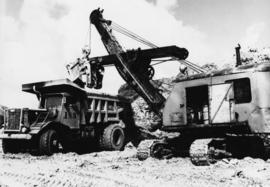
Identified objects include Euclid ore hauling trucks, Wabco ore haulage trucks, drill rigs, derailed train car, Clark forklift, dump trucks, twisted steel girder, and cat machine.
Locations identified include the townsite, mill building, pit mine, tramline, railroad, the powerhouse, the plantsite, and the underground mine.
The following is abbreviated description of the incidents documented in this file:
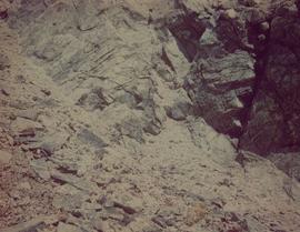
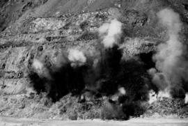
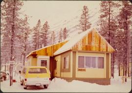
- Photos and negatives of a rock slide in the pit mine, a flooding creek, a house severely damaged by fire, a parking lot in Cassiar, and what are speculated to be oil drums.
- Various of Finning Tractor and equipment damage incidents, one occurred on 2 July 1981 because of HOS blade, another in Nov, 1987, and another in Oct. 1986. Also Euclid accidents, of which one occurred 29 May 1987
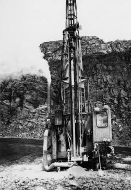
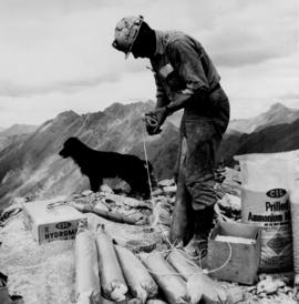
- Photos of split fibre bags in snow, a damaged brown car in Cassiar parking lot, various Blast Hole Drill accidents, of which one occurred in pit in September 1985, and another planned blast that failed to detonate - powergel 'A' slurry failure on 10 June 1985.
- a derailed train, and a young woman measuring damaged steel trellis.
- Photos of Drill #707 fallen over in bank, a broken haulage truck, a fire damaged truck, and of Drill and Wzbco accident, #650 Haulage Truck accident on Oct. 24, 1990, and another accident near gas pump area involving truck on 5 Feb. 1987.
- Photos of damaged tramline after avalanche with annotated envelope "Bill Zemenchick", a set of photos showing tramline trackrope incident in 1986, and a derailed tramline carts in discharge area on 6 October 1986.
- Photos of Pressure Packer Accumulator Failure from the Plantsite in 1986, incident neraby Fibre Storage building involving #872 Forklift during 80s, another incident involving the #489 Hydraulic Shovel in the Mine during 80s.
- Photos of broken windshield and overloaded bucket on 30 April 1985, a screw gun malfunction caused by outlet having 600v power source in 1985, incident caused injury.
- Photos of "G" conveyor accident in April 1988, equipment damage in Underground mine in 1990, damaged screens in Mill, malfunctioning blade incident 11 Jan. 1992.
- Photos of Cat Engine cracking, damaged garbage truck, Haulage Truck engine failure on 27 Oct. 1986, Truck #84 backed into trench on 17 Oct. 1990, a loader that caught fire 21 June 1989, a grader accident on 21 Nov. 1985, and Haul track #59 broken tie rod that caused significant equipment damage.
- Photos of a fuel oil spill on 11 June 1990 in the Cassiar valley around plantsite.
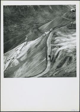
- Photos of ground failure in Cassiar open pit 22 June 1988, 5 May 1987, and 2 Sept. 1987.
- Photos of damaged tires and damaged cart, a panfeeder accident in trench, shovel accidents on 6 March 1986 and 15 November 1986, Cylinder rod accident on 7 March 1986, manhole incident 9 April 1984, snow damage to building 29 March 1982, another loader engine fire on 3 Sept. 1987, and a broken tail light on 6 April 1988.
- Photos of accident in Underground mine when drilling piece of shotcrete fell on 20 June 1991, incident of disconnecting sling from chute causing damage on 4 July 1990, and accident in open pit of machinery going off road on 14 January 1988.
- Photos of Mine Garage Parts-room fire collection; 18 January 1986, also included are two photographs of a Euclid truck - kept with collection of context. Truck could have been used to transport debris.
- Important collection of three photographs of scoop tram sabotage incident - "foul play" on 15 June 1990. The Scoop tram was used in the underground mine.
Some of the above accidents involved personnel and therefore access is restricted - See Archivist for accessibility.
File contains 20 slides date stamped between July and August 1976 and annotated “TRAILER SERVICE SUMMER 1976", depicting the construction and renovation of a mobile home, excavations, and structures believed to be wells or water boxes. File also contains 9 additional slides with no annotations, depicting mobile home and houses in winter. These 9 images are associated with materials dated Nov. – Dec. 1976 and it is likely that these photographs were taken in the winter of 1975-1976.
Photographs depict aerial views of the Cassiar townsite, plantsite, tailings pile, mine road, bench and pit mine, mine buildings (tramline loading station, crusher, shop, and garage), and surrounding mountain range. Here "aerial" refers to photos depicting a large area and taken from the air or from a high point of elevation.
Photograph depicts the Cassiar valley. Handwritten annotation on verso of photograph: "1958 [1961 crossed through]", on recto: "Cassiar Asbestos Corporation Limited. Cassiar B.C. Townsite in foreground mill and ore storage in left middle ground," "Toronto set". It is believed that this photograph was made into a post card.
Photograph depicts the Cassiar plantsite including the mill, dry rock storage building, tailings pile, and many other buildings. A portion of the townsite can be seen on left.