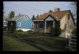
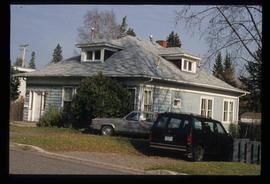
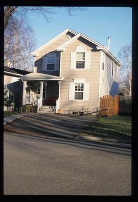
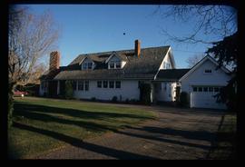
Image depicts 1690 Dogwood Street, on the corner of 17th Ave and Dogwood St. in Prince George, B.C. Also depicts a portion of 1670 Dogwood Street at left.
Image depicts 1650 Dogwood Street and 1670 Dogwood Street in the Millar Addition neighbourhood in Prince George, B.C.
Image depicts houses on Dogwood Street in the Millar Addition neighbourhood of Prince George, B.C. On the left is 1610 Dogwood Street and 1630 Dogwood Street is the middle house; 1650 Dogwood Street is the blue house on the right.
Image depicts 411 Patricia Boulevard in Prince George, B.C.
Image depicts a property given to the Veterans of the Second World War, located on the corner of 15th Avenue and Elm Street in Prince George, B.C.
Image depicts 1510 Fir Street in Prince George, B.C.
Image depicts 1566 Ingledew Street in Prince George, B.C.
Image depicts a view of the Millar Addition suburb from Connaught Hill in Prince George, B.C.
Image depicts 1480 Birch Street in Prince George, B.C.
Image depicts 1532 Fir Street in Prince George, B.C.
Image depicts 1590 Fir Street in Prince George, B.C.
Image depicts 1598 Fir Street in Prince George, B.C.
Image depicts 1488 Gorse Street in Prince George, B.C.
Image depicts 1386 Ingledew Street in Prince George, B.C.
Image depicts 1354 Ingledew Street in Prince George, B.C.
Image depicts 135 Patricia Boulevard in Prince George, B.C.
Image depicts Ash Street and Patricia Boulevard in Prince George, B.C.
Image depicts the Fraser River from Northwood Road in the Prince George area.
Image depicts a view of Tabor Mountain in Prince George, B.C.
Image depicts the Fraser River from the vantage point of the cutbanks in Prince George, B.C.
Image depicts a view of the Fraser-Nechako confluence from the Prince George cutbanks.
Image depicts a view of Prince George from the cutbanks.
Image depicts a view of Prince George from the cutbanks on the Nechako river.
Image depicts part of the McMillan Creek Trail in the McMillan Regional Park in Prince George, B.C.
Image depicts part of the McMillan Regional Park in Prince George, B.C.
Image depicts the McMillan Creek from Northwood Pulpmill Road, in Prince George, B.C.
Image depicts a farmhouse on Old Summit Road in Prince George, B.C.
Image depicts the Fraser River and the Grand Trunk Pacific Bridge from Cottonwood Island Park.
Image depicts Prince George at night from the cutbanks.
Image depicts a clearing in Prince George, B.C., possibly in the Pineview area.
Image depicts Prince George near the Airport Road.
Image depicts a clearing in Prince George, B.C.
Image depicts the Pearson Homestead.
Image depicts a view of Peden Hill in Prince George, B.C.
Image depicts Highway 97 at 15th Ave. looking north. Map coordinates 53°54'36.0"N 122°46'55.5"W
Image depicts Highway 97 at 15th Ave. looking north. Map coordinates 53°54'42.1"N 122°46'53.1"W
Image depicts the Canadian National Railway Yards in Prince George, B.C.
Image depicts a rural setting, most likely near the airport in Prince George, B.C.
Image depicts a few houses, most likely near the airport in Prince George, B.C.
Image depicts mobile homes for sale on Cowart Road looking northeast with Simon Fraser Bridge in background. Map coordinates 53°52'39.3"N 122°46'13.1"W
Image depicts Tabor Mountain from the airport in Prince George, B.C.
Image depicts Parkwood Place taken from Connaught Hill looking west with the hospital in the background. Map coordinates 53°54'39.9"N 122°45'02.5"W
Image depicts Prince George from the view of Peden Hill.
Image depicts a view of Prince George from Carney Hill.
Image depicts a nature trail along the Nechako River at Island Cache looking west with the cutbanks in the background. Map coordinates 53°55'36.2"N 122°45'11.8"W
Image depicts an agricultural field, most likely near Prince George, B.C.
Image depicts power lines east of the pulp mills in Prince George, B.C.