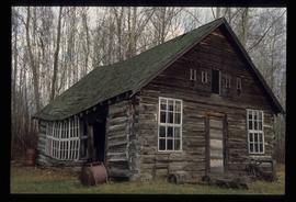
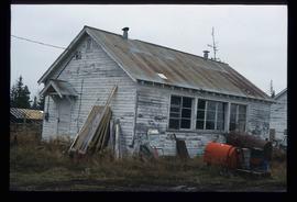
File contains slides depicting the Prince George region.
Image depicts a log cabin, possibly in Beaverly.
Image depicts the school site in Stoney Creek.
Image depicts a building in Red Rock.
Image depicts the Fraser River from Northwood Road in the Prince George area.
Image depicts a view of Prince George from the cutbanks.
Image depicts the Pearson Homestead.
Image depicts a rural setting, most likely near the airport in Prince George, B.C.
Image depicts a gauging tower at Shelley, B.C.
Image depicts a view of Prince George from Carney Hill.
Image depicts a nature trail along the Nechako River at Island Cache looking west with the cutbanks in the background. Map coordinates 53°55'36.2"N 122°45'11.8"W
Image depicts power lines east of the pulp mills in Prince George, B.C.
Image depicts the flows from a pulp mill in Prince George, B.C.
Image depicts an esker at the Foothills Boulevard in Prince George, B.C.
Image depicts an area undergoing logging somewhere in Prince George, B.C.
Image depicts a view of Prince George from City Hall looking northeast along George Street. Map coordinates 53°54'46.3"N 122°44'41.9"W
Image depicts a view of Prince George from City Hall looking north. Map coordinates 53°54'46.3"N 122°44'41.9"W
Image depicts a view of Prince George from Cranbrook Hill looking southeast. Map coordinates 53°54'51.5"N 122°49'05.2"W
Image depicts a view of Prince George from Cranbrook Hill looking east. Map coordinates 53°54'51.5"N 122°49'05.2"W
Image depicts a view of Prince George from Cranbrook Hill looking southeast. Map coordinates 53°54'51.5"N 122°49'05.2"W
Image depicts a view of Prince George from Cranbrook Hill looking east with pulpmill and downtown in background.
Image depicts Brunswick Street at 3rd Ave in -35 degree weather. Map coordinates 53°55'03.0"N 122°44'51.7"W
Image depicts the Central Business District of Prince George looking north from Connaught Hill. Map coordinates 53°54'41.4"N 122°44'58.5"W
Image depicts a view of Prince George from Gunn Point in the L.C. Gunn Park looking north. Map coordinates 53°54'26.2"N 122°43'35.8"W.
Image depicts the Fort George Park. Map coordinates 53°54'30.2"N 122°43'57.4"W
Image depicts a Bavarian style house at College Heights in Prince George, B.C.
Image depicts downtown Prince George looking northwest. Map coordinates 53°54'48.7"N 122°44'45.6"W
Image depicts a view of Prince George from City Hall looking northeast along George Street. Map coordinates 53°54'46.3"N 122°44'41.9"W
Image depicts the balcony of a log house, likely somewhere in or near Prince George B.C.
Image depicts the cutbanks on the other side of the Nechako, taken from the nature trail at Island Cache. Map coordinates 53°55'34.6"N 122°45'52.4"W
Image depicts a neighbourhood on the Hart Highway in Prince George, B.C.
Image depicts Parkside Intermediate Care Home on Ospika Boulevard in Prince George. Map coordinates 53°55'02.6"N 122°47'41.6"W
Image depicts 3rd Ave at Victoria St. Map coordinates 53°55'03.9"N 122°44'54.8"W
Image depicts George St in downtown Prince George with City Hall in the background. Also visible are the Prince George Hotel and a movie theatre. Map coordinates 53°54'55.0"N 122°44'36.1"W
Image depicts George St in downtown Prince George with City Hall in the background. Also visible are the Prince George Hotel, Ming's Inn Chinese Restaurant, Fraser Stationers Ltd., Weiner King food cart, and a movie theatre. Map coordinates 53°54'55.0"N 122°44'36.1"W
Image depicts Pine Centre Mall in Prince George, B. C. Map coordinates 53°53'53.2"N 122°46'36.4"W
Image depicts the Northwood pulpmill in Prince George B.C.
Image depicts the Yellowhead Bridge across the Fraser River. Map coordinates 53°54'45.2"N 122°43'27.9"W
Image depicts Mr. P.G. and the Tourism Information site at the intersection of Highway 16 and 97. Map coordinates 53°53'46.5"N 122°46'00.7"W
Image depicts a view over Tabor Mountain.
Image depicts a view of an experimental farm, possibly taken from Tabor Mountain.
Image depicts Prince George, possibly with the Northwood Pulpmill in the background.
Image depicts a sawmill, possibly Lakeland Sawmill, in Prince George B.C.
Image depicts a pulpmill, likely Northwood, in Prince George, B.C.
Image depicts Pineview on Buckhorn Lake Road, Prince George, B.C.
Image depicts the Northwood Bridge in Prince George, B.C.
Image depicts the Prince George Sawmill from the Northwood Bridge.
Image depicts Studio 2880 Arts Complex in Prince George, B.C. Map coordinates 53°54'36.9"N 122°46'30.3"W