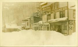
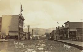
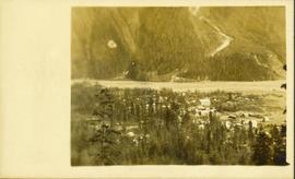
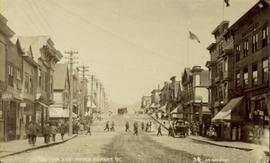
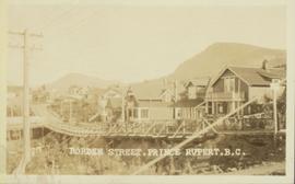
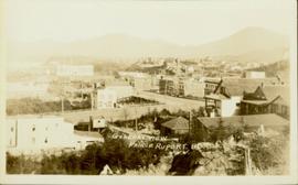
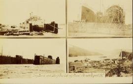
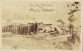
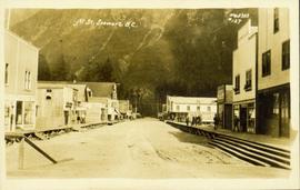
Street view photograph of 5th Street. Printed annotation on recto reads: "5th St. Stewart, B.C. Hughes #127."
Street view of various buildings in Stewart, BC, covered with a heavy layer of snow. Visible businesses include "The R. Boyd Young Co." and "Stewart Land Co." Printed annotation on recto reads: "Stewart B.C. Hughes 78."
Photograph is a printed postcard depicting scattered small buildings and a tent. Trees have been removed from the area around the buildings and many stumps remain.
Photograph depicts Archdeacon William Henry Collison to left of wife Marion, who stands bent over garden on right. Church steeple visible behind wood fence in background. Hills can be seen in distance.
Handwritten annotation on verso reads: "Grandad & Grannie in garden at Kincolith".
Warf construction visible in foreground. Background consists of a few built structures and several tents, location unidentified.
Photograph depicts the multi-level Prince Rupert hospital with trees and shrubbery in the foreground. Annotation on recto of photograph states: "Prince Rupert Hospital W.W.W. Photo"
Photograph depicts Hotel Fort George with people, cars and power pole in foreground. Handwritten annotation on verso reads: “Hotel Fort George - 1913”.
Street scene showing people, dog, team of horses & wagon. Signage reads: “Beds; Mecca Café; Hardware.” Printed annotation on recto reads: “Hamilton Avenue, South Fort George, B. C. No. 110.” Verso displays cancelled 1 cent Canadian Postage Stamp and handwritten message in ink is addressed to Mr. Eathan Villard Burt Mish, U.S.A.
Photograph of Prince George Hotel with several early model cars and a few people. Printed annotation on recto reads: “Hotel Prince George, Prince George, B. C.”
Overhead view of commercial buildings in downtown Prince George. Printed annotation on recto reads: "Prince George, B.C."
Photograph taken from the intersection of 3rd Avenue and an unidentified street. Visible businesses include "Ben Baird The Smart Shop" and "C.N.R. Cafe." Printed annotation on recto reads: "3rd Ave. PR. George, B.C."
Aerial view of Prince George and surrounding forested area. Printed annotation on recto reads: "Prince George, B.C."
Buildings in foreground, waterscape in midground, trees and snowcapped mountains in background. Printed annotation on recto reads: “Marine and Fisheries Digby Island Prince Rupert B.C. McRae Bros”
Lofty view of Prince Rupert BC. Water crosses midground, hills and opposite shore in background. Printed annotation on recto reads: “Prince Rupert BC McRae Bros”.
View from of a large ship in dry dock surrounded by water. Printed annotation on recto reads: “G.T.P. Dry dock Prince Rupert B.C. McRae.”
People, cars, and trucks visible on street, buildings in background. Handwritten annotation on verso reads: “P. Rupert Main Street British Columbia Canada, McRae Bros".
View of large houses on hill and city streets below. Printed annotation on recto reads: “Prince Rupert Residences on Cliff Which Runs Thru the Heart Of the City”.
Side perspective street view of Prince Rupert Post Office, as well as neighbouring buildings including the Prince Rupert Bazaar. Printed annotation on recto reads: "Post Office Prince Rupert B.C." Unidentifiable photographer's stamp is on lower right corner.
Photograph depicts winter landscape with track and logs in foreground. Bridge, trees and cleared land in background.
Photograph depicts two men standing in front of very small wood building with tarp-covered roof. Chair and paper documents can be seen in front of building, trees and rough cleared land in background.
Handwritten annotation on verso: “The first newspaper office, South Fort George 1910."
Photograph of Stewart BC taken from a distance. Trees in the foreground slightly obscure the village, and a large mountain is visible in the background. Printed annotation on recto reads: "Stewart B.C. Hughes 93."
Street view of downtown Stewart, BC. Photograph shows boards propped up over the swampy area of the future road. Wood debris litters the foreground.
Overhead photograph of a forested area, with Stewart, BC visible in the distance.
Photograph is a printed postcard depicting a team of horses harnessed to a buckboard; a group of people standing on a platform outside a building near Stewart B.C. There are mountains in the background.
Photograph is a printed postcard depicting a wagon track between buildings situated on either side. There are mountains in the back ground. Possibly Stewart, BC.
Photograph depicts Marion and William Henry Collison standing on left with shovel, Bertha Collison on right, and young Muriel and Katherine Collison in centre with shovel (eldest daughters of W.E. Collison). Wood buildings cross midground, trees and hills visible in background.
Handwritten annotation on verso reads: "Garden at Kincolith / Grandad, Grannie / Mimi, Katie / Mother".
Shoreline perspective of an unidentified coastal village situated on B.C.’s north coast. European style houses run parallel to a rocky shore. Seven men and one child stand within this frame and totem poles and a mortuary pole are also visible along the shoreline.
Seven young boys enjoying a game of tug-a-war alongside a wooden track. Track runs along a picket fence through a village. A small girl watches the fun from the sidelines and older woman carries a basket in the background. Handwritten annotation in pen on verso reads: “Native children at play”.
Street scene depicts people, boardwalks, tents, and store front. Printed annotation on recto reads: “Centre St. Prince Rupert: B.C., Allen Photos May 17. 09” Handwritten message on verso is addressed to “Dearest Darr”
Elevated view of Third Avenue in Prince Rupert. What appears to be a firetruck is travelling down the road. Printed annotation on recto reads: "3rd Ave W Prince Rupert BC."
Street view of Third Avenue in Prince Rupert. Many vehicles are parked along the wooden sidewalk. Printed annotation on recto reads: "Third Ave. Prince Rupert. B.C."
Street view of Third Avenue in Prince Rupert. A large crowd of people is gathering along the sidewalks. Printed annotation on recto reads: "Third Ave. Prince Rupert. B.C."
Street view of 5th St. in Prince Rupert BC. The dirt road is flanked by two partially demolished rock faces. Printed annotation on recto reads: "5th St Prince Rupert, B.C."
Elevated photograph of Prince Rupert taken from a hill. Residential and business buildings are visible. Background shows water and wooded hills. Printed annotation on recto reads: "Prince Rupert BC 22."
Overhead view of the dry dock in Prince Rupert, BC. Printed annotation on recto reads: "Prince Rupert Dry Dock."
Elevated photograph of Prince Rupert taken from a hill. Printed annotation on recto reads: "Prince Rupert BC W.W.W." Handwritten annotation on verso reads: "2402 Cork Street."
Ground level view of the Prince Rupert dry dock. Hills are visible in the background. Printed annotation on recto reads: "Three Million Dollar Dry Dock and Shipbuilding Plant, Prince Rupert, BC."
Street level view of the United Church in Prince Rupert BC. Printed annotation on recto reads: "Photo J.W. United Church Prince Rupert."
Slightly elevated view of a large crowd gathered in a park during the winter in Prince Rupert, BC. They appear to be observing some sort of ceremony or event that is out of frame.
Elevated street view of Fulton Street in Prince Rupert, BC. City Hall is in the left foreground. Hills and water are visible in the background. Printed annotation on recto reads: "Fulton St. Prince Rupert. B.C. W.W.W."
Photograph of a Canadian Grain elevator next to the railway in Prince Rupert, BC. Printed annotation on recto reads: "C.G. Elevator. Prince Rupert."
Photograph of a small vessel on the ocean with a dock and harbour buildings in the foreground. Tents and piles of lumber can be seen among the buildings. Annotation on recto reads: "The Wharf, Prince Rupert, BC. 1657."
Lofty view of downtown Prince Rupert, with water and mountains in the background. Printed annotation on recto reads: "Prince Rupert, B.C."
Photograph of Centre Street in Prince Rupert on Dominion Day. The Union Bank of Canada is located on the left side of the street, and a decorative arch can be seen in the background. Annotation on recto reads: "Centre Sr. Prince Rupert Dominion Day Celebrations 1909 Allen Photo July 09."
Large crowd gathered on the street in downtown Prince Rupert around a lavishly decorated arch which reads "Come One Let 'Em All Come Come All. Welcome to Prince Rupert." Annotation on recto reads: "Arch Prince Rupert, BC. Dominion Day Celebration 1909. Allen Photo."
Slightly elevated view of a street intersection on the edge of a slope in Prince Rupert. The "Canadian Bank of Commerce" is visible in the foreground. Printed annotation on recto reads: "Prince Rupert. British Columbia."
Wide angle view of Borden Street in Prince Rupert. Many residential buildings line the wooden road with railing. Printed annotation on recto reads: "Borden Street. Prince Rupert B.C."
Slightly elevated view of an intersection surrounded by residential and business buildings in Prince Rupert BC. Printed annotation on recto reads: "General View Prince Rupert. B.C. W.W.W."
Collection of four photographs of the Prince Rupert dry dock. Printed annotation on recto reads: "Dry Dock and Ship Building Plant, Prince Rupert BC."
Ground level view of the Prince Rupert dry dock during what appears to be construction. Printed annotation on recto reads: "The Dry Dock of Prince Rupert."