Showing 54241 results

Archival description
21791 results with digital objects Show results with digital objects
Former ferry crossing
2012.13.2.15.09.2 · Item · 2005
Part of J. Kent Sedgwick fonds

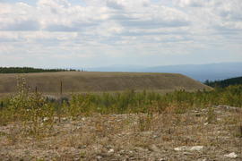
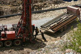
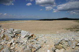
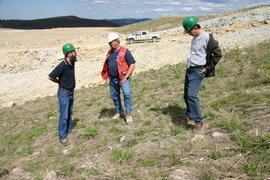
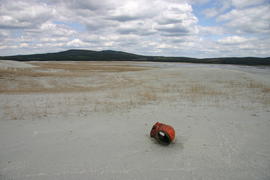
The item is a photograph depicting an the former Isle Pierre ferry crossing along the river. Annotation on the reverse side of the photograph states, "former ferry crossing 2005."

Former ferry crossing
2012.13.2.15.09.3 · Item · 2005
Part of J. Kent Sedgwick fonds

The item is a photograph depicting an the former Isle Pierre ferry crossing along the river. There is an abandoned wooden building next to the river.

Gauging station
2012.13.2.15.09.4 · Item · 2005
Part of J. Kent Sedgwick fonds

The item is a photograph depicting a gauging station at Isle Pierre. Annotation on reverse side of photograph states, "Isle Pierre gauging station WSC."

2012.13.2.15.19 · File · 2005-2006
Part of J. Kent Sedgwick fonds

File consists of notes, clippings, and reproductions relating to a failed tunnel build for the Grand Trunk Pacific Railway line between McBride and Goat River and a potential homestead on the land surrounding the tunnel. The land was later owned by Russ Purvis of Dunster in 2006.

Mark Gabriel Stadium
2012.13.2.06.13.1 · Item · 2005
Part of J. Kent Sedgwick fonds

The photograph depicts Mark Gabriel Stadium, a baseball stadium in Prince George. The photo was taken in 2005.

Building on Cariboo Highway
2012.13.2.06.16.01 · Item · 2005
Part of J. Kent Sedgwick fonds

The item is a photograph depicting a residential duplex house off the Cariboo Highway. It is one of three buildings that were relocated for the airport in 1957.

2012.13.2.11.16 · File · 2005
Part of J. Kent Sedgwick fonds

File consists of notes and reproductions relating to place-based computing geography methodology regarding inter-disciplinary research on experiences of place to teach history and geography and used by Kent Sedgwick.

Cameron Street bridge
2012.13.2.14.10.04 · Item · [between 2005 and 2008]
Part of J. Kent Sedgwick fonds

The item is a photograph depicting the Cameron Street bridge. The photograph is a reproduction of a photograph taken between 1917 and 1932. The picture depicts an ice jam with snow and ice along the Nechako River reaching the height of the base of the bridge. Annotations on the reverse of the photograph state, "Exp. Pl = 1922 p 986.9.9 Exp Pl = 16 Dec 1917 p 982 " 38.3 P 982.30.68 old bridge - can't be 1932."

Henry Wilson
2012.13.2.02.18 · File · 2005-2007
Part of J. Kent Sedgwick fonds

File consists of notes, clippings and reproductions relating to Henry Wilson, architect and former mayor of Prince George. Also includes a close-up photograph of Henry Wilson (1985) and photographs of the exterior of a house in Prince George.

2012.13.3.1.27 · File · 2005
Part of J. Kent Sedgwick fonds

File consists of notes and reproductions relating to the Ukrainian and Greek Orthodox churches in Prince George, includes material on St. George's Ukrainian Catholic Church at 2414 Vanier Drive in Prince George; St. Michael's Ukrainian Catholic Church at 2793 Range Road in Prince George; and Greek Orthodox Catholic Church at 1423 Seventh Avenue in Prince George. Includes: "St. Georges Ukrainian Catholic Church" postcard (2005) and "St. Georges Ukrainian Catholic Church" Christmas card (2005).

2012.13.3.1.41.1 · Item · 2005
Part of J. Kent Sedgwick fonds

The item is a photograph depicting a blue coloured house in the Millar Addition at 1570 Elm Street, Prince George. The house was previously used for veteran housing. Annotations on reverse side of picture state, "Millar Addition vet housing 1948."

2012.13.3.1.50.5 · Item · 2005
Part of J. Kent Sedgwick fonds

The item is a photograph depicting the front of the house located at 2540 Hazelton Street, Prince George. The house has white siding and has multiple units. Annotation on the reverse side of the photograph states, "2540 Hazelton."

2013.6.36.1.140.23 · Item · Oct. 2005
Part of David Davies Railway Collection

Photograph depicts the Esquimalt & Nanaimo Railway Alberni branch line, one mile east of the former Cameron Lake station. At this point, Highway 4 and rails "touch" each other for about 100 yards, but it was hardly noticable in those days because of bush growth.

2020.4.6.606 · File · 2005
Part of G. Gary Runka fonds

File consists of records created and accumulated by Gary Runka over the course of his consultancy work for Nature Trust of British Columbia for the "Presentation: Farms, Ranches and the Riparian Interface for Riparian Workshop" project in Oliver. This file was numbered as G.G. Runka Land Sense Ltd. client file #606; that client number may be seen referenced elsewhere in the G. Gary Runka fonds. The Land Sense Ltd. client files generally include records such as correspondence, contracts, invoices, project reports, publications, ephemera, memoranda, maps or map excerpts, legal documents, meeting materials, clippings, and handwritten notes.

2020.4.6.614 · File · 2005
Part of G. Gary Runka fonds

File consists of records created and accumulated by Gary Runka over the course of his consultancy work for Tlicho First Nation/Dogrib Treaty 11 Council for the "Participation in Land Use Planning Workshop" project in Rae, Northwest Territories. This file was numbered as G.G. Runka Land Sense Ltd. client file #614; that client number may be seen referenced elsewhere in the G. Gary Runka fonds. The Land Sense Ltd. client files generally include records such as correspondence, contracts, invoices, project reports, publications, ephemera, memoranda, maps or map excerpts, legal documents, meeting materials, clippings, and handwritten notes.