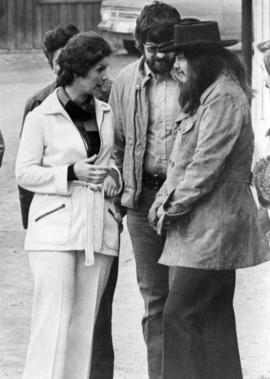
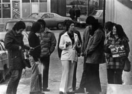
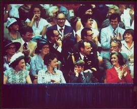
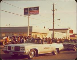
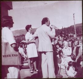
One man in crowd holds video camera. Margaret Trudeau stands in left foreground, looking on.
File consists of clippings and reproductions relating to Giscome. Includes various clipped articles from the Prince George Citizen newspaper (1974-1976).
Photograph depicts row of houses behind trees. Power line, road, and vehicles in foreground; mountain in background.
Snow can be seen on ground, and RCMP officer is visible in crowd. Unknown building in background.
Photograph depicts Skeena MP Iona Campagnolo speaking with George Brown of Burns Lake Community Development Corporation in Burns Lake while being filmed by director Paul Rockett. Unknown man in centre.
The pair appears to be shopping in unidentified location, crowd in background.
Photograph depicts Skeena MP Iona Campagnolo speaking with George Brown of Burns Lake Community Development Corporation in Burns Lake.
Image depicts the Giscome Community Hall in Giscome, B.C. Map coordinates 54°04'18.5"N 122°21'57.7"W
File consists of photocopies of photographs depicting Giscome, taken by Joy McKinnon.
Handwritten annotation on verso reads: “Fairview Opening, Prince Rupert, 1/3/75”.
Image depicts Highway 97 at 15th Ave. looking north. Map coordinates 53°54'36.0"N 122°46'55.5"W
Photograph depicts two unidentified men entering building with the sign "THE ROYAL BANK OF CANADA" above main entrance. Photographer with tripod in foreground.
Photograph depicts row of houses behind trees. Road, front yards, and vehicle in foreground, mountains in background.
Photograph depicts Skeena MP Iona Campagnolo speaking with George Brown of Burns Lake Community Development Corporation in Burns Lake while being filmed by director Paul Rockett.
Photograph depicts Skeena MP Iona Campagnolo speaking with George Brown of Burns Lake Community Development Corporation in Burns Lake while being filmed by director Paul Rockett. Unknown man in centre.
Image depicts Highway 97 at 15th Ave. looking north. Map coordinates 53°54'42.1"N 122°46'53.1"W
File consists of notes and reproductions relating to the closure of the Giscome mill. Also includes a photograph depicting the Giscome mill foundations after its demolition.
Sign in foreground reads: “Stop Bull Shitting, [Phoney (crossed out)] Ioney”.
Handwritten annotation on verso reads: “The Kitimat Oil Port Environmental Lobby, didn’t believe I killed it. I did!”
File consists of "The Prospect" newspaper, vol. 1 no. 38 described as 'The Last Edition'. "The Prospect" was a regional news-advertiser located in Prince George, and reached Quesnel, Vanderhoof, Mackenzie, Fort St. James, McBride, and other communities within a 100 mile radius.
Item is a hand drawn and coloured map by the City of Prince George Planning Department depicting zoning proposed by the Prince George City Planner for the VLA neighbourhood.
Iona Campagnolo smiles from back seat.
Photograph depicts Iona Campagnolo with John C. Lundquist and others in front of the Stewart Historical Museum. This photograph was taken with the intention of including it in Campagnolo's householder newsletter which was regularly sent to her constituents.
Image depicts an old, boarded-up store/office in Lamming Mills, B.C.
Subseries consists of material collected and created by Kent Sedgwick for research relating to museums and historical societies within Prince George. Includes material regarding the Fraser Fort-George Regional Museum, the Exploration Place Museum, the Prince George Railway and Forestry Museum, the Fraser-Nechako Historical Society, the Prince George Oral History Group, and the Prince George Genealogical Society. Also includes publications such as newspapers and calendars created by the museums and societies and various materials regarding activities conducted by the institutions.
File consists of letters and notes relating to the grave of Mr. Patterson of the overlanders near the original Fort in Prince George. Includes: "Regent's report" typescript document (3 Feb. 1976); "Letter to the mayor" typescript document to Mayor Backhouse from Maude D. Church (13 June 1991); and "Correspondence" printed emails between Mayor Backhouse and Maude D. Church (June 1991).
Item is a hand drawn and coloured map by the City of Prince George Planning Department depicting Hart Highway neighbourhood area existing land use in 1976.
Sin títuloItem is a hand drawn and coloured map by the City of Prince George Planning Department depicting the Blackburn neighbourhood development area's proposed sector plan in 1976.
Item is a hand drawn and coloured map by the City of Prince George Planning Department depicting the VLA neighbourhood proposed zoning in 1976.
Item is a hand drawn and coloured map by the City of Prince George Planning Department depicting public representations at the VLA neighbourhood zoning hearing that occurred on April 12, 1976.
Item is a hand drawn and coloured map by the City of Prince George Planning Department depicting zoning proposed by Prince George Alderman A. Stauble for the VLA neighbourhood.
Item is a map depicting the areas of spring and fall shadow in the Peden Hill neighbourhood in Prince George.
Item is Map 3 of a group of five maps relating to a City of Prince George Study of Construction Aggregates by the firm Willis, Cunliffe, Tair & Company Limited. Map 3 shows geology of the Prince George area and known sources of construction aggregates.
"The Asbestos Sheet" is a newspaper that documents the community and work life of the residents of Cassiar BC. Content includes text and photographs, as well as jokes, comics, and games.
Semi-visible sign reads: “Supertanks - Pipelines S.O.S.”
Publication contains "Memories of the Skeena", which accounts to life of Walter Wicks on the Skeena River in the years 1900-1922. Includes anecdotes and historical accounts of cannery work, railroad building, trapping, fishing, hunting, and the founding of Prince Rupert.
Photograph depicts Iona Campagnolo presenting a New Horizons program cheque to Queen Charlotte Islands senior citizens in Masset. The grant was made for the preparation of a written history of the Queen Charlotte Islands.
Photograph depicts Iona Campagnolo talking to an unknown male senior.
Image depicts the old, boarded-up community hall in Lamming Mills, B.C.
File consists of clippings, notes, and reproductions relating to the Fraser-Fort George Regional Museum in Prince George. Includes: "The Exploration Place" letter to Kent Sedgwick from Tracy Calogheros and the Exploration Place (19 Mar. 2008); "Annual Report" booklet from the Fraser-Fort George Museum Society (2008); and "Hunt starts for money, artifacts for museum" clipped article from the Prince George Citizen newspaper (15 June 1976).
Item is a hand drawn and coloured map by the City of Prince George Planning Department depicting the North Nechako and Hart neighbourhood area proposed land use in 1976.
Item is a hand drawn and coloured map by the City of Prince George Planning Department depicting existing land use for the Van Bow neighbourhood area.
Item is a map depicting a future medium density development plan for the Peden Hill neighbourhood in Prince George.
Item is Map 2 of a group of five maps relating to a City of Prince George Study of Construction Aggregates by the firm Willis, Cunliffe, Tair & Company Limited. Map 2 shows development areas and aggregate requirements for 1984 and 1994. As the map is undated, it is unclear whether the 1984 and 1994 dates are future estimates.
Item is Map 5 of a group of five maps relating to a City of Prince George Study of Construction Aggregates by the firm Willis, Cunliffe, Tair & Company Limited. Map 5 shows drill hole locations.
Photograph depicts crowd with individuals holding protest signs.
Forest and hills visible in distance.
Handwritten annotation on verso reads: “Autographs”.
Distance shot of car in front of a crowd of unidentified people.
Handwritten annotation on verso reads: “Matane P.Q., Summer / 77, with P.M. on Tour”.
File consists of clippings, notes, and reproductions relating to the Crescents neighbourhood of Prince George. Includes: "Heritage inventory Crescents" inside a duotang (1990); "For Vanc - Carney St. study" typescript document (1990); "RE: Rezoning" typescript letter to Mr. LaChance from the City of Prince George (23 Jan. 1980); and "School Board Administrative Building" typescript document (2 Feb. 1976).
Item is a hand drawn and coloured map by the City of Prince George Planning Department depicting North Nechako neighbourhood area existing land use in 1976.