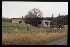
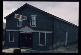
Image depicts the Giscome Community Hall in Giscome, B.C. Map coordinates 54°04'18.5"N 122°21'57.7"W
Image depicts the Giscome mill foreman's house on the hill. Map coordinates 54°04'28.0"N 122°22'05.8"W
Image depicts a dock at an inlet of Eaglet Lake in Giscome, B.C. There are numerous logs and other pieces of wood scattered in the foreground. Map coordinates 54°04'34.9"N 122°21'50.0"W
Image depicts the mill site at Giscome, B.C. Map coordinates 54°04'19.7"N 122°22'04.7"W
Image depicts a parking lot full of vehicles with the Giscome store in the background. Map coordinates 54°04'18.5"N 122°21'57.7"W
Image depicts the Giscome, B.C. mill site looking west. Map coordinates 54°04'18.5"N 122°21'57.7"W
Image depicts Kent Sedgwick sitting on the bank of a river. An old beehive burner is visible in the background. Located somewhere in or near Penny, B.C.
Image depicts the community hall in Penny, B.C.
Image depicts what is possibly the community of Newlands, B.C.
Image depicts a barn full of hay and several cows, possibly near Newlands, B.C.
Image depicts the CN Station, with bundles of wood sitting near the tracks, in Giscome, B.C. Map coordinates 54°04'32.3"N 122°21'42.3"W
Image depicts the dairy farm in Giscome, B.C. Map coordinates 54°03'53.3"N 122°21'22.6"W
Image depicts a Catholic church in Giscome, B.C. Map coordinates 54°04'15.5"N 122°21'52.1"W
Image depicts the Oblates of Mary Immaculate Catholic Church in Aleza Lake, B.C. Map coordinates 54°07'08.2"N 122°02'00.0"W
Image depicts a row of houses in Upper Fraser, B.C. Map coordinates 54°06'51.6"N 121°56'26.3"W
Image depicts a cookhouse at an uncertain location.
Image depicts the new Hansard Bridge. Map coordinates 54°04'57.9"N 121°51'10.1"W
Image depicts a street of shops at an uncertain location somewhere in the Peace River Regional District. A pink and blue building, possibly a theatre, is labelled "Lux."
Image depicts a cabin and several other buildings, possibly located in Hudson's Hope, B.C.
Image depicts a road and numerous buildings in Hudson's Hope, B.C.
Image depicts a street in Hudson's Hope, B.C.
Image depicts the W.A.C. Bennett Dam in Hudson's Hope, B.C.
Image depicts a view of Chetwynd, possibly from Highway 97.
Image depicts several unidentified individuals and a bridge behind them; it is possibly crossing the Peace River.
Image depicts a set of railway tracks and a long building located somewhere in the Peace River Region.
Image depicts a street of businesses in Dawson Creek, B.C.
Image depicts a street of businesses and Mile "0" of the Alaskan Highway in Dawson Creek, B.C.
Image depicts a Chevron station as well as two motels in Chetwynd, B.C.
Image depicts numerous pieces of what appears to be old farming equipment. There is also an unidentified individual sitting aginst the side of a building. The location is possibly Fort St. John, B.C.
Image depicts an unidentified man in a greenhouse, possibly somewhere in Fort St. John, B.C.
Image depicts a tunnel, possibly located somewhere in Fort St. John, B.C.
Image depicts what appears to be a computer room at an uncertain location, possibly in Fort St. John, B.C.
Image depicts a woman standing next to a model of a ship in glass case in what appears to be a museum. The location is uncertain.
Image depicts the Station Museum and the "Alberta Pool Elevators Ltd." building in Dawson Creek, B.C.
Image depicts stuffed wildlife exhibits inside the Station Museum in Dawson Creek, B.C.
Image depicts an old, collapsing cabin which is sloped sideways. The location is uncertain.
Image depicts Sue Sedgwick and a dog standing next to an old, collapsing cabin which is sloped sideways. The location is uncertain.
Image depicts a railway bridge, possibly in the small town of Fraser, located on the Klondike Highway in B.C.
Image depicts the train station in Carcross, Y.T.
Image depicts old machinery, at the Atlin Museum in Atlin, B.C.
Image depicts Atlin Lake as well as a small section of Atlin, B.C. The mountain is possibly Atlin Mountain.
Image depicts what appears to be a small community on the shore of a lake. The location is uncertain.
Image depicts Atlin Lake.
Image depicts the Globe Theatre in Atlin, B.C.
Image depicts numerous graves in the Atlin Cemetery.
Image depicts the Robert Lowe Bridge, built in 1922, in the Miles Canyon near Whitehorse Y.T.