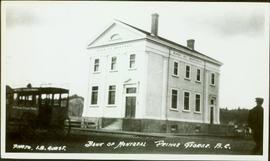
Showing 434 results

Archival description
2010.13.27 · Stuk · [ca. 1919]
Part of Prince George Historical Photograph Collection

Photograph depicts tall building standing alone on street. Stage coach in left foreground, unidentified man in right foreground.

Handwritten annotation on recto: "BANK OF MONTREAL PRINCE GEORGE. B.C. PHOTO. I.B. GUEST.", on verso: “Bank of Montreal, 3rd & Quebec, Prince George. Built in 1919".

2008.3.3.3.20 · Stuk · 26 May 1995
Part of Bridget Moran fonds

Photograph depicts Moran wearing regalia, embraced by her son Mike in Agora courtyard at the University of Northern British Columbia in Prince George, B.C. Unidentified individuals stand near Winter Garden in background. Accompanying note from Maureen Faulkner: "Mike Congratulations Mom!." Photo taken on the day Moran received an Honourary Law Degree.

2008.3.3.3.23 · Stuk · 26 May 1995
Part of Bridget Moran fonds

Photograph depicts Moran wearing regalia, facing away from camera in front of family members in the Agora courtyard at the University of Northern British Columbia in Prince George, B.C. Sons Mike (wearing black) and Pat stand on left, and Paul Ramsey stands in grey suit, semi-visible behind Moran. Unidentified individuals stand near Winter Garden in background. Photo taken on the day Moran received an Honourary Law Degree.

2011.12.03 · Stuk · ca. 1950
Part of Giscome, BC Historical Photograph collection

Photo depicts a street perspective cars lining Third Avenue, in Prince George, BC, ca. 1950. Annotation recto reads: "3rd Ave Prince George BC Photo J. Wrathall." Handwritten annotation in pen on verso of postcard reads: “This is the equivalent of our Granville Street. Both theatres are located here as well as Hudson Bay Co., banks, library & stores.”

Sawmill - Lakeland Mills?
2012.13.1.122.07 · Stuk · Oct. 1975
Part of J. Kent Sedgwick fonds

Image depicts a saw mill, possibly Lakeland Mills, with a beehive burner and numerous piles of logs in the foreground, in Prince George, B.C.

Suspended Trailer
2012.13.1.122.09 · Stuk · Oct. 1975
Part of J. Kent Sedgwick fonds

Image depicts a trailer for a logging truck suspended off the ground by a wooden structure. This is used to load the trailer onto the back of the truck. The name on the truck says "Rormarniewich Trucking Ltd."

Sawmill
2012.13.1.122.15 · Stuk · [1979?]
Part of J. Kent Sedgwick fonds

Image depicts logs being stripped of their bark at a saw mill in Prince George, B.C.

Skier in a Costume
2012.13.1.129.05 · Stuk · 1975
Part of J. Kent Sedgwick fonds

Image depicts a skier in a costume with a fake sword, somewhere on the Birchleg Ski route on Tabor Mountain in Prince George, B.C.

Handshake
2012.13.1.133.09 · Stuk · 1985
Part of J. Kent Sedgwick fonds

Image depicts a man and woman shaking hands in a building at an uncertain location, possibly in Cottonwood Park. The man standing behind the two is possibly Elmer Mercier, a former mayor of Prince George, B.C.

Fort George Regional Museum
2012.13.1.3.071 · Stuk · Oct. 1983
Part of J. Kent Sedgwick fonds

Image depicts the Fort George Regional Museum (now known as The Exploration Place) in Prince George, B.C. Map coordinates 53°54'18.6"N 122°44'09.8"W

Downtown Prince George
2012.13.1.3.082 · Stuk · May 1984
Part of J. Kent Sedgwick fonds

Image depicts downtown Prince George taken from City Hall looking north. Map coordinates 53°54'46.2"N 122°44'43.9"W

Salvation Army
2012.13.1.3.112 · Stuk · 12 Oct. 1989
Part of J. Kent Sedgwick fonds

Image depicts the Salvation Army on Ospika Boulevard in Prince George, B.C. Map coordinates 53°55'02.6"N 122°47'41.6"W.

Central Street West
2012.13.1.3.115 · Stuk · 12 Oct. 1989
Part of J. Kent Sedgwick fonds

Image depicts Central Street West, parallel to Highway 97 in Prince George, B.C. looking north. Shown: Prince George Motors and other car dealerships, Burger King, Grama's Inn, and the Spruceland Shopping Mall sign. Map coordinates 53°54'42.1"N 122°46'53.1"W

Foothills Bridge
2012.13.1.3.123 · Stuk · 12 Oct. 1989
Part of J. Kent Sedgwick fonds

Image depicts the Foothills Bridge over the Nechako river on the Foothills Boulevard in Prince George, B.C. Map coordinates 53°56'52.5"N 122°48'59.9"W

Prince George
2012.13.1.3.133 · Stuk · 12 Oct. 1989
Part of J. Kent Sedgwick fonds

Image depicts Prince George, possibly with the Northwood Pulpmill in the background.

Prince George Sign
2012.13.1.3.139 · Stuk · 6 Sept. 1993
Part of J. Kent Sedgwick fonds

Image depicts the Prince George welcome and population sign, with a population of 71,086. Map coordinates 53°53'52.0"N 122°46'08.7"W

Pineview
2012.13.1.3.145 · Stuk · [199-?]
Part of J. Kent Sedgwick fonds

Image depicts Pineview on Buckhorn Lake Road, Prince George, B.C.

Pineview
2012.13.1.3.146 · Stuk · [199-?]
Part of J. Kent Sedgwick fonds

Image depicts Pineview on Buckhorn Lake Road, Prince George, B.C.

2012.13.1.3.149 · Stuk · Apr. 1999
Part of J. Kent Sedgwick fonds

Image depicts a snow sculpted fire place and couch on a skating rink, possibly during the Winter City Conference, in Prince George, B.C. Taken at the Prince George Civic Center. Map coordinates 53°54'45.6"N 122°44'59.6"W

2012.13.1.3.150 · Stuk · Apr. 1999
Part of J. Kent Sedgwick fonds

Image depicts a snow sculpture of the Mr. P.G. lounging on a couch, possibly during the Winter City Conference, in Prince George, B.C. Taken at the Prince George Civic Center. Map coordinates 53°54'45.6"N 122°44'59.6"W

Northwood Pulpmill
2012.13.1.3.160 · Stuk · Nov. 2000
Part of J. Kent Sedgwick fonds

Image depicts the Northwood Pulpmill in Prince George, B.C. taken from above the Nechako River looking east. Map coordinates 53°56'00.0"N 122°44'29.7"W

City Hall
2012.13.1.3.165 · Stuk · May 2001
Part of J. Kent Sedgwick fonds

Image depicts Prince George City Hall. Map coordinates 53°54'46.3"N 122°44'41.9"W

2012.13.1.3.166 · Stuk · May 2001
Part of J. Kent Sedgwick fonds

Image depicts a view of Prince George from City Hall looking northeast along George Street. Includes a back view of the Prince George cenotaph. Map coordinates 53°54'46.3"N 122°44'41.9"W

Northern Rooms
2012.13.1.7.002 · Stuk · Oct. 1975
Part of J. Kent Sedgwick fonds

Image depicts an old building with a sign labelled "Northern Rooms" in an uncertain location somewhere in Prince George, B.C.