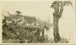
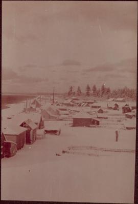
Gathering of tents in Vickersville with the harbour and mountains in the distance. Annotation on recto reads: "Vickersville Prince Rupert o/n[?] 1908."
Wide angled photograph of a sunset on the waterfront in Prince Rupert. Several buildings are silhouetted in the foreground. Annotation on recto: "Sunset, Prince Rupert, BC No. 4465."
Members of the Collison family casually fishing from a large dock. Handwritten annotation on verso reads: "Collison family fishing from dock (Portland[?] Canal) {Max Elsie Henry Will Arthur Herbert}."
Photograph of the Prince Rupert wharf. A small vessel is docked, and a large tree is in the foreground. Annotation on recto reads: "Prince Rupert Wharf & Harbor. Allen Photo."
Photograph of a stone monument atop a small hill on a forested shoreline. Annotation on recto reads: "Alexander Mackenzie Monument, Dean Channel, Near Ocean Falls, BC."
Photograph of a long bridge spanning two rock faces. A small settlement is visible on the lower right.
Overhead photograph of Giscome with the Eagle Lake Sawmill's beehive burner clearly visible in left foreground. Handwritten annotation in pen on verso reads: “Part of our community. school * ”
Side perspective of the teacherage located on Brown Ave. in Giscome. Photo taken in November after the first snow. Handwritten annotation in pen on verso reads: “Our House.”
Photo displays the height of the snow on the front porch of the Giscome teacherage after a blizzard.
Side perspective of Knox United Church in winter. Handwritten annotation in pen on verso reads: “The United Church.”
Photograph depicts village buildings along shore.
Handwritten annotation on verso reads: "Massett in Winter dress."
Handwritten annotation on verso reads: "Canyon on Nass River". Forest and mountains visible on shore in distance.
Photograph features a steep cliff across water, rocky shore in foreground.
Handwritten annotation on verso reads: "Up the 'Big Creek' at Kincolith B.C. Rock face called 'the place of echoes' by the Indian people."
Photograph depicts a bear at the garbage dump of the Gold River logging camp. Five other bears have retreated to the fire weed and blackened tree stumps.
Photograph depicts land clearance between Monashee Pass and Lumby, B.C.
Photograph depicts the view looking north from Diamond Head Lodge in Garibaldi Park, about 20 miles northeast of Squamish. Believed to be "Bookworm range" at 7910 ft.
Photograph depicts a baby seal at C.N. log drop at Cowichan Lake on Vancouver Island.
Image depicts the sky at either dusk or dawn, from an unknown location.
Image depicts a view of the Fraser-Nechako confluence from the Prince George cutbanks.
Image depicts a clearing in Prince George, B.C., possibly in the Pineview area.
Image depicts a clearing in Prince George, B.C.
Image depicts Tabor Mountain from the airport in Prince George, B.C.
Image depicts natural meadows, possibly east of Prince Georg, B.C.
Image depicts Fort George Canyon.
Image depicts a view of Prince George from Gunn Point in the L.C. Gunn Park looking north. Map coordinates 53°54'26.2"N 122°43'35.8"W.
Image depicts a view of Prince George, from Gunn Point in the L.C. Gunn Park.
Image depicts a couple walking through a nature trail in Cottonwood Island Park. Map coordinates 53°55'23.6"N 122°43'53.8"W
Image depicts an aerial view of Fort George Park.
Image depicts the cutbanks on the other side of the Nechako, taken from the nature trail at Island Cache. Map coordinates 53°55'34.6"N 122°45'52.4"W
Image depicts the Northwood pulpmill in Prince George B.C.
Image depicts a view of Blackburn Schools, possibly taken from Tabor Mountain.
Image depicts two snow sculptures near a wooden bridge on an ice rink, possibly during the Winter City Conference, in Prince George, B.C. Taken at the Prince George Civic Center. Map coordinates 53°54'45.6"N 122°44'59.6"W
Image depicts downtown Prince George taken from across the Nechako River looking south. Map coordinates 53°56'00.0"N 122°44'29.7"W
Image depicts a bear located at the Bear Lake Dump.
Image depicts Summit Lake.
Image depicts a canoe on the Fraser Lake.
Image depicts a view of the Crooked River Provincial Park.
Image depicts McLeod Lake.
Image depicts a road, forest, and hill rise in an uncertain location possibly near Red Rock, B.C.
Image depicts a river, possibly near Bear Lake, B.C.
Image depicts Prince George from University Way, with the P.G.I. Pulp Mill in the distance.
Image depicts Stuart Lake in Fort St. James, B.C.
Image depicts Blackwater River, B.C.
Image depicts the Cariboo Road at Hat Creek Ranch, near Highway 99 on the way to Lillooet.
Image depicts the Stanley Cemetery.
Image depicts McLeod Lake and several buildings along the shore.