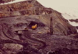
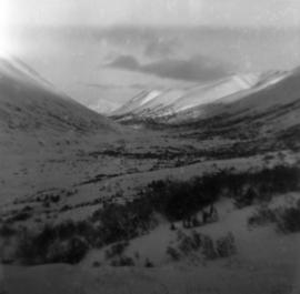
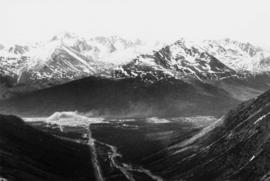
Photograph depicts mine valley and road in foreground. Cassiar plant visible in left midground, townsite in right midground. Southern mountain range in background.
Photograph depicts three women wearing matching attire in doorway of CP Air plane on runway. Small plane in foreground, field and trees in background. Handwritten annotation on verso of photograph: "Watson Lake June 14 71".
Photograph depicts yellow daffodils planted in dirt outside of main office building. Handwritten annotation on verso of photograph: "Cassiar June 15 71".
Photograph depicts two lawn chairs in front of building with front deck. Trees visible in foreground and background. Handwritten annotation on verso of photograph: "Directors Lodge Cassiar June 15 71". Building also known as "House 130".
Squirrel appears to be sitting on deck furniture of Director's Lodge at Cassiar, B.C. (see items 2000.1.1.3.19.88 and 2000.1.1.3.19.89).
Photograph depicts crusher plant in centre foreground. Shifter shack and vehicles can be seen in front of pit area. West Peak semi-visible in right midground. Mine valley an northwestern mountain range in background.
Photograph depicts plant buildings below, tailings pile in foreground. Valley and mountains in background. Handwritten annotation on recto of photograph: "CASSIAR".
Photograph depicts plant buildings in front of tailings pile in midground. Forest, power line, and tramline in foreground; south mountains in background.
Photograph depicts an unidentified man walking in front of orange and brown two-story building speculated to be bunkhouse residences. Second unknown individual can be seen unloading car in left foreground. Trees and mountains visible in background.
Photograph depicts two women and two men seated with food at dining table. Windows and curtains in background.
Photograph depicts unidentified man at orange lockers in the new Mine Dry change house. This building also housed a security office, and mine store where work apparel could be purchased (see item 2000.1.1.3.19.124).
Photograph depicts group of unidentified men seated in bus seats, wearing work clothes and hard hats. Believed to be taken on mine bus which ran between the plant and mine (see also item 2000.1.1.3.19.70).
Photograph depicts mine area. Switchback road and higher benches in background. Blasthole drills, track shovels, and ore haulage trucks can be seen on level in foreground and higher bench in background. Mountains visible in distance. Benches in background speculated to be located on the mine's West Peak.
Photograph depicts wheel bulldozer in snowy unknown area of mine.
Photograph depicts machinery in snowy area of mine. Euclid ore haulage truck in foreground, cassiar pickup truck visible in lower area in midground. Blasthole drill in front of track shovel in left background, Wabco ore haulage truck visible behind other machinery in right background.
Photograph depicts part of the vacuum dust control and removal system in the Cassiar mill building. Unidentified man can be seen at rotary air-lock, in which heavy blown dust would collect before dropping to plenum conveyor resting just above floor. From here, the dust would eventually be expelled at the tailings pile outside of the mill. Second unidentified man can be seen climbing steps in background. This section of the mill was located above the lab.
Photograph depicts Zora Ivanovska in safety gear, vaccuming asbestos dust from "hall screen" in mill (slanted vibrating tables with varying mesh sizes, used to separate different lengths of fibre). Mill General Foreman Tony Pinto is visible on far right, with unidentified man.
Photograph depicts three women wearing white aprons while conducting tests on asbestos fibre in lab area, miscellaneous equipment throughout room.
Photograph depicts the projected mining area of Asbestos Mountain, taken during the expedition of George Edzerza's party and their exploration of the future mine at Cassiar.
A collection of 10 photographs of documented exploration in the early 1950s in and around the Cassiar area. Noted locations are Quartz Creek, Mocassin Mines, Blue River Bridge and the Alaska Highway.
Photograph depicts a dirt road 6 miles from the Alaska Highway.
Photograph depicts three small camp structures in dirt landscape: one trailer, one wooden building and one tent building. Logs and wood pile in foreground, forest and snow-capped mountain in background.
Photograph depicts snow-covered Asbestos Valley, slightly north of asbestos deposit.
Photograph depicts five trucks and Eimco loader in snow-covered campsite. Photo taken facing south, forest and snow-covered mountains in background.
Photograph depicts McDame Creek road, snow-covered and taken from center of road, 1.5 miles from the early construction camp at Cassiar. Trees and mountains in background.
Photograph depicts snow-covered Asbestos Valley from a low altitude point on the mountain road leading to the mine.
Photograph depicts first bunkhouse with lumber piles and power pole in foreground, trees and mountains in background.
Photograph depicts tent structures in the early construction camp at Cassiar. Snow-covered area in foreground, trees in background.
Aerial photograph of Clinton Creek, south east of plant site.
Aerial photograph of Clinton Creek, north west of plant site.
Aerial photograph of Clinton Creek, south east of plant site.
Aerial photograph of Clinton Creek, north west of plant site.
Aerial photograph of Clinton Creek, west of plant site.
Aerial photograph of Clinton Creek, south west of plant site.
Aerial photograph of Clinton Creek, north west of plant site.
Aerial photograph of Clinton Creek, north of plant site.
Aerial photograph of Clinton Creek plant site.
Aerial photograph of Clinton Creek, south west of plant site.
Aerial photograph of Clinton Creek, south of plant site.
Aerial photograph of Clinton Creek, east of plant site.
Aerial photograph of Clinton Creek, south east of plant site.
Photograph depicts range of hills. Trees in valley, clouds in background.