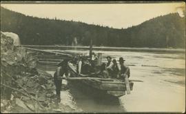
Photograph depicts one man seated in rear of canoe on still water. Trees on opposite shore in background. This man is believed to be a member of the Bourchier forestry crew.
Photograph depicts group of men seated on scow carrying unidentified material. One man stands on rocky shore in left foreground, leaning on plank attached to scow. A second scow can be seen behind men. Tree-covered hills on opposite shore in background.
Photograph depicts men walking among stumps and log piles in forest clearing of the railway right-of-way.
Photograph depicts man standing among six snow-covered buildings in what is believed to be a railway construction camp. Power line in foreground, forest trees in background.
Photograph depicts dog standing next to man smoking pipe and leaning against large snow bank (snow stands taller than man). Power lines connect to wood building standing in background. Photograph believed to have been taken in railway construction camp.
Photograph depicts railway crossing in front of tent buildings. Dirt road in foreground, forest trees in background. Photograph speculated to have been taken in a construction camp at Prince George.
Photograph depicts lane in front of tent buildings flooded with water, forest trees in background. Photograph taken from canoe, portion of canoe visible in foreground. It is believed that this photograph may depict the Island Cache in flood, at Prince George, BC.
Photograph depicts lane in front of tent buildings flooded with water. Tree in midground, forest trees in background. A man can be seen between first and second row of tent buildings. Photograph taken from canoe, portion of canoe visible in right foreground. It is believed that this photograph may depict the Island Cache in flood, at Prince George, BC.
Photograph depicts two unidentified men standing and sitting at campfire by large fallen trees. Forest and mountains in background. Handwritten annotation on negative: "[?] Taken Near Kopoka".
Image is one of 65 photos documenting a survey of the Canada-Alaska Boundary, Taku River area, May 23 to Oct. 15, 1906.
This particular photo is one of 8 found in original enclosure with the following handwritten annotation: "From main camp up Kopoka River. Scenes with persons in." See also items 2006.20.3.14 - 2006.20.3.21.
Photograph depicts unknown man standing in water while pulling loaded canoe by rope. Rocky shore in foreground, mountains in background. Handwritten annotation visible on negative: "[?] hauling canoe. Big [?], Kopoka".
Image is one of 65 photos documenting a survey of the Canada-Alaska Boundary, Taku River area, May 23 to Oct. 15, 1906.
This particular photo is one of 8 found in original enclosure with the following handwritten annotation: "From main camp up Kopoka River. Scenes with persons in." See also items 2006.20.3.14 - 2006.20.3.21.
Photograph depicts three unknown men standing in water while pulling loaded canoe by rope. Rocky shore and hills in background. Illegible handwritten annotation visible on negative: "...[K. River]?" (Kopoka?)
Image is one of 65 photos documenting a survey of the Canada-Alaska Boundary, Taku River area, May 23 to Oct. 15, 1906.
This particular photo is one of 8 found in original enclosure with the following handwritten annotation: "From main camp up Kopoka River. Scenes with persons in." See also items 2006.20.3.14 - 2006.20.3.20.
Photograph depicts man [Gilroy?] sitting with small tin cup. Canoe lies upside down in foreground. Water and opposite shore visible in background. Handwritten annotation visible on negative: "Camp. [Gilroy?] on way up from trail. 9 pm".
Image is one of 65 photos documenting a survey of the Canada-Alaska Boundary, Taku River area, May 23 to Oct. 15, 1906.
This particular photo is one of 13 found in original enclosure with the following handwritten annotation: "SOME OTHERS." See also items 2006.20.3.22 - 2006.20.3.34.
Photograph depicts two unidentified men standing to right of flag mounted in rock pile.
Image is one of 65 photos documenting a survey of the Canada-Alaska Boundary, Taku River area, May 23 to Oct. 15, 1906.
This particular photo is one of 13 found in original enclosure with the following handwritten annotation: "SOME OTHERS." See also items 2006.20.3.22 - 2006.20.3.34.
Photograph depicts unknown men standing with walking sticks, carrying large bundles on their backs. Water and opposite shore in background, mountains visible in distance. Handwritten annotation visible on negative: "Billy [Gilroy?] & [?] packed for [?]".
Image is one of 65 photos documenting a survey of the Canada-Alaska Boundary, Taku River area, May 23 to Oct. 15, 1906.
This particular photo is one of 13 found in original enclosure with the following handwritten annotation: "SOME OTHERS." See also items 2006.20.3.22 - 2006.20.3.34.
Photograph depicts group of six men standing and sitting in forest in front of tent structure with log base. Handwritten annotation visible on negative: "[Myself?] Main Camp".
Image is one of 65 photos documenting a survey of the Canada-Alaska Boundary, Taku River area, May 23 to Oct. 15, 1906. This particular photo is one of 9 found in original enclosure with the following handwritten annotation: "Pictures of different members of ‘our’ party.” See also items 2006.20.3.57 - 2006.20.3.65.
Group of five miners stand in mining area on left. Woman, man, and young girl sit and stand on far right in more formal attire. Mining tools and equipment throughout.
Printed annotation on recto of photograph: "Société Minière de B.C., Atlin B.C. July 28th, 1901, A.C. Hirschfeld, No. 707".
Several large buildings on a rocky shore. Wood piles and a crane are visible in the background. Annotation on recto reads: "Prince Rupert BC"
Photograph of a large waterfront factory. Annotation on recto reads: "Pacific Mills, Ocean Falls, BC. No. 2935."
Photograph of a large pile driver working on the waterfront at the foot of a forested slope. Printed annotation on recto reads: 'Pile-driver working on Government Wharf Hughes #55."
Side perspective photograph of a Portland Canal Short Line engine being either loaded or unloaded by several men at the station in Stewart, BC. Printed annotation on recto reads: "Aug 9 1911 Stewart BC."
Three men can be seen on deck of small boat. Rocky shore in foreground, forest and hills on opposite shore in background.
Handwritten annotations on verso read: "Dad - en route up Nass River on official business. (hence the flag & business suit!)"; "Going up the Nass. Dad (Indian Agent) Cap Barry (Inspect. of Schools) travelling up the Nass River to Aiyansh".
Photograph depicts pipeline construction for the Pacific Northern Gas pipeline from Summit Lake to Kitimat.
Photograph depicts a construction site for the Pacific Northern Gas pipeline from Summit Lake to Kitimat.
Photograph depicts Iona Campagnolo standing and examining a document with an unidentified union worker (possibly a member of the BC Ferry and Marine Workers Union) in either Prince Rupert or Kitimat. Two unidentified men are in the foreground.
Image depicts Upper Fraser residential area during demolition of town site. Map coordinates 54°06'51.6"N 121°56'26.3"W
Image depicts a loading truck at the Gibraltar mine site north of Williams Lake, B.C.
Handwritten annotation on recto of photograph: "FORMING FOOTING RETAINING WALL JULY 4/64." Photograph depicts construction workers
standing in forms for cement laid against mountain wall on high elevation of construction site. A retaining structure made with wood planks and rebar separates mountainside dirt from cement forms. A front end loader can be seen in midground, near unidentified building. Mountain range in background.
Photograph depicts shovel loading Kenworth haul truck in mine. Unknown man stands on left, mountain range in background.
Photograph depicts a man in work clothes and hard hat standing with hands placed on the first of many tram buckets hanging in a line. Steel beam framework of station building rises above him. Handwritten annotation on recto of photograph: "[F1?] LOADING STATION EL. 5800". Photograph was glued to cardboard backing with the annotation: "1962".
Photograph depicts red truck dumping waste at what is believed to be the tailings pile at the Cassiar plant. Small building and unidentified individual in bottom left foreground, valley and mountains in background. Photo caption next to printed copy of image in 1953 Annual Report: "Stockpile of 80,000 tons of Ore at Mill."
Photograph depicts a man wearing a hard hat preparing explosive material, mountains in background. Dog stands near edge in midground, large bags of Ammonium Nitrate in right foreground. Handwritten annotation on verso of photograph: "1961".
Photograph depicts a large shelter over building believed to be power house. Electricity lines cross midground and run to power house. A man can be seen crossing the foreground by steel frame supplies, and a second building is partially visible on right. Mountains stand in background and a crane can be seen operating in front of power house. Handwritten annotation on verso of photograph: "1961".
Photograph depicts unidentified woman using Bauer Mcnett machine to test length of fibre samples by using water. Woman stands facing wall, away from photographer, unidentified equipment on either side.
Photograph depicts unidentified man lifting package of asbestos bags with forklift in large building. Truck in background, ready for loading.
Photograph depicts two-story yellow and orange office building. Unidentified individual stands with garden hose in foreground near what appears to be a lawnmower. Warehouse semi-visible in left background; blue truck and new mill building visible in right background. Handwritten annotation on verso of photograph: "Cassiar Office June 15 71".
Photograph depicts two unidentified men in front of yellow and red helicopter at unknown location. Power lines and trees in background. It is possible that this photo may have been taken at Clinton Creek, Y.T. rather than Cassiar, B.C.
Photograph depicts woman wearing safety gear in second floor of mill building, holding unidentified instruments. Helen Joseph took air quality tests in the working areas and town (see item 2000.1.1.3.19.147).
Photograph depicts men building truck dump in foreground, building believed to be power house in background. Corresponding note on accompanying photo description page: "Pictures taken June 11th: (3) Framing water tank tower. Water well in foreground and tower timbers and oil tanks in background. Looking east." [Note believed to be incorrect.]
Corresponding note on accompanying photo description page: "1. Four staff members. L to R - Paisaud, Farewell, Hood, Ward - Taken in front of the office."
Photograph depicts 2 men working in building project area, trees in background. Corresponding note on accompanying photo description page: "1. Building concrete forms for diesel engine footings. Oil tanks in background."
Photograph depicts four men in business attire (two wearing ties) in doorway of log office building. Pile of snow in foreground on right. Corresponding note on accompanying photo description page: "6. In front of office; L. to R. Duncan, Hood, Ward, Jenkyns." It is believed that these men may be staff members.
Photograph depicts group of men working in dirt area, snow and trees in background. Corresponding note on accompanying photo description page: "10. Pouring concrete at mill. Steamer for heating water in foreground, concrete mixer in background." Concrete mixer is behind four steel drums.
Photograph depicts two unidentified men in coveralls and hard hats, working in garage. Blasthole drill stands behind them in midground, walls in background.
Photograph depicts two men wearing coveralls and hard hats in shop area. Wally Cameron stands on right.
Photograph depicts Chris Tates seated at table with paperwork in left foreground. David Pewsey stands behind on right, pointing to what appears to the Fibre Loading Schedule. Pewsey was supervisor of the Fibre Storage Shed. Both men wear hardhats. Tates believed to be wearing gold nugget Cassiar ring on left hand.
Item is a photograph of a CP Rail chip car being dumped. The development of the interior chip pulp industry necessitated new designs for chip rail cars and their dumping facilities.
Item is a photograph of the diversion tunnel as engineers plan to blast the plug to allow the Peace River to be diverted for construction of the W.A.C. Bennett Dam.
Item is a photograph of people and boats on a river’s edge.
Item is a photograph of a man pulling a furniture laden cart along a road.
Item is a photograph of a man making furniture.