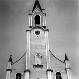
Photograph depicts a Roman Catholic church, "Our Lady of Lourdes," on the First Nations reservation, Sechelt Village. It was built in 1907 and is now closed, but the heavy bell is still in position in the belfry.
Photograph depicts a barn at Lund, a village 12 miles north of Powell River. This building overlooks the harbour.
Photograph depicts a house on Ladner Trunk Rd. in Delta, B.C. It is in the northeast corner of an intersection with the road leading to the Canadian Army Signal Station.
Photograph depicts the B.C. Forest Service Ranger's administration and equipment building at Pender Harbour in Sechelt, B.C.
Photograph depicts a settler's log cabin, about 1 mile from the main road of Sechelt Peninsula and on the side road leading to Gordon Bay, at a point where a small stream cease to be tidal. Vertical cracks in logs stuffed with rags and horizontal cracks filled with cement.
Photograph depicts a Chinese farmer's buildings on the Port Guichon Rd. on the outskirts of Ladner, B.C.
Photograph depicts a post office on Main St. in Cumberland on Vancouver Island. It was built in 1907 in a similar style to the building in Ladysmith.
Photograph depicts a Ukrainian Greek Orthodox Church on 27th St. and 41st Ave. in Vernon, B.C. in the Okanagan.
Photograph depicts the brick works at Haney, B.C., within 100 yards of the Fraser River. Current production appeared to be bricks, tiles, and flowerpots. There is a disused railway spur in the works
Photograph depicts the Kettle Valley Railway in Myra Canyon. The view is looking south at about mile 85.3.
Photograph depicts the CPR Kettle Valley Railway in Myra Canyon.
Photograph depicts the McCulloch CPR depot located at mile 76.7 on the Carmi Subdivision, which is about 27 miles northeast of Penticton. The rear building is the passenger depot, which was painted blue inside. The view is looking north.
Photograph depicts a gravel pit 1.5 miles north of the McCulloch depot or at approximately mile 78.0, on the Carmi Subdivision. It has not been in use since at least the late 1950s. The rails here are worn and dated 1910 and 1920s. The view is looking north.
Photograph depicts the trackage in the mid section of the McCulloch depot area. The left line is a passing track, the mid line is the mainline, and the right track is for storage. The depot is located at mile 76.6, on the Carmi Subdivision. The view is looking north.
Photograph depicts bridge #504 crossing Wilkinson Creek at the top end of the Sawyer loop. This is at about mile 50.75 on the CPR line in the Carmi Subdivision. The elevation here is 2973 ft. and the line is climbing at an even ascent. The view is looking northeast.
Photograph depicts the CPR line on the Carmi Subdivision at about mile 40.75 or 1.5 miles south of Beaverdell. The view is looking south and the photograph was taken from the top of a rock cut on the right.
Photograph depicts a booster telegraph relay station at Carmi. Carmi is located at mile 46.6 on the CPR line on the Carmi Subdivision. This is the only surviving telegraph pole between Penticton and Beaverdell. The view is looking east.
Photograph depicts the Carmi Depot located at mile 46.6 on the CPR line in the Carmi Subdivision. This is the only surviving building at the depot. The layout here consisted of 4 passing/storage tracks and 1 short siding. The view is looking north and upgrade.
Photograph depicts the CPR line at Boundary Falls, which is at mile 121 from Nelson on the Boundary Subdivision. The view is looking west and it shows the former flag stop shelter.
Photograph depicts the Fernie CPR station, located at mile 34.7 on the Cranbrook Subdivision, which runs from Crowsnest to Cranbrook. In coal mining days this was a busy place but now it has sidings for 153 cars and nothing else. The view is looking east.
Photograph depicts the CPR line at mile 126, on the outskirts of Midway. This is the end of the Boundary Subdivision and the line physically ends 3 miles west of here, at the Pope and Talbot lumber mill. The rail here is 100 lb., from 1926, and marked "O.I.E.S. Co. Ltd." The view is looking west.
Photograph depicts the CPR line near Midway, at the western end of the Boundary Subdivision. This points is 2.4 miles west of the Midway depot and denoted by a dump of ties laid on the rails. West of here was the Carmi Subdivision to Penticton (134 miles), which was lifted in two parts in 1979 and 1980.
Photograph depicts a 12 wheeler passenger car, CPR #411641, used as car man's sleeper. Behind it is wash/shower car #412718. It is followed by work diner car #411369, which is also a 12 wheeler with an arch bar truck. They are used for work and wreck train service.
Photograph depicts the Creston Sawmills Ltd on the CPR line. Here the southern BC CPR mainline passes through the center of trackage, looking eastbound. A chip car is on the spur directly leading from the camera.
Photograph depicts a westbound freight train near Moyie on the CPR line. This is at about mile 13 on the Nelson Subdivision, which spans 137.8 miles from Cranbrook to Nelson. The line here is adjacent to the Moyie Lake Provincial Campsite. The train is about to enter the portal of a small tunnel that bores through the rocky headland of the lake.
Photograph depicts water car #415319 standing on a little used spur in Nelson. It consists of a locomotive tender mounted on a flat car. It could be used as a firefighting unit, but it is merely lettered "service."
Photograph depicts a barge apron on Slocan Lake. Looking south along branch line which runs 31 miles to south Slocan junction.
Photograph depicts what is thought to be the Slocan branch line, near Passinae which is at mile 10.8 gtom south Slocan. This is at the point where the rail road and river lie close together. Approximately 20 miles west of Nelson.
Photograph depicts a branch that runs from Rosebury barge slip near Slocan Lake to Nakusp. A rare sight as a section of a man's house is still occupied, but whether or not by a railroader or not. This remains unknown. Trackage is used once a week by very small freight.
Photograph depicts the 27 mile branch line between Rosebury and Nakusp, looking north towards Nakusp. Officially, "Hills: is at mile 9.2 and was the sight of a former siding. However, since trunction in 1982 , it is now mile 5.3. Rails are consistently CPR 1902, weighing 80 Ibs. This information suggests that the track was relaid at this date (1902) and was never renewed.
Photograph depicts the branch line at old mile 24 between Rosebury and Nakusp or 22 1/2 rail miles south of Nakusp. Track used once per week or every other week. Shot freight passed this point 3 days afterwards. Rails are CPR, dated 1902, weighing 80 Ibs and are consistently laid as a batch.
Photograph depicts the existing south end of Rosebury to Nakusp branch. Line extends for 1/4 mile to booming ground/sawmill. Beach Lake was former building site of CPR steamers/scows. Rails are: Cammell 1901, Lorain 1902, Barrow 1903. All weigh 85 Ibs. The branch used to extend 3 1/2 miles to New Denver, but pulled up in 1982.
Photograph depicts the Kaslo Subdivision at the beginning of the branch which connects the Rosebury barge slip (on Slocan Lake) with Nakusp. Technically it is mile 3.9, but in 1983, it is actually about mile 0.2. The bridge is about 60 feet long. The inner gaurd rails are CPR, Kropp. Dated 1883. Weighing about 50 Ibs. Spans Wilson Creek.
Photograph depicts the upper yard of the barge connection with Slocan Lake. Nakusp is on mile 27 towards the north. The shack is the closest thing to a "depot" at this station.
Photograph depicts barge #6 after being loaded with 2 pole cars (CP 301595/945, built in 1954 and 1955) and refrigerators (CP 286 442) holding white pine destined for the USA. All "ex." mills at Nakusp. Time: 7:00 p.m. on a Thursday and it is raining. Stern of barge is the nearest to the camera. Tracks diverge to allow captains mounting at the center of the Stern.
Photograph depicts locomotive floating on barge slip and about to cross onto the barge. Followed by one loaded box car (white pine) and caboose. It is 7:00 p.m. and raining.
Photograph depicts part of the transfer barge #6 and tug ("Iris G") moved to rail pier with line to Nakusp (to right) in the foreground. It is used once a week or every other week.
Photograph depicts the lower end of the switch of the old line between Kaslo and New Denver. In the photo, we are looking toward the south.
Photograph depicts Lardeau's former depot - Gerrard Railway (CPR) and agents office at the CPR ferry ship in Lardeau. It was last used as such around 1966/67. In the weeds of the foreground, is a disused grain spur which connects to the trackage of the wharf. Rails on this spur are dated 1905.
Photograph depicts a barge loading a ramp. This is part of a tri-weekly service. Cars are loaded with dressed lumber, having been loaded at the fomer passenger wharf which has a conveniant platform for loading. The majority of the rails are dated 1908-1911/12, but a few are dated at around 1884 and 1885. This photograph looks toward the east.
Photograph depicts the east side of the upper harbour. Locomotive #6702 on Esquimalt & Nanaimo Railway street trackage crossing Chatham Street in south direction and entering premises of B. Wilson Co. Ltd Cold and Frozen Storage which has a spur that will take 2 (maybe 3) box cars. The empty box car (# 18705) is about to be removed.
Photograph depicts a daily passenger train north bound passing Goldstream Provincial Park between Goldstream and Niagara at about mile 12 or 13 (from Victoria). The train is reflecting a diesel fume cloud.
Photograph depicts the east side of the upper harbour in downturn Victoria. At some point a loaded box car was propelled into B. Wilson Company Limited Cold and Frozen Storage on Chatham Street. This could have been the start of the movement. Photo looks south on State Street.
Photograph depicts the arrival of the "Dayliner," car #9023. Photograph taken looking northward and at the rear of the train. About 25 passsengers got off at this location, possibly for the May Day parade.
Photograph depicts two CPR cars. One is numbered 436448. Location is not known for sure, but it could possibly be on the Esquimalt & Nanaimo Railway.
Photograph depicts a well cox spur, Flanger CPR #402819 is visible. Camera aimed southward.
Photograph depicts the Chemainus Depot, looking southward, at mile 51.2. There is evidence of repainting and repairs the depot and immediate surroundings.
Photo captures a northbound train that is just leaving the Ladysmith depot which is about 50 yards behind the camera at around 10:00 a.m.
Photograph taken at the Ladysmith depot on mile 58.4. A northbound train is just leaving at about 10:00 a.m.
Photograph taken at the Ladysmith depot on mile 58.4. Image captures a northbound daily train at about 10:00 a.m. Three people alighted and one has boarded.