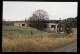
Print preview Close

Showing 4439 results

Archival description
3218 results with digital objects Show results with digital objects
Old House
2012.13.1.87.118 · Stuk · [between 1970 and 1990]
Part of J. Kent Sedgwick fonds

Image depicts an old house with a torn up roof. The location is uncertain.

Old House in Penny, B.C.
2012.13.1.87.119 · Stuk · [between 1970 and 1990]
Part of J. Kent Sedgwick fonds

Image depicts an old house in Penny and a woman, possibly Sue Sedgwick, standing in front of it. The location is uncertain.

River and Snow
2012.13.1.87.154 · Stuk · [between 1975 and 1995]
Part of J. Kent Sedgwick fonds

Image depicts what appears to be a small, narrow river, and mounds of snow. The location is uncertain.

Giscome Bunkhouse
2012.13.1.87.158 · Stuk · [between 1975 and 1995]
Part of J. Kent Sedgwick fonds

Image depicts the Giscome bunkhouse in Giscome, B.C. Map coordinates 54°04'17.6"N 122°22'06.1"W

Giscome Community Hall
2012.13.1.87.160 · Stuk · [between 1975 and 1995]
Part of J. Kent Sedgwick fonds

Image depicts the Giscome Community Hall in Giscome, B.C. Map coordinates 54°04'18.5"N 122°21'57.7"W

Giscome Dock and Wood Scraps
2012.13.1.87.166 · Stuk · [between 1975 and 1995]
Part of J. Kent Sedgwick fonds

Image depicts a dock at an inlet of Eaglet Lake in Giscome, B.C. There are numerous logs and other pieces of wood scattered in the foreground. Map coordinates 54°04'34.9"N 122°21'50.0"W

Giscome Sawmill
2012.13.1.87.168 · Stuk · [between 1975 and 1995]
Part of J. Kent Sedgwick fonds

Image depicts the mill site at Giscome, B.C. Map coordinates 54°04'19.7"N 122°22'04.7"W

Giscome Sawmill
2012.13.1.87.170 · Stuk · [between 1975 and 1995]
Part of J. Kent Sedgwick fonds

Image depicts the mill site at Giscome, B.C. Map coordinates 54°04'19.7"N 122°22'04.7"W

Giscome Parking Lot
2012.13.1.87.174 · Stuk · [between 1975 and 1995]
Part of J. Kent Sedgwick fonds

Image depicts a parking lot full of vehicles with the Giscome store in the background. Map coordinates 54°04'18.5"N 122°21'57.7"W

Giscome Sawmill
2012.13.1.87.176 · Stuk · [between 1975 and 1995]
Part of J. Kent Sedgwick fonds

Image depicts the Giscome, B.C. mill site looking west. Map coordinates 54°04'18.5"N 122°21'57.7"W

Kent Sedgwick
2012.13.1.88.35 · Stuk · 1980
Part of J. Kent Sedgwick fonds

Image depicts Kent Sedgwick sitting on the bank of a river. An old beehive burner is visible in the background. Located somewhere in or near Penny, B.C.

Newlands?
2012.13.1.89.028 · Stuk · Mar. 1975
Part of J. Kent Sedgwick fonds

Image depicts what is possibly the community of Newlands, B.C.

Chetwynd
2012.13.1.91.32 · Stuk · Nov. 1978
Part of J. Kent Sedgwick fonds

Image depicts a view of Chetwynd, possibly from Highway 97.

People and a Bridge
2012.13.1.91.50 · Stuk · 1979
Part of J. Kent Sedgwick fonds

Image depicts several unidentified individuals and a bridge behind them; it is possibly crossing the Peace River.

2012.13.1.93.29 · Stuk · 1978
Part of J. Kent Sedgwick fonds

Image depicts numerous pieces of what appears to be old farming equipment. There is also an unidentified individual sitting aginst the side of a building. The location is possibly Fort St. John, B.C.

Computer Room?
2012.13.1.93.52 · Stuk · 1978
Part of J. Kent Sedgwick fonds

Image depicts what appears to be a computer room at an uncertain location, possibly in Fort St. John, B.C.

Museum? - Ship Model
2012.13.1.93.57 · Stuk · Sep. 1984
Part of J. Kent Sedgwick fonds

Image depicts a woman standing next to a model of a ship in glass case in what appears to be a museum. The location is uncertain.

Railway Bridge
2012.13.1.98.03 · Stuk · 1999
Part of J. Kent Sedgwick fonds

Image depicts a railway bridge, possibly in the small town of Fraser, located on the Klondike Highway in B.C.