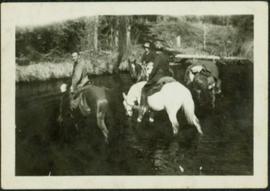
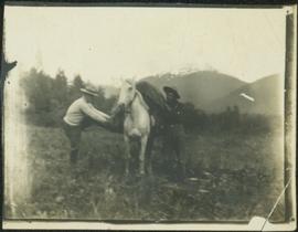
Photograph depicts two men believed to be North-West Mounted Police officers standing on either side of white packhorse. Forest and mountains in background. Photograph may have been taken in Vanderhoof, B.C.
Officers are mounted on three horses standing in water. Fifth horse stands on right, trees on shore in background. Handwritten annotation on recto of photograph: "Jas Tracey, Vanderhoof. Srg. Birch."
Photograph depicts Bill and canoe on sandy shore, river and opposite shore in background. Handwritten annotation on recto of photograph: "Billy Barnett at Giscome Portage."
Photograph depicts men on river boat and small canoe floating just off shore. Men sit and stand on shore among square bales and large cut lumber. Forest in background. Handwritten annotations on recto of photograph: "Fort Fraser wooding up at Giscome Portage", "Chilco at Giscome Portage".
Fred and Alan are being pushed in wheelbarrow by a woman wearing a blouse, dress pants, and sunglasses. Typed annotation on recto of photograph: "This is 'Mac' - she is a young woman." This woman is speculated to be Tom Taylor's wife Marion. They stand in a field with a car behind them. A forest and body of water can be see in background, as well as the opposite shore.
Mountains visible in background.
A woman stands in distance on a road with high snowbanks and trees on either side. A dog can be seen in foreground, facing woman. A fence and other structures stand in midground. Tree-covered slope in background.
Forest and mountain visible in background.
Handwritten annotation on slide casing reads: “behind hotel Costa do Sol”.
Photograph is one of seven images believed to have been taken on a Canadian University Service Overseas (CUSO) mission in Mozambique; see also items 2009.6.1.483 - 2009.6.1.489.
Photograph is one of seven images orginally included within a diary dated 12-22 November 1987. Photos depict a day to day account of Canadian University Service Overseas (CUSO) mission to establish whether or not a Canadian presence is justified in the fight against Apartheid and for the liberation of Namibia within a Soviet Sphere Socialist State. See also items 2009.6.1.490 - 2009.6.1.495.
Trees in foreground, hills in background. Unidentified man stands on far left.
Photograph is one of 11 images taken during a World Health Organization (WHO) trip, Human Rights of Women and Children, Peru, 1990. Possibly affiliated with World Council of Churches, International Ecumenical Delegation to Lima, Peru, 14-25 October 1990. See also items 2009.6.1.505 - 2009.6.1.515.
Handwritten notation affixed to verso reads: "Iona w/ Lee Morrison (late) director of First Nations Centre at that time. Soda Creek / net fishing for elders".
Photograph was taken during the chancellor's tour of Xats'ull Heritage Village, Soda Creek First Nation, Williams Lake, B.C.
Left to right: Deborah Poff, Dennis Macknak, Charles Jago, an unidentified woman, Iona Campagnolo, an unidentified man, Ellen Facey, and an unidentified woman. Unknown man stands on lower deck in foreground. Mountains visible in background. Photograph taken during the Chancellor's 1996 regional tour through Atlin and Whitehorse; see also items 2009.6.1.578 - 2009.6.1.581.
Handwritten annotation on verso reads: "#3 Chancellor's Tour".
Trees and town can be seen from balcony, and mountains are visible across water in background. Handwritten annotation on verso reads: “Aug 2006, Her Honor, Dorothy Grant & Carole Sabiston”.
Handwritten annotations on verso read: “Lawn Pool, Memorial, West Coast, VI, Summer ’06,” and “Sept. 15, 2006”.
An 'X' is marked in ink on forest in centre.
The Lieutenant Governor stands next to bridge and highway at top of image, cliffs and white water rapids visible below.
Handwritten notation affixed to verso reads: “Now Reflections in B.C.”
Photograph depicts a Kwakiutl petroglyph in Fort Rupert near Port Hardy. Handwritten annotations on verso reads: “Reversed negative, dry rock, 1957”; “Dry Rock, 1957”
Photograph depicts three young, First Nations girls standing in front of a memorial totem pole with houses and a forested environment visible in the background. Photographer’s stamp on verso: “W.E. Nicholson, 268 E. 10th, Vancouver 10, B.C.”
Photograph depicts a totem pole standing amidst a forested environment. Handwritten annotations on verso read: “Raven, ?, Sea Lions, Grizzly Bear, Dzondgwa”; “Kwakiutl Pole, Alert Bay & Fort Rupert” photographer’s stamp on verso: “W.E. Nicholson, 268 E. 10th, Vancouver 10, B.C.”
Photograph depicts a totem pole standing in front of a forested environment with a fence line in the foreground. Photographer’s stamp on verso: “W.E. Nicholson, 268 E. 10th, Vancouver 10, B.C.”
Photograph depicts a man in uniform and a woman posing for a photo on a road situated between a fenced area featuring totem poles. Along the water’s edge in the background there is a float plane, wharf and the Camosun vessel. Handwritten annotation on verso reads: “Alert Bay B.C. Union Steamships Ltd.”; “Alert Bay BC”; photographer’s stamp on verso states: “W.E. Nicholson, 268 E. 10th, Vancouver 10, B.C.”
Photograph depicts James Joseph Claxton standing in front of a fence with a memorial pole in the background. The memorial pole depicts painted First Nations designs, with additional totem poles and houses visible in background. Handwritten annotation in pen on verso reads: “Jim Claxton 1959”
A collection of postcard photographs of Port Essington BC, Port Simpson BC, Atlin, Quesnel, McBride, Hagwilget Village, Giscome, Likely, Kitwanga, Smithers, Prince Rupert BC, Prince (Fort) George BC Images depict street scenes, water scenes, community events, businesses, buildings, and aerials of the towns. Collection also depicts a number of Northern BC paddle wheelers.
View of building, dock, harbour and small islands with snow peaked mountains in background. Printed caption on verso reads: “Port Essington B.C. Photo by P. E. Fisher”. Handwritten annotation in ink on verso reads: “up the Skeena”, in pencil on verso: “Port Essington, North Coast Commercial Coy”.
Pier, house, and tress with snowcapped mountains in background. Image has been cropped to oval shape. Handwritten annotation in pencil on verso reads: “Port Simpson B. C. showing magnificent background in the distance”, on recto: "W. I. O'Neill Es. Aberdeen B.C. Hope you are well my dear D.D. - Have written to K. and are sending you and [?] Boy each a card. [?] will wish to saw we are all ok. Yours, M.", "Yours 10derly". Recto stamped "PORT SIMPSON B.C. MR 14 07".
Street view photograph looking down Carson Avenue at the Front St. intersection in Quesnel, BC. Several identified businesses line the gravel avenue on the right; however Cowan's Hardware store is visible at the intersection on the left. Printed annotation on recto reads: "Carson Ave., Quesnel, B.C. 1930 Looking East."
Photograph of the dirt road leading to Hagwilget Village. Residential buildings and a church are visible in the background. Printed annotation on recto reads: "W.W.W. Hagwilget Village."
Photograph of a vessel in a large body of water with several mountains visible in the background. Printed annotation on recto reads: "Atlin Mt., Atlin, B.C."
Photograph depicts pier under construction, workers, buildings smokestacks and river with chunks of ice. Handwritten annotation in pencil on recto reads: “S. FT. GEORGE G.T.P. BRIDGE”.
Lofty view of South Fort George, river and treed hills in the background. Printed annotation on verso reads: “South Fort George - 1913.” Handwritten message on recto is addressed to “Ethel M. Heurris Norton Maps Bristol County" reads: "11-1-13 an excellent view of south Fort George taken recently. Power Station at cross near water. This does not give all the south residence view. Population approx 1500”.
View of Cluster of buildings with treed hill in the background. Printed annotation on verso reads: “NEAR FORT GEORGE B.C.”
Photograph depicts buildings and vehicles lining street, and hill in background. There is snow on the road and several store signs are visible. Printed annotation on recto reads: “GEORGE ST. PRINCE GEORGE B.C.”
Printed annotation on recto reads: “George St. Prince George B.C.”, handwritten in pencil on verso reads: “CA. 1915”
Wide angle photograph of a sparsely forested area with Prince/Fort George in the background. Printed annotation on recto reads: "Fort George, B.C."
Street level photo of Third Avenue in Prince George. Visible businesses include "Cut Rate Grocery" and "C.N.R. Cafe." Printed annotation on recto reads: "3rd Ave. Prince George."
People, boardwalks, and store signs visible in street scene. Printed annotation on recto reads: “6th St. Prince Rupert. B.C.” Handwritten message in ink on verso is addressed to: “Mrs. Loistram Halls Buildings Nicholas St Limerick Ireland”. Verso stamped "PRINCE RUPERT JUN 30 10".
Lofty view of Prince Rupert BC. Water crosses midground, hills stand in background. Printed annotation on recto reads: “Prince Rupert BC McRae Bros”.
Boats, docks, ships and a large building in waterscape. Printed annotation on recto reads: “Prince Rupert B.C.” Handwritten annotation in pencil on verso reads: “McRae Bros”.
View of fish boat in water, with net spread and smaller boat on opposing side of net. Several gulls can be seen flying in the air. Rail cars town and treed hills in background. Printed annotation on recto reads: “Herring Fishing In Prince Rupert Harbour McRae Bros.” Handwritten message in ink on verso is addressed to “Mr. H. Smart 2550 Blackwood St. Victoria B.C.”
Two men standing beside wheelbarrows with signs that read: “Prince Rupert Transfer Co.” The men appear to be standing on large dock or boardwalk, water and hills in background. Printed annotation on recto reads: “Prince Rupert First Transfer Company.” Handwritten message in pencil on verso is addressed to “Mr. Gordon Penning 1600 Bld. Barclay Vancouver B.C.” Cancelation date on 1 cent Canadian Stamp is dated “Prince Rupert B.C. July 16, 09”.
Slightly elevated view of a street intersection on the edge of a slope in Prince Rupert. The "Canadian Bank of Commerce" is visible in the foreground. Printed annotation on recto reads: "Prince Rupert. British Columbia."
Wide angle view of Borden Street in Prince Rupert. Many residential buildings line the wooden road with railing. Printed annotation on recto reads: "Borden Street. Prince Rupert B.C."
Slightly elevated view of an intersection surrounded by residential and business buildings in Prince Rupert BC. Printed annotation on recto reads: "General View Prince Rupert. B.C. W.W.W."
Collection of four photographs of the Prince Rupert dry dock. Printed annotation on recto reads: "Dry Dock and Ship Building Plant, Prince Rupert BC."
Ground level view of the Prince Rupert dry dock during what appears to be construction. Printed annotation on recto reads: "The Dry Dock of Prince Rupert."
Ground level view of the Prince Rupert court house. Printed annotation on recto reads: "Court House." Handwritten annotation on recto in blue ballpoint pen reads: "Prince Rupert BC." Handwritten annotation on verso reads: "Hi Folks. Guess you've heard the good news by now. Well we've finished our cruises for this year so its home again finally to be with Marge and Janet. Will write shortly. Love Derek." Postcard is addressed to: "Mr & Mrs J.J. Oliver Box 666 Yarmouth N.S." Verso affixed with a three cent Canadian stamp. Postmark on verso reads: "Prince Rupert BC Oct 23 130 PM 1952."
Photograph of many fishing boats in a harbour. Printed annotation on recto reads: "Prince Rupert Halibut Fleet landing 500,000 LBS. WWW."
Water level photograph of several small vessels gathered around a large cold storage building. Printed annotation on recto reads: "Cold Storage, Prince Rupert B.C. 66."