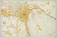
Showing 3619 results

Archival description
Fort George
2008.2.1.24 · Item · 3 January 1944
Part of Northern BC Cartographic Collection

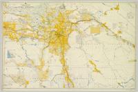
Colour-coded map depicting surveyed lands alienated, available for purchase or lease under Land Act, and available for pre-emption. Depicts land districts, land recording districts, provincial forests, parks, game reserves, communities, bodies of water, transport routes, communication lines, and triangulation stations.

Fort George
2008.2.1.27 · Item · 1 May 1949
Part of Northern BC Cartographic Collection

Colour-coded map depicts surveyed lands alienated, available for purchase or lease under Land Act, or available for pre-emption. Depicts land districts, land recording districts, provincial forests, parks, game reserves, communities, bodies of water, transport routes, communication lines, triangulation stations, and government reserves.

2008.27.4 · File · 1998-2003
Part of Knox McCusker Collection

File consists of the following materials:

  • Letter to Vernon C. Brink from the National Archives of Canada re: Knox McCusker holdings (March 1, 1999)
  • Photocopy of article: "Living Landscapes: Exploring the wilds of northeaster BC" by Ross Peck and Brian Apland
  • Some materials for an article on Knox McCusker, D.L.S.
  • Material about the life of Knox Freeman McCusker
  • Letter to Mrs. Rutherford (Oct. 5, 1999) re: access to interview of Knox McCusker by Frank Willis
  • Accession information print-out re: interview of Knox McCusker by Frank Willis in 1954
  • National Archives of Canada accession information print-out re: Dominion Land Surveyor Diaries, 1881-1930
  • Mary Henry / Knox McCusker "Team" (April 19, 1998)
  • Letter to Mrs. Rutherford from George Ungar re: background information on Knox McCusker
2009.5.1.16 · Item · 1928
Part of Taylor-Baxter Family Photograph Collection

Twenty-three year old Violet stands wearing a polka dot dress in a group of unidentified men, women and children. Body of water and tree-covered hill on opposite shore in background. Handwritten caption below this photo reads: "Pr. Rupert, 1928 End of Road Construction".

2009.5.1.75 · Item · 14 June 1911
Part of Taylor-Baxter Family Photograph Collection

Handwritten annotation on verso of photograph: "G.T.P. 1st Passenger Train From Prince Rupert. Mile 45. June. 14th 1911. Copyright. F. Button. PHOTO. Pr. Rupert. No. 240." Photograph depicts three men (two sitting on chairs) on caboose of train. Power poles run parallel to tracks, which curve to the right of the image. Train tracks in foreground, forest and mountain in background.

Bridge Near Burns Lake, BC
2009.5.1.90 · Item · [ca. 1915]
Part of Taylor-Baxter Family Photograph Collection

Photograph depicts a log bridge interrupting a wide dirt road in forest. Distant hills in background. Image has been cropped to an oval shape. Handwritten annotation on verso of photograph: "Fort George - Hazleton Highway Near Burn's Lake".

Unknown Men at Mine Adit
2009.5.2.39 · Item · 1939
Part of Taylor-Baxter Family Photograph Collection

Photograph depicts four men wearing suits and ties, standing in front of mine adit in rocky area, bushes in background. Handwritten annotation on recto of photograph: "1939 H.F. (Bert) Glassey with black hit in middle" (information regarding Glassey believed to be incorrect).

Men on Conveyor Deck
2009.5.3.55 · Item · [ca. 1912]
Part of Taylor-Baxter Family Photograph Collection

Photograph depicts men standing on different deck levels of conveyor in river. Wood planks built into shore in foreground, trees on opposite shore in background. It is speculated that this photo may have been taken near Tete Jaune Cache shortly after the conveyor was rebuilt. Handwritten annotation on verso of photograph reads: "Str. Conveyor".

2009.5.3.75 · Item · 1912
Part of Taylor-Baxter Family Photograph Collection

Photograph depicts creek barely visible at bottom of steep valley in cliffs. Trees and underbrush in foreground. It is believed that this photograph may have been taken near Mt. Robson. Handwritten annotation on recto of photograph reads: "Sand Creek."

2009.5.3.89 · Item · [ca. 1917]
Part of Taylor-Baxter Family Photograph Collection

Photograph depicts bridge over Nechako River. Sloped cutbanks on opposite shore in background. Railroad tracks can be seen on town shore in right foreground. Handwritten annotation on verso of photograph: "NECHAKO RIVER NEAR PRINCE GEORGE B.C. N.H.D."

2009.5.3.108 · Item · 1911
Part of Taylor-Baxter Family Photograph Collection

Photograph depicts men on river scow, large rock island or peninsula protruding into river behind them. Trees on opposite shore in background, large rock in foreground. Handwritten annotation on verso of photograph: "Grand Canyon. Fraser River. Big Rock.", on recto of copy print: "1911."

2009.5.3.152 · Item · [ca. 1910]
Part of Taylor-Baxter Family Photograph Collection

Photograph depicts boats on river and shore. Riverbank in foreground, buildings and forest on opposite shore in background. Mountains can be seen in distance. Illegible handwritten annotation on verso of photograph. Poor image quality, left portion of image is not visible.

Loading for the Peace River
2009.5.3.158 · Item · [ca. 1910]
Part of Taylor-Baxter Family Photograph Collection

Photograph depicts six men by building on shore. One man sits in small boat that has been loaded onto a wagon. River and opposite shore in background. Handwritten annotation on verso of photograph: "Loading for the Peace River." Photograph believed to have been taken either at Giscome Portage, or the trading post at Summit Lake, BC.