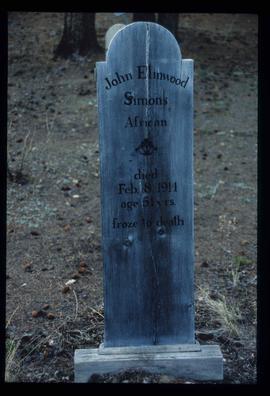
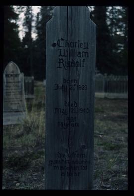
Imprimir vista previa Cerrar

Mostrando 2133 resultados

Archival description
1985 resultados con objetos digitales Muestra los resultados con objetos digitales
Atlin Lake?
2012.13.1.98.46 · Item · 1999
Parte de J. Kent Sedgwick fonds

Image depicts what is possibly Atlin Lake, with numerous mountains in the distance and Atlin Mountain visible on the right of the image.

Atlin Road?
2012.13.1.98.43 · Item · 1999
Parte de J. Kent Sedgwick fonds

Image depicts what is possibly Atlin Road. Numerous mountains are visible in the distance.

Atlin - the Tarahne
2012.13.1.98.32 · Item · 1999
Parte de J. Kent Sedgwick fonds

Image depicts a boat named "the Tarahne," which is located in Atlin, B.C. Atlin Lake and Mountain are visible in the background.

Atlin - A Dock
2012.13.1.98.31 · Item · 1999
Parte de J. Kent Sedgwick fonds

Image depicts a dock on the shore of Atlin Lake, as well as a building that may have once been a hospital. The slide is simply labelled "hospital."

Atlin - the Tarahne
2012.13.1.98.29 · Item · 1999
Parte de J. Kent Sedgwick fonds

Image depicts a boat named "the Tarahne," which is located in Atlin, B.C. Atlin Lake and Mountain are visible in the background.

Footbridge?
2012.13.1.98.28 · Item · 1999
Parte de J. Kent Sedgwick fonds

Image depicts what appears to be a footbridge at an uncertain location.

Atlin Lake
2012.13.1.98.14 · Item · 1999
Parte de J. Kent Sedgwick fonds

Image depicts Atlin Lake as well as a small section of Atlin, B.C. The mountain is possibly Atlin Mountain.

Fraser, B.C.
2012.13.1.98.02 · Item · 1999
Parte de J. Kent Sedgwick fonds

Image depicts the small town of Fraser, B.C. Located on the Klondike Highway.

Road to Skagway
2012.13.1.98.01 · Item · 1999
Parte de J. Kent Sedgwick fonds

Image depicts the road to Skagway, Alaska. Possibly located on the Klondike Highway in British Columbia with Tutshi Lake on the left.

Kootenay Plains
2012.13.1.096 · Sub-séries · [between 1987 and 2004]
Parte de J. Kent Sedgwick fonds

File contains slides depicting the Kootenay Plains and surrounding areas in Alberta.

View of Pine Pass
2012.13.1.93.55 · Item · 1978
Parte de J. Kent Sedgwick fonds

Image depicts a view of Pine Pass on the border between Alberta and British Columbia in the Rocky Mountains.

Peace River
2012.13.1.93.36 · Item · 1978
Parte de J. Kent Sedgwick fonds

Image depicts the Peace River, possibly somewhere near Fort St. John, B.C.

Bare Trees
2012.13.1.93.35 · Item · 1978
Parte de J. Kent Sedgwick fonds

Image depicts a forest of bare trees, possibly somewhere near Fort St. John, B.C.

Group and a Bus
2012.13.1.93.34 · Item · 1978
Parte de J. Kent Sedgwick fonds

Image depicts a group of individuals and a bus with words that read: "Prince George Limousine & Charter." The river in the background is possibly the Peace River, and the location is possibly somewhere near Fort St. John, B.C.

Peace River
2012.13.1.93.27 · Item · 1978
Parte de J. Kent Sedgwick fonds

Image depicts the Peace River and visible layers of sediment deposits in the surrounding cliffs.

Examining Rocks
2012.13.1.93.21 · Item · 1978
Parte de J. Kent Sedgwick fonds

Image depicts three unidentified individuals examining rocks near a set of railway tracks at an uncertain location in the Peace River Region.