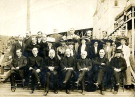
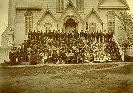
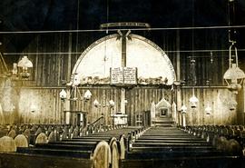
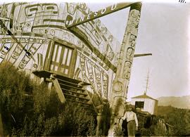
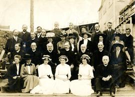
Group of men and women pose by large building. W.H. Collison sits second from left in second row, W.E. Collison stands third from right in back.
Handwritten annotation on verso reads: "Early synod of the Anglican Church at Prince Rupert B.C."
Group of men and women pose by large building. W.H. Collison sits second from left in second row, W.E. Collison stands third from right in back.
Handwritten annotation on verso reads: "Early synod of the Anglican Church at Prince Rupert B.C."
Group of men and women pose by large building. W.H. Collison sits second from left in front, W.E. Collison stands third from right in back.
Handwritten annotation on verso reads: "Anglican Church Synod / Prince Rupert".
Group of men, women, and children pose in front of large building.
Handwritten annotation on verso reads: "Metlakatla BC / with Bishop Ridley - 4th from left - back row / Mrs Ridley - 4th from left - front row / [?] - [super?] of Ridley Home (beside the Bishop) / Father Hogan - behind the Bishop".
Group of men, women, and children pose in front of large building. Rev. William Edwin Collison stands on far left (son of Archdeacon W.H. Collison).
Handwritten annotation on verso reads: "Early Church Workers at Metlakatla BC / Bishop & Mrs Ridley in centre / (Approx 1898 - 1899)".
Large church stands behind white fence, unidentified man visible on front steps. Photograph depicts the first church built in Metlakatla, which was burned in a fire in 1901, and replaced in 1903.
Handwritten annotation on verso reads: "With love, from your two old friends JH [& AM Keen?]".
Large group of women, men, and children pose on front steps of church. Some men standing in back hold brass instruments. Bishop Ridley (with long beard) sits in front centre between W.H. Collison (on right) and his son W.E. Collison. Photograph depicts the first church built in Metlakatla, which was burned in a fire in 1901, and replaced in 1903.
Handwritten annotation below image reads: "A gathering of Missionaries and Indians in front of Metlakahtla Church During Synod"; on verso: "[Ven?] Arch Collison & Mrs Collison".
Unknown buildings can be seen in background.
Banner at front of sanctuary reads "Do this in remembrance of Me".
Handwritten annotation on verso reads: "Interior of old church. Built by natives themselves".
Church stands behind white fence, road and power lines in foreground.
Handwritten annotation on verso reads: "St. Andrew's Church, Sandwick, [?] Campbell River Rd (Maud Highway) The mother church in the '[?] District'."
Many rows of pews span foreground. Banners hanging in front of sanctuary read: "THE ANGEL SAID UNTO THEM, FEAR NOT, BEHOLD I BRING YOU GOOD TIDINGS OF GREAT JOY WHICH SHALL BE TO ALL PEOPLE".
Handwritten annotation on verso reads: "Port [?] Church Interior."
River crosses midground, hills on distant shores can be seen in background.
Handwritten annotation on verso reads: "No. 32, First Beginning Prince Rupert, showing Church Hall, with cross. Insert Page 136".
Groups of men and women can be seen gathered on paths between two large totem poles.
Handwritten annotation on verso reads: "Totem Park Pr Rupert park."
Photograph depicts a large totem pole next to groomed dirt paths. Power poles and river visible in background.
Handwritten annotation on verso reads: "Edenshaw pole in park at Prince Rupert."
Photograph depicts a totem pole standing on what appears to be a large wooden deck or boardwalk, view of the city in background.
Handwritten annotation on verso reads: "Totem pole in park in Prince Rupert".
Photograph depicts a large ship behind dock buildings. Railroad crosses foreground, hills visible on shore in background.
Handwritten annotation on verso reads: "Ship in Pr. Rupert dry dock during Great War 1915?".
Aerial view of Prince George and surrounding forested area. Printed annotation on recto reads: "Prince George, B.C."
Three men stand in centre, each wearing a chief's dress and head-dress. Family members stand and sit on either side. Carved boxes and masks are positioned in foreground. The group poses in front of drapery hung against tall wooden wall.
Community members have stated that the people in this photo are from the Gitwilluyaxw clan from the wolf tribal house of Ksdiyaawak. The photo was taken at Gitlax̱t’aamiks along the Nass River.
Handwritten annotation on verso reads: "Tsimpshian Chiefs & family. Goods [for or fr.] Potlatch".
Photograph depicts two men standing at base of totem pole in front of large elaborate lodge building with post reading "MINESQU". Smaller structure stands in background (elevated cache?).
Handwritten annotation on verso reads: "Chapter XXIV. No. 3. A chief's lodge and totem Nass River."
Item is a photograph of Ray and Gladys Williston in front of their home in Princeton.
Item is a photograph of Ray Williston in Fredericton, NB.
Item is a photograph of Mr. Williston in Fredericton in February 1974.
Turkeys in foreground, shed in background.
Photograph depicts the Atlin townsite, forest in foreground, hills in background. Town stands on edge of lake located in left midground. Handwritten annotation on verso of photograph: "Atlin City B.C., Sept. 3rd 1899. Copyrighted by S.A. Smythe Atlin, B.C."
Handwritten annotation on verso of photograph reads: "W.E. Collison Masset. Interior of Chief [Weah's?] house".
Caption under printed version of photo in W.H. Collison's book 'In the Wake of the War Canoe': "The house is about 40 feet square, forming one large room. The upper cubicles are on a level with the ground, which in front of them is excavated so that the fireplace in the centre is twelve feet below the surface. A ledge, for the use of slaves and dependents, is left half-way down."
Two women stand in walkway cleared of snow in front of tall brick home with a detailed porch, believed to be in Victoria, B.C. The women wear long winter coats, fur hand-warmers, and large hats. It is believed that one or both of these women is a cousin to Violet Baxter's family, through the Taylor line.
Photograph depicts a former C.N.R. station at Youbou on Lake Cowichan on Vancouver Island. The track is still used to serve the plywood lumber mill at Youbou.
Includes an audiocassette and a CD copy of an interview conducted by Kent Sedgwick with Trelle Morrow on the history of architectural design in Prince George.
Morrow, TrelleThe Prince George Railway & Forestry Museum Society Collection consists primarily of textual, photographic, and cartographic records related to the regional developments of the railway industry in Northern BC. A predominant portion of the collection is made up of material from the Canadian National Railway; other railways represented include the Pacific Great Eastern Railway, the British Columbia Railway (BC Rail), the Grand Trunk Pacific Railway, the Grand Trunk Railway, the Intercolonial Railway, and the Okanagan Express. Significant geographical areas covered include Prince George, the Peace River Region, Terrace, Bulkley Valley, Hazelton and Prince Rupert.
The forestry industry is represented in the collection with operational and financial records from Fyfe Lake Sawmill Ltd., which operated southwest of Prince George in the 1950s.
The collection has been organized into series according to creator, each of which also has been arranged to subseries, file and item level, where applicable. This collection consists of eight series, as follows:
1) Canadian National Railway
2) Grand Trunk Railway
3) Pacific Great Eastern Railway
4) British Columbia Railway (BC Rail)
5) Canadian Pacific Railway (CPR)
6) Intercolonial Railway
7) Fyfe Lake Sawmill ltd.
8) PGRFM
9) Photographs
Photograph depicts a typical section shed scene anywhere in B.C. It was taken on the C.P.R. track near Flat Creek or Illecillewaet, between Rogers Pass and Revelstoke. The April 25, 1965 CPR Employee timetable lists the mileage at Illecillewaet as 98.2.
Photograph depicts the CPR depot at Proctor, located at mile 117.5 from Cranbrook on the Nelson Subdivision. David Davies notes: "The view is looking east and shows the spur at right leading to a barge slip on Kootenay Lake. The majority of the spur rails here are dated 1908-1910." An updated description provided by a subject expert suggests that this view is actually looking west.
Photograph depicts Pioneer Sash and Door Company Ltd. Davies suggests that it may have been the same as S.C. Smith Ltd., which commenced operating in Vernon in 1883. In the early days, products were verandah posters, balusters, and fancy trim. Most products were sent to the U.S. Most of the fancy trim in early north Okanagan homes came from this plant. In 1972, its main output was cedar panelling for Florida.
Image depicts the Fraser River and the Grand Trunk Pacific Bridge from Cottonwood Island Park.
Image depicts Highway 97 at 15th Ave. looking north. Map coordinates 53°54'36.0"N 122°46'55.5"W
Image depicts Highway 97 at 15th Ave. looking north. Map coordinates 53°54'42.1"N 122°46'53.1"W
Image depicts mobile homes for sale on Cowart Road looking northeast with Simon Fraser Bridge in background. Map coordinates 53°52'39.3"N 122°46'13.1"W
Image depicts Parkwood Place taken from Connaught Hill looking west with the hospital in the background. Map coordinates 53°54'39.9"N 122°45'02.5"W
Image depicts downtown Prince George looking northwest across Dominion Street. Map coordinates 53°54'48.7"N 122°44'45.6"W
Image depicts a view of Prince George from City Hall looking northeast with the pulp mills in the background. Map coordinates 53°54'46.3"N 122°44'41.9"W
Image depicts downtown Prince George looking northwest. Map coordinates 53°54'48.7"N 122°44'45.6"W
Image depicts a view of Prince George from City Hall looking northeast along George Street. Map coordinates 53°54'46.3"N 122°44'41.9"W
Image depicts downtown Prince George taken from City Hall looking northwest. Map coordinates 53°54'46.2"N 122°44'43.9"W
Image depicts downtown Prince George taken from City Hall looking north. Map coordinates 53°54'46.2"N 122°44'43.9"W
Image depicts downtown Prince George taken from City Hall looking northwest. Map coordinates 53°54'46.2"N 122°44'43.9"W
Image depicts downtown Prince George taken from City Hall looking north. Map coordinates 53°54'46.2"N 122°44'43.9"W
Image depicts a Beehive Burner along the Nechako on River Road. Map coordinates 53°55'34.1"N 122°44'58.0"W
Image depicts a Beehive Burner along the Nechako on River Road. Map coordinates 53°55'34.1"N 122°44'58.0"W.
Image depicts the Prince George Public Library (Bob Harkins Branch). Map coordinates 53°54'44.6"N 122°45'01.7"W
Image depicts Parkside Intermediate Care Home on Ospika Boulevard in Prince George. Map coordinates 53°55'02.6"N 122°47'41.6"W
Image depicts the Fort George Regional Museum in Prince George, B.C. Map coordinates 53°54'18.6"N 122°44'09.8"W