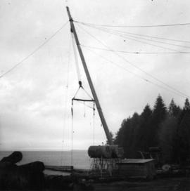
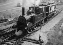
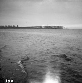
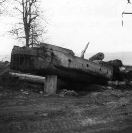
Photograph depicts a once used booming boat made of log sections at a log dump on seashore about 5 miles north of Powell River, and opposite Harwood Island. Stern at left with prop guard.
Photograph depicts a log dump on seashore about 5 miles north of Powell River and opposite Hardwood Island. The view is looking north.
Photograph depicts a lumber yard on the north side of Porpoise Bay in Sechelt on the Sechelt Peninsula. The tank in the photograph is about 8 to 10 feet in diameter.
Photograph depicts a logging bridge over Lois River between Saltery Bay and Lang bay, south of Powell River.
Photograph depicts logging on a side road on the Sechelt Peninsula about 2 miles southeast of Halfmoon Bay.
Photograph depicts a small coal drift mine which worked perhaps 6 months prior to the picture being taken. Timber lands # 8, Cranberry, about 17 miles south of Nanaimo.
Photograph depicts a derelict copper smelter at Princeton, BC. The ore comes from Copper Mountain.
Photograph depicts a derelict gold mine at Hedley, BC.
Photograph depicts the pit head refuse at Extension Coal Mine, 5 miles southwest of Nanaimo. It worked between 1901 and 1931.
Photograph depicts a mine ore car exhibited on the site of the Granby Mine at the ghost town of Phoenix, near Grand Forks.
Photograph depicts a mineral ore (lead or zinc?) mines near the ghost town of Sandon, on the road between Kaslo and New Denver.
Photograph depicts the coking ovens at Union Bay on Vancouver Island. They belong to the Canadian Collieries Ltd. and the date last used is unknown.
Photograph depicts the coaling wharf at Union Bay on Vancouver Island. It is the property of the Canadian Colliery Resources Ltd. It was last used on August 15, 1960. Thereafter, all equipment and railways were dismantled but the water tank is still standing.
Photograph depicts a mine 200 yards south of Moyie village, which is 20 miles south of Cranbrook. It produced silver, zinc, and lead from 1900-1910 and had a smelter a quarter mile away. The shaft was 900 ft. deep, with levels going under Moyie Lake. The head gear dates from 1925-1935 and has electric winding.
Photograph depicts Moyie Lake, 15 miles south of Cranbrook, and Moyie Station. The tailings are from a lead and zinc mine directly to the right of the photograph on the hillside. The view is looking north.
Photograph depicts a mine car at Moyie mine, at Moyie, 20 miles south of Cranbrook. The mine produced silver, zinc, and lead, and worked principally from 1900-1910. It is now disused.
Photograph depicts a derelict shovel beside the coaling wharves at Union Bay.
Photograph depicts a Ruston steam roller owned by Gary Wellburn in Duncan, BCIt was previously owned by the Oak Bay municipality.
Photograph depicts a steam crane at the Allied Shipbuilders Ltd. on 145 West First Ave in Vancouver, BC
Photograph depicts an old pelton wheel at a former quarry at Granite Falls on the northeast head of the Indian Arm.
Photograph depicts a recently used steam crane, but driven by compressed air, at a former quarry at Granite Falls on the northeast end of the Indian Arm. The timbers on of the cabin were thick to withstand the blasting rock falls.
Photograph depicts a 10 ton Wallis & Stevens Ltd. #7985 steam roller. It was built at Basingstoke, England from about 1925 to 1927. It is located at 6110 Curtis St. in Burnaby, BC
Photograph depicts an abandoned coal mine in Coal Creek, 5 miles east of Fernie, BCThe entrance to the mine is unusual and is 2/3rds up the mountainside. The mine was closed in 1959. Flat ground in foreground is littered with at least 100 mine tubs of approximately 3'0' gauge.
Photograph depicts the mine buildings of the mine at Coal Creek that closed in 1959. The newer buildings date to circa 1930. Much of the standard gauge trackage of Morrissey, Fernie, and Michel railway (subsidiary of the Great Northern Railway) in mine area remains. The track between Coal Creek and Fernie has not been lifted.
Photograph depicts the Hedley Gold Mine, 26 miles east of Princeton. Crusher workings.
File consists of documentary photographs taken by David Davies of the forest and lumber industry in British Columbia.
Series consists of research material relating to steam and diesel locomotives that were used on British Columbia railways. Includes information about the steam to diesel transition period, details about specific locomotives, locomotive manufacturers, and self-propelled coaches.
Photograph depicts loading coal at Buckley Bay. Coal is from Tsable Mine belonging to the Comox Colliery Co. The view is looking north.
Photograph depicts a C.P.R. lumber train at Cowichan Lake to go to Crofton Mill on Vancouver Island.
Photograph depicts a C.P.R. wrecking train unit at Vancouver station.
Subseries consists of prints and negatives depicting railways in British Columbia, as well as a small selection of other subjects such as historical ships, buildings, vehicles, and bridges. All photographs created by David Davies.
Series consists of graphic material depicting railways in British Columbia. Includes prints, negatives, and postcards.
The David Davies Railway Collection encompasses all facets of railway history specifically in the province of British Columbia and the Yukon territory. The collection consists of research material accumulated over the course of more than fifty years, and includes monographs, periodicals, articles, clippings, railway timetables, photographs, maps and plans, and excerpts. Material covers public, tourist, and private (industrial) railways, including: CPR, KVR, E&N; CNR, CNoR, GTPR; and PGER, BCR. The collection excludes material regarding streetcar systems and rapid transit, but includes long distance electric interurbans.
Map depicts the route of BC Rail and its connecting rail lines.
Map depicts the routes of the Pacific Great Eastern Railway, showing stations, railway connection, and the PGE Microwave Communication System.
Map depicts the Shuswap Lakes, Rogers Pass, Kamloops, Yellowhead Pass, Thompson Valley, and the Nicola Valley. Also includes the first clues to a treasure hunt.
Map depicts location of treasure hidden between Clearwater and Clemina, BC.
Plan depicts Granville Island industrial sites in False Creek, Vancouver. Shows revised trackage from 1955 annotated in colour by Davies.