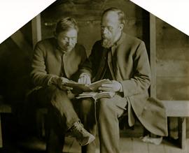
The pair sits with books on bench in unknown room, Collison on right.
Handwritten annotations on verso read: "Archdeacon Collison giving of reading lesson at Kincolith BC"; "'line upon line' or teaching the way of God more perfect [...]"
The pair sits with books on bench in unknown room, Collison on right.
Handwritten annotations on verso read: "Archdeacon Collison giving of reading lesson at Kincolith BC"; "'line upon line' or teaching the way of God more perfect [...]"
Photograph depicts a group of 18 men wearing suits and ties, standing on front steps of large building with pillars.
Handwritten annotation on verso reads: "Conference of Sand Question Committee at Kincolith on Sunday, June 3rd 1923. Mr. [O'Heara?] present. [illegible initials]".
Donald Macdonald and John Maxwell Collison stand on either side of large log using two-handled saw. Donald married the Archdeacon's daughter Emily in 1910.
Handwritten annotation on verso reads: "Uncle Don, Uncle Max & Grandad Hauling wood off [beach?] at Kincolith".
Village can be seen in distance. Large church building stands in centre, hills in background.
Handwritten annotation on verso reads: "Grand Dad on beach at Kincolith".
Village can be seen in distance. Large church building stands in centre, hills in background.
Handwritten annotation on verso reads: "For heading of Page 18. Kincolith or 'The Rock of Scalps.' Section of Kincolith [...]"
Handwritten annotation on verso reads: "Old church - Kincolith Nass River BC".
Chicken wire crosses foreground, hills visible in background.
Photograph depicts large church building behind white fence. Other buildings visible in background.
Handwritten annotation on verso reads: "New Church Kincolith Nass River BC".
Photograph depicts tall building, with long shorter section crossing midground in front. Path runs through garden in foreground.
Handwritten annotation on verso reads: "Back of Mission House Kincolith".
Photograph depicts a tomb elevated over grassy area.
Handwritten annotation on image reads: "26. Front of Indian tomb."; on verso: "Upper Nass River."
Photograph depicts large church to left of a tower structure. Power lines cross foreground, and other buildings can be seen in background.
Handwritten annotation on verso reads: "New Church Kincolith Nass River BC".
Photograph depicts two unidentified men sitting on front steps of large church. Building materials are scattered in foreground, and scaffolding is visible on one tower.
Handwritten annotations above and below image read: "Dimensions of 73 Feet in length by 37 Feet in width exclusive of Porch and Buttresses. Destroyed by fire with 30 dwelling houses. The spire had been completed when burnt."; "Kincolith Church, Nth. W. Coast. British Columbia within 5 miles of the Alaskan Coast, was destroyed by fire"
Greeting card reads: "Kincolith Church. Wishing you all a very happy Xmas. Your work shall be rewarded. II Chron. XV. 7. [illegible initials]".
Buildings visible on shore in distance.
Handwritten annotation on verso reads: "Amidst drift ice on Fishing Bay Nass River. Insert at Page 38. Indian Fishing Encampment".
Photograph depicts two men handling fishing net in canoe full of fish. Hills visible on opposite shore in distance.
Handwritten annotation on verso reads: "Oolichan Fishing on Nass River".
Photograph depicts an empty canoe floating beside a canoe full of fish. Hills visible on opposite shore in distance.
Handwritten annotation on verso reads: "Loaded with fish - Nass River".
Photograph depicts two men standing beside beds of fish laid out to dry. More oolichan fish hang on tall structures in background.
Handwritten annotation on verso reads: "Oolichan drying & [?] grease at Fishing Bay Nass River 'Winter food supply'".
Photograph depicts two men standing beside beds of fish laid out to dry. More oolichan fish hang on tall structures in background.
Handwritten annotation on verso reads: "'Food for winter' Oolichans drying at Fishing Bay, Nass River".
Photograph depicts groups of men gathered on ice. One man sits on ice sled in foreground. Village can be seen on shore in background.
Handwritten annotation on verso reads: "Chapt. II. No. 1. Fishing Bay. Olachan fishery on the ice."
Photograph depicts a group of men gathered around hole in ice. Two men in centre handle a net full of fish. Village can be seen on shore in background.
Handwritten annotation on verso reads: "Oolichan Fishing Nass River".
Photographs depict groups of men gathered on ice. Herbert leans over behind two friends seated on ice sled (son of Marion and Archdeacon W.H. Collison). Pile of caught fish can be seen in foreground behind large whole in ice.
Handwritten annotations on verso read: "Oolichan Fishing Fishing Bay Nass River"; "Uncle Herbert with Indian friends fishing for oolichan through the ice."
Handwritten annotation on verso reads: "Poling supplies up Nass River".
Three men can be seen carrying bundles across bridge above river, forest on shore in background.
Handwritten annotation on verso reads: "Upper Nass River. Chapt. XXII. No. 4. An Indian Bridge on a canyon."
Photograph features a steep cliff across water, rocky shore in foreground.
Handwritten annotation on verso reads: "Up the 'Big Creek' at Kincolith B.C. Rock face called 'the place of echoes' by the Indian people."
Photograph features a steep cliff across still water.
Handwritten annotation on verso reads: "Place of Scalps / Kincolith BC"
Arthur Collison stands behind large fish hung from wood shelter, Noah seated in foreground. Arthur is the youngest son of Marion and Archdeacon W.H. Collison.
Handwritten annotation on verso reads: "Arthur Collison with our friend 'Noah' with catch - at Kincolith Nass River".
Three men stand in centre, each wearing a chief's dress and head-dress. Family members stand and sit on either side. Carved boxes and masks are positioned in foreground. The group poses in front of drapery hung against tall wooden wall.
Community members have stated that the people in this photo are from the Gitwilluyaxw clan from the wolf tribal house of Ksdiyaawak. The photo was taken at Gitlax̱t’aamiks along the Nass River.
Handwritten annotation on verso reads: "Tsimpshian Chiefs & family. Goods [for or fr.] Potlatch".
Photograph depicts two men standing at base of totem pole in front of large elaborate lodge building with post reading "MINESQU". Smaller structure stands in background (elevated cache?).
Handwritten annotation on verso reads: "Chapter XXIV. No. 3. A chief's lodge and totem Nass River."
File consists of project planning documents for the BC Ministry of Environment's "Upper Nass Assessment Project", a project that included the biophysical mapping of the Northwest-Klappan Road Access Area. Grant Hazelwood (Alpenglow Resources) was hired as the wildlife biologist for to undertake this project work. Includes Hazelwood's employment information for the project, project terms of reference, and a project summary.
File consists of Grant Hazelwood's notes and collected correspondence created in conjunction with the BC Ministry of Environment's "Upper Nass Assessment Project", a project that included the biophysical mapping of the Northwest-Klappan Road Access Area. Includes a summary document entitled "Klappan Access Road Project - Wildlife Component", as well as Hazelwood's handwritten species inventory notes.
File consists of an original copy of the "Task Force on Northwest Economic Development Opportunities - Environmental Overview - Technical Background Report" from October 1983. Also includes an accompanying memoranda note from 1984 regarding the report.
File consists of a copy of "Preliminary Environmental Assessment of Railway Corridor Options to Service Mount Klappan Coal Project and the Northwest Region of British Columbia" (1984) by the Industrial and Energy Project Evaluation Section, Planning and Assessment Branch of the BC Ministry of Environment.
File consists of an original "Mount Klappan Anthracite Project" document by Gulf Canada Resources Ltd. Includes accompanying map entitled "Gulf Canada Resources Inc.: Northwest British Columbia" that shows proposed coal mine sites in the Mount Klappan area, near Spatsizi Wilderness Park and Tatlatui Provincial Park.
File consists of an original "Mount Klappan Access Road Study" proposal for consulting services to the BC Ministry of Industry and Small Business Development by Phillips Barratt Kaiser Engineering Ltd. in association with Associated Engineering (B.C.) Ltd.
File consists of a photocopied report by BC Ministry of Environment wildlife habitat biologist Dan Blower entitled "Preliminary Wildlife Assessment of Klappan Coal Road Alternatives" from April 19, 1985.
File consists of a photocopied "Preliminary Environmental Assessment of Corridor Alternatives for the Proposed Mount Klappan Coal Project". Includes accompanying memoranda regarding the report.
File consists notes, correspondence, summary reports, inventory data, and a map regarding capability classification for Bowser Lake. The map is a "clean copy" of Grant Hazelwood's ungulate biophysical map without symbols. Summary reports include:
The Church Missionary Intelligencer. New Series. 1 September 1873
Series consists of images pertaining the Collison family, North Coastal First Nations communities, means of transportation along North Coastal British Columbia, and various church structures and religious events.