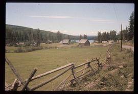
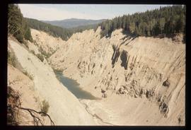
Image depicts the Bullion Pit in Likely, B.C. It is a man-made canyon from the days of the gold-rush, formed by the use of hydraulic monitors. The gold-mine operated from 1892 to 1942.
Image depicts an old, half-collapsed house in Likely, B.C.. The slide labels it as "Bullion house."
Image depicts a field of hay somewhere in Beaver Valley.
Image depicts the Cariboo Lake, with the roof of an old log cabin visible.
Image depicts the Cariboo River.
Image depicts the old log buildings of the town of Hydraulic, B.C.
Image depicts a bridge, and the town of Likely on the the other side of a river.
Image depicts the town of Horsefly, B.C.
Image depicts a cemetery in the South Fort George suburb of Prince George, B.C.
Image depicts a bridge in Prince George, B.C.
Image depicts the Lheidli T'enneh Burial Grounds in Fort George Park.
Image depicts a view of Prince George from an uncertain location.
Image depicts an uncertain street in Prince George, B.C.
Image depicts Prince George with numerous trees obscuring most of the view.
Image depicts Prince George.
Image depicts the Lheidli T'enneh Burial Grounds in Fort George Park.
Image depicts the Fraser River at Paddlewheel park, with a train on the other side of the river, in Prince George B.C.
Image depicts a view of Prince George.
Image depicts the frozen Morfee Lake just to the East of Mackenzie, B.C. The slide is also labelled "sub-boreal," referencing that it is a sub-boreal spruce zone.
Image depicts the Mackenzie Reservoir in Mackenzie, B.C.
Image depicts several apartment buildings and the sign for a Gulf Gas Station in Mackenzie, B.C.
Image depicts a truck parked on a beach in Mackenzie, B.C.
Image depicts the Germansen River, with the buildings of Germansen Landing visible on the other side.
Image depicts a camper parked on the shore of Nation Lakes, south of Manson Creek, B.C.
Image depicts a bridge over the Nation River somewhere south of Manson Creek, B.C.
Image depicts the Nation River somewhere south of Manson Creek, B.C.
Image depicts the road to Manson Creek, B.C.
Image depicts a man and his family filling up their truck with gas at Manson Creek, B.C.
Image depicts Manson Creek, B.C.
Image depicts the gas station at Manson Creek, B.C.
Image depicts a creek with a half collapsed shack in the background somewhere in Manson Creek. The slide is labelled "Manson workings."
Image depicts a bridge over the Omineca River near Germansen Landing, B.C.
Image depicts a helicopter in Germansen Landing, B.C.
Image depicts a child in the foreground, and the Germansen Landing trading post in the background in Germansen Landing, B.C.
Image depicts the McGregor River at an uncertain location.
Image depicts a view of McGregor Valley from an uncertain location.
Image depicts a red vehicle parked on the side of the road with a view of the McGregor Valley behind it. The slide is labelled "dam site."
Image depicts a view of the McGregor Valley.
Image depicts the McGregor River at an uncertain location.