Showing 3026 results

Archival description
A Shed?
2012.13.1.87.114 · Item · [between 1970 and 1990]
Part of J. Kent Sedgwick fonds

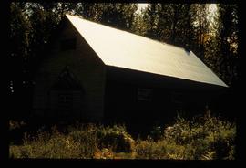
Image depicts what appears to be a shed at an uncertain location.

A Church
2012.13.1.87.113 · Item · [between 1970 and 1990]
Part of J. Kent Sedgwick fonds

Image depicts a church at an uncertain location.

A Kitchen
2012.13.1.87.110 · Item · [between 1970 and 1990]
Part of J. Kent Sedgwick fonds

Image depicts the interior of a kitchen at an uncertain location.

A Classroom
2012.13.1.87.109 · Item · [between 1975 and 1995]
Part of J. Kent Sedgwick fonds

Image depicts the interior of a classroom at an uncertain location.

Sawmill Town?
2012.13.1.87.106 · Item · [between 1975 and 1995]
Part of J. Kent Sedgwick fonds

Image depicts numerous buildings at an uncertain location. A beehive burner and what appears to be a large pile of wood is visible in the background.

Willow River Houses
2012.13.1.87.105 · Item · [between 1975 and 1995]
Part of J. Kent Sedgwick fonds

Image depicts a snowy street in Willow River, B.C. with a row of houses. The white building on the end with the Pepsi sign is the Willow River General Store. Map coordinates 54°04'18.3"N 122°28'14.7"W

2012.13.1.87.104 · Item · [between 1975 and 1995]
Part of J. Kent Sedgwick fonds

Image depicts a snowy street in Willow River, B.C. There are several buildings, one is an Esso station and another is labelled as "Red & White Food Store."

Snowy Road
2012.13.1.87.103 · Item · [between 1975 and 1995]
Part of J. Kent Sedgwick fonds

Image depicts a snowy road at an uncertain location.

Driveway in Newlands, BC
2012.13.1.87.102 · Item · [between 1975 and 1995]
Part of J. Kent Sedgwick fonds

Image depicts a driveway cordoned off by a red mesh material in Newlands, B.C. The address of the house is labelled 31951, and the name listed is "Fauchers." Map coordinates 54°06'47.8"N 122°08'22.4"W

Buildings in Newlands, BC
2012.13.1.87.101 · Item · [between 1975 and 1995]
Part of J. Kent Sedgwick fonds

Image depicts several old buildings in a field, one of which has a caved-in roof, in Newlands, B.C. Map coordinates 54°06'28.2"N 122°12'01.0"W

Giscome - Church
2012.13.1.87.099 · Item · [between 1975 and 1995]
Part of J. Kent Sedgwick fonds

Image depicts a church in Giscome, B.C. Map coordinates 54°04'16.2"N 122°21'54.3"W

Giscome - Power Poles
2012.13.1.87.098 · Item · [between 1975 and 1995]
Part of J. Kent Sedgwick fonds

Image depicts the remains of a street of houses in Giscome, B.C. The quarry is slightly visible in the background. Map coordinates 54°04'20.9"N 122°21'53.1"W

Street in Giscome - After
2012.13.1.87.094 · Item · [between 1980 and 2000]
Part of J. Kent Sedgwick fonds

Image depicts a street in Giscome. The store was previously located on the left. The church is in the background. Map coordinates 54°04'18.5"N 122°21'57.7"W

Street in Giscome - Before
2012.13.1.87.093 · Item · [between 1980 and 2000]
Part of J. Kent Sedgwick fonds

Image depicts a street in Giscome B.C. The Giscome Store is located on the left side of the image with the church in the background. Map coordinates 54°04'18.5"N 122°21'57.7"W

Giscome - Eaglet Lake
2012.13.1.87.090 · Item · [between 1980 and 2000]
Part of J. Kent Sedgwick fonds

Image depicts mill site and dock in Giscome, B.C. with Eaglet Lake in the background covered in ice. There is a large crowd of people gathered near the dock. Map coordinates 54°04'34.9"N 122°21'50.0"W

2012.13.1.87.087 · Item · [between 1975 and 1995]
Part of J. Kent Sedgwick fonds

Image depicts the Giscome mill site in Giscome, B.C. The railroad tracks are in the foreground. Map coordinates 54°04'17.6"N 122°22'06.1"W

2012.13.1.87.086 · Item · [between 1980 and 2000]
Part of J. Kent Sedgwick fonds

Image depicts the Giscome mill site in Giscome, B.C. The bunkhouse is the large building with many windows. A train and railroad tracks are in the foreground. Map coordinates 54°04'17.6"N 122°22'06.1"W

Giscome School - After
2012.13.1.87.085 · Item · [between 1975 and 1995]
Part of J. Kent Sedgwick fonds

Image depicts the Giscome mill site in Giscome, B.C. The bunkhouse is no longer there and the school is in the foreground on the right. Map coordinates 54°04'04.8"N 122°22'04.7"W

Giscome School - Before
2012.13.1.87.084 · Item · [between 1980 and 2000?]
Part of J. Kent Sedgwick fonds

Image depicts the Giscome mill site in Giscome, B.C. The bunkhouse is in the background on the left and the school is in the foreground on the right. Map coordinates 54°04'04.8"N 122°22'04.7"W

Giscome Dairy Farm
2012.13.1.87.083 · Item · [between 1975 and 1995]
Part of J. Kent Sedgwick fonds

Image depicts a large, old and collapsing barn, as well as a nearby house of the dairy farm in Giscome, B.C. Map coordinates 54°03'53.3"N 122°21'22.6"W

Eaglet Lake?
2012.13.1.87.082 · Item · [between 1975 and 1995]
Part of J. Kent Sedgwick fonds

Image depicts a lake at an uncertain location, likely Eaglet Lake.

House - Elevated Main Floor
2012.13.1.87.079 · Item · [between 1975 and 1995]
Part of J. Kent Sedgwick fonds

Image depicts a house with the main floor and entrance high off the ground. The location is uncertain, likely Giscome, B.C.

Giscome Quarry
2012.13.1.87.074 · Item · [between 1975 and 1995]
Part of J. Kent Sedgwick fonds

Image depicts what is possibly the quarry located at Eaglet Lake in Giscome, B.C.

Houses and Train in Giscome
2012.13.1.87.073 · Item · [between 1975 and 1995]
Part of J. Kent Sedgwick fonds

Image depicts the Giscome B.C. townsite from across the railroad tracks looking southeast. Map coordinates 54°04'19.7"N 122°22'04.7"W

Houses in Giscome
2012.13.1.87.072 · Item · [between 1975 and 1995]
Part of J. Kent Sedgwick fonds

Image depicts the Giscome B.C. townsite from across the railroad tracks looking southeast. Map coordinates 54°04'19.7"N 122°22'04.7"W

Giscome Landscape
2012.13.1.87.071 · Item · [between 1975 and 1995]
Part of J. Kent Sedgwick fonds

Image depicts an open area with Eaglet Lake in the background. It depicts the previous site of the mill at Giscome, B.C. Map coordinates 54°04'19.7"N 122°22'04.7"W

Open Field in Giscome
2012.13.1.87.069 · Item · [between 1975 and 1995]
Part of J. Kent Sedgwick fonds

Image depicts a field in Giscome, B.C. On the right side of the image, in the background, is a grey strip that appears to be a mine, possibly the quarry at Eaglet Lake in Giscome, B.C. Map coordinates 54°03'52.9"N 122°22'10.0"W

Open Field in Giscome
2012.13.1.87.068 · Item · [between 1975 and 1995]
Part of J. Kent Sedgwick fonds

Image depicts a field in Giscome, B.C. On the right side of the image, in the background, is a grey strip that appears to be a mine, possibly the quarry at Eaglet Lake in Giscome, B.C. Map coordinates 54°03'52.9"N 122°22'10.0"W

2012.13.1.87.067 · Item · [between 1975 and 1995]
Part of J. Kent Sedgwick fonds

Image depicts a row of buildings in Upper Fraser, B.C. with the store (titled "Paradise") with a Pepsi sign. Map coordinates 54°07'09.1"N 121°56'47.0"W

Upper Fraser Mill
2012.13.1.87.066 · Item · [between 1975 and 1995]
Part of J. Kent Sedgwick fonds

Image depicts the Upper Fraser Road running through Upper Fraser, B.C. A newer style round burner is seen in the background. Map coordinates 54°07'05.7"N 121°56'38.9"W

2012.13.1.87.065 · Item · [between 1975 and 1995]
Part of J. Kent Sedgwick fonds

Image depicts an old house for sale surrounded by overgrown bushes in Upper Fraser, B.C. Map coordinates 54°07'15.0"N 121°57'02.0"W