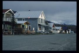
Showing 2440 results

Archival description
2097 results with digital objects Show results with digital objects
Atlin - Nurses' Residence
2012.13.1.98.21 · Item · 1999
Part of J. Kent Sedgwick fonds

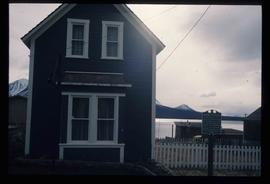
Image depicts a building which once served as the residence for two nurses in Atlin, B.C. A sign in front of the house reads: "Grateful Atlinites built this house in 1902 for their first missionary nurses, Helen Bone and Elizabeth Mitchell, who came here in 1899 and lived in a crude shack while valiantly and humanely caring for sick and dying pioneers."

Atlin Lake
2012.13.1.98.14 · Item · 1999
Part of J. Kent Sedgwick fonds

Image depicts Atlin Lake as well as a small section of Atlin, B.C. The mountain is possibly Atlin Mountain.

The Tutshi
2012.13.1.98.06 · Item · 1999
Part of J. Kent Sedgwick fonds

Image depicts half of a ship, which is named the Tutshi, in Carcross, Y.T.

Railway Bridge
2012.13.1.98.03 · Item · 1999
Part of J. Kent Sedgwick fonds

Image depicts a railway bridge, possibly in the small town of Fraser, located on the Klondike Highway in B.C.

Road to Skagway
2012.13.1.98.01 · Item · 1999
Part of J. Kent Sedgwick fonds

Image depicts the road to Skagway, Alaska. Possibly located on the Klondike Highway in British Columbia with Tutshi Lake on the left.

View of Pine Pass
2012.13.1.93.55 · Item · 1978
Part of J. Kent Sedgwick fonds

Image depicts a view of Pine Pass on the border between Alberta and British Columbia in the Rocky Mountains.

Bare Trees
2012.13.1.93.35 · Item · 1978
Part of J. Kent Sedgwick fonds

Image depicts a forest of bare trees, possibly somewhere near Fort St. John, B.C.

Group and a Bus
2012.13.1.93.34 · Item · 1978
Part of J. Kent Sedgwick fonds

Image depicts a group of individuals and a bus with words that read: "Prince George Limousine & Charter." The river in the background is possibly the Peace River, and the location is possibly somewhere near Fort St. John, B.C.

2012.13.1.93.29 · Item · 1978
Part of J. Kent Sedgwick fonds

Image depicts numerous pieces of what appears to be old farming equipment. There is also an unidentified individual sitting aginst the side of a building. The location is possibly Fort St. John, B.C.

Peace River
2012.13.1.93.27 · Item · 1978
Part of J. Kent Sedgwick fonds

Image depicts the Peace River and visible layers of sediment deposits in the surrounding cliffs.

Examining Rocks
2012.13.1.93.21 · Item · 1978
Part of J. Kent Sedgwick fonds

Image depicts three unidentified individuals examining rocks near a set of railway tracks at an uncertain location in the Peace River Region.

Parking Lot Frisbee
2012.13.1.93.18 · Item · 1979
Part of J. Kent Sedgwick fonds

Image depicts a group of people throwing a frisbee in a parking lot at an uncertain location, likely in the Peace River Region.

Sunset
2012.13.1.93.03 · Item · 1978
Part of J. Kent Sedgwick fonds

Image depicts a view of a sunset at an uncertain location, possibly in the Peace River Region.

Houses and a Ballpark
2012.13.1.93.01 · Item · 1978
Part of J. Kent Sedgwick fonds

Image depicts a view of numerous houses and a ballpark at an uncertain location. It is possibly located somewhere in the Peace River Region.

People and a Bridge
2012.13.1.91.50 · Item · 1979
Part of J. Kent Sedgwick fonds

Image depicts several unidentified individuals and a bridge behind them; it is possibly crossing the Peace River.