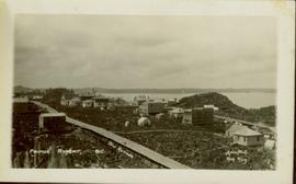
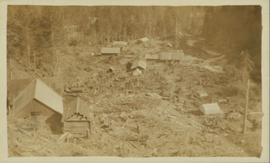
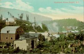
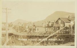
Close up photograph of a large residential building in a freshly clear cut area. To the right of the main building is the church and an unidentified commercial building. Annotation on recto reads: "Prince Rupert, BC 1660."
Wide angle photograph showing 3rd and 2nd Avenue in Prince Rupert. Many buildings, both commercial and residential, and some tents are situated along the wooden roads. Annotation on recto reads: "Prince Rupert, BC. 3rd Avenue 2nd Avenue Allen Photo Aug 6/09."
Gathering of tents in Vickersville with the harbour and mountains in the distance. Annotation on recto reads: "Vickersville Prince Rupert o/n[?] 1908."
Wide angle photograph of Prince Rupert sometime during the winter. There is snow on the ground and a marge mountain range is visible in the background. Annotation on recto reads: "Prince Rupert looking East from Waterworks J.D.A Pho 5/2."
Wide angle photograph showing the intersection of 3rd Avenue and 6th Street, as well as 5th Street in Prince Rupert. Many buildings are visible along the wooden street including a building in mid-construction. Annotation on recto reads: "Prince Rupert, BC. 6th Street 3rd Ave. 5th St Allen Photo Aug 6/09."
View of the road descending to the waterfront. Buildings and forested area are visible on either side of street. Annotation on recto reads: "Prince Rupert BC. '07."
Photograph of post office and neighbouring building. Both buildings are composed of wood and tent materials. Annotation on recto reads: "Post Office & Customs House, Prince Rupert, BC."
Series consists of journals, draft manuscripts, correspondence, CMS documents and orders, speeches, sermons all written by or to Archdeacon W. H. Collison. Series also contains correspondence to W.E. Collison and Joyce Collison, genealogical information on the Collison family, newspaper clippings and a school paper written by Archdeacon Collison's grandaughter Katy.
Photograph of two men posing next to a four-legged post erected in the wilderness. Printed annotation on recto reads: "Boundery[sic] Post Alaska & BC. Hughes #42."
Street view of downtown Stewart, BC. Photograph shows boards propped up over the swampy area of the future road. Wood debris litters the foreground.
Photograph of two men relaxing on some short exterior stars. A surveying transit can be seen in the background.
Photograph of two men posing with large surveyor's measuring sticks in a forested area during winter.
Photograph of a happy man reclining on a short exterior staircase. A surveyor's transit can be seen in the background.
Photograph is a printed postcard depicting scattered small buildings and a tent. Trees have been removed from the area around the buildings and many stumps remain.
Photograph is a printed postcard depicting a wagon track between buildings situated on either side. There are mountains in the back ground. Possibly Stewart, BC.
Hand coloured photo of various squatter's shacks and tents, with mountains in the background. Printed annotation on recto reads: "Squatters, Prince Rupert, B.C." Artist's stamp on lower right corner reads: "104,0033 J.V."
Hand coloured lofty view of the Prince Rupert waterfront. Printed annotation on recto reads: "The Beginning of Prince Rupert, B.C. : Grand Trunk Pacific Hotel in foreground." Artist's stamp in lower left corner reads: "104,036 J.V."
Street view of 5th St. in Prince Rupert BC. The dirt road is flanked by two partially demolished rock faces. Printed annotation on recto reads: "5th St Prince Rupert, B.C."
Wide angle view of Borden Street in Prince Rupert. Many residential buildings line the wooden road with railing. Printed annotation on recto reads: "Borden Street. Prince Rupert B.C."
Street view of Centre Street in Prince Rupert, BC. Buildings are in various states of construction. Printed annotation on recto reads: "Centre St Prince Rupert B.C. June 20/08 JDA.""
Slightly elevated street view of buildings and sidewalks being constructed in Prince Rupert, BC. Printed annotation on recto reads: "Photo by McRae Bros. Third Ave Prince Rupert, BC." Handwritten annotation on verso reads: "Dear Florence you better [illegible] will try and answer it in a few day I am well I will try and send you some cards I will stay here till in Dec Write[??] me and send me some cards I am 15 mile in the mountains Write your Bro LS Bill." Postcard is addressed to: "Miss Florence Wilson P.O. Box 1178 Worcester Mass U.S.A." A 2 cent Canadian stamp is affixed on verso. Postmark reads: "Prince Rupert BC Jul 1 10."
Photograph of a large explosion next to a huge pile of debris. Buildings are visible on either side and railroad track can be seen in the foreground. Printed annotation on recto reads: "The Last Big Blast, Prince Rupert BC 21 Jan 1914 McRae Bros. Photo"
Photograph of a large explosion on a rocky shoreline. A bridge is visible in the foreground and a body of water is partially visible in the background. Printed annotation on recto reads: "McRae Bros Moving Mountains at Prince Rupert BC Apr 24th" Handwritten annotation on verso reads: "Rupert. July 17 1913. Dear [illegible]. Just a card for that album if you've got any room left by now. This is one of the blasts for the clearing of the drydock up here. [Illegible] W.M." Postcard is addressed to: "Miss C.M. Ranip[??] 931 Northlane Av.[sic] Seattle Wash." Two Canadian one cent stamps are affixed on verso. Postmark reads: "Prince Rupert BC. PM Jul 17 13."
Photograph of a large explosion on what appears to be a shoreline. Printed annotation on recto reads: "'Big Blast' Prince Rupert. B.C."
Head on photograph of a trapper standing in front of his cabin in Prince Rupert, BC. The front of the cabin is covered in various pelts. Printed annotation on recto reads: "A Trappers Cabin near Prince Rupert."
Photographs within this file document stern wheelers operating in Northern BC from ca. 1901 - 1915.
Kent Sedgwick’s research subject files contain original research notes, interviews and oral histories, news clippings, and collected primary and secondary sources. The series also includes both original and reproduction photographs, audio recordings, and maps. The subject files primarily relate to the history, urban planning, and historical geography of the Central Interior of British Columbia, especially Prince George area and the East Line communities over the course of the 20th century. They also include extensive notes on geographic features, landscapes, interpretative trails, architectural history, industrial history, history of Western exploration and land survey, and the First Nations history of the region.
File consists of clippings, notes, and reproductions relating to the incorporation of the city of Prince George. Includes: "Looking back 90 years" in Prince George Citizen Saturday Report (5 Mar. 2005); "Prince George Public Library Historical Costume Workshop - 1915" Workshop description by Jannice Closson (Jan. 1990); "The Three Georges" maps of Prince George, Fort George, and South Fort George at Incorporation of the city of Prince George in 1915 (Feb. 2000); "Incorporation dates" notes by Sedgwick on the incorporation of Prince George dates; and a photocopy of the Fort George Incorporation Act, "An Act to Incorporate the City of Fort George" (6 Mar. 1915).
File consists of clippings, notes, and reproductions relating to the naming of the city of Prince George and the origins of the name. Includes: "Proclamation" photocopy of British Columbia Gazette discussing the naming of the city of Prince George (1915); "Prince George needs a new name" print of pgcitizen.ca article by Neil Godbout including comments on the article (July 2009); "Prince George" in Prince George Citizen, Northern Explorer (May 2006); and "History of Prince George" in a Prince George Towncenter Business Association publication (July 1985).
Subseries includes research material created and collected by Kent Sedgwick relating to land survey, development, and settlement in Prince George and British Columbia. Land surveys were conducted in British Columbia by surveyors George Dawson, the North Coast Land Company, Alfred R.C. Selwyn, and the Geological Survey of Canada during the late 19th and early 20th centuries. James C. Anderson and engineer J. Gill conducted topographical surveys for the Grand Trunk Pacific Railway on Fort George and the Indian Reserve. Surveyors and land plot companies developed the land for sale to promote settlement in the area. Also includes materials regarding the continued development of the City of Prince George throughout the 20th century. The files primarily consist of newspaper clippings, research notes, and photocopied documents.
The item is a reproduction of a section of survey map drafted on 18 March 1915 and revised on 23 May 1916. The reproduction was likely created in 1990. The Plan Number is 1268 and highlights the area along the Nechako and Fraser Rivers. The map details subdivisions East of Carney Street, North of Twentieth Avenue and South of Ninth Avenue. Annotations in pencil state different map scale variations and "cemetery setback."
The item is a reproduction of a section of survey map drafted in 1915. The reproduction was likely created in 1990. The Plan Number is 1268 and highlights the area along the Nechako River. The map details subdivisions East of Carney Street and North of Fifth Avenue. Some original street and avenue names have been crossed out and replaced with handwritten names. Annotation on reverse side of map states, "D.L. 343 Pl. 1268."
The item is a reproduction of a survey map drafted on 1 March 1910. The reproduction was likely created in 1990. The area highlighted is along the Fraser River. The map details subdivisions East of Ninth Street and South of Thapage Lane. Land Surveyor J. F. Templeton certified the plan. Annotation on the map states, "Pl. 727."
The item is a reproduction of a survey map drafted in January 1910. The reproduction was likely created in 1990. The subdivision is Lot 936 G. I. Cariboo District, B.C. The area covered is North of Twenty First Avenue, East of Quinn Street, South of Eighth Avenue and West of Carney Street. Annotations highlight "Owner Edgar McMickiny," "696" and "Jordan Brothel" written in red pen pointing to a specific location.
The item is a reproduction of a survey map drafted in September 1909. The reproduction was likely created in 1990. The annotations highlight owners of different lots up to approximately 1959. Th area covered is North of Fifteenth Avenue, East of Irwin Street, South of Eighth Avenue and West of Carney Street. Annotations on attached papers indicate different means of scale and measurement for the map.
The item is a reproduction of a survey map drafted in approximately 1911 and revised in May 1914. The reproduction was likely created in 1990. The annotation states, "Plan 1391" and is circled in red ink. The area covered is along the Nechako and Fraser Rivers and Northeast of First Avenue.
The item is a reproduction of a survey map drafted on 10 July 1956 and registered on 31 Oct. 1956. The reproduction was likely created in 1990. The plan number is 7782.
The item is a reproduction of a survey map drafted in July 1914. The reproduction was likely created in 1990. The area covered is along the Fraser River and east of Guelph Street. Annotations state, "PL 1409 D. L. 417 HBCo." and highlight different scales of measurement and changed street names.
The item is a reproduction of a survey map drafted in 1 Oct. 1913. The reproduction was likely created in 1990. The area covered is along the Fraser River and west of Linooln Avenue, south of Jackson Street and North of McKinley Street. Annotations state which maps and lots are adjacent to this one. An illegible signature is highlighted.
The item is a reproduction of a survey map drafted June 1912. The reproduction was likely created in 1990. The area covered is Central Fort George, South of 5th Street, East of Alden Avenue, North of 12th Street and West of Fraser Street. Annotations state, "Plan 1085 Carney Addition."
The item is a reproduction of a survey map drafted on 20 Nov. 1910. The reproduction was likely created in 1990. The subdivision is lot 2610 G. I. and part of lots 2507 and 2608 G. I. Cariboo District. The area covered is South of 8th Avenue, East of 19th Avenue, North of 8th Street and West of Quinn Street. Annotations state, "Pl. 847," and various notations regarding lot information.
The item is a reproduction of a survey map drafted on 29 Oct. 1910. The reproduction was likely created in 1990. The area covered is South of Princess Street, East of James Avenue, North of 8th Street and West of Rupert Avenue. Annotations state, "Jesse Hodgeson Crown grand in 1910 for $800..."
The item is a reproduction of a survey map likely drafted in the 1910s. The reproduction was likely created in 1990. The area covered is South of Baillie Street, East of 22nd Avenue, North of Princess Street and West of 7th Avenue. Annotations state, "Pl. 833" and various lot descriptions.
The item is a reproduction of a survey map drafted on 27 July 1910. The reproduction was likely created in 1990. The area covered is South of Reserve Avenue, East of Victoria, North of Bird Avenue and West of 9th Street. Annotations state, "#796" and highlight the date and registered owner.
The item is a reproduction of a survey map likely drafted in the 1910s. The reproduction was likely created in 1990. The area covered is South of Anderson Street, East of Simpson Street, North of Van Bien Avenue and West of 9th Street. Annotations state, "Pl 721 DL 1426."
The item is a reproduction of a survey map drafted on 1 March 1910. The reproduction was likely created in 1990. The area covered is South of Bernhardt Avenue, East of Simpson Street, North of the Fraser River and West of 9th Street. Annotations state, "DL 1426 Plan 721."
The item is a reproduction of a survey map drafted in 1909. The reproduction was likely created in 1990. The area covered are lots 931 and 417. Annotations state, "Plan 701," and various names are highlighted.
The item is a reproduction of a survey map drafted in 1909. The reproduction was likely created in 1990. The area covered is South of Fort George Avenue, East of Fraser Street, North of Mount Stephen Avenue, and West of Simpson Street. Annotations state, "Pl. 649."