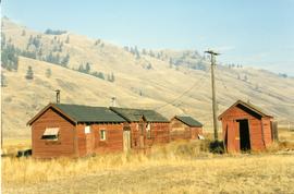
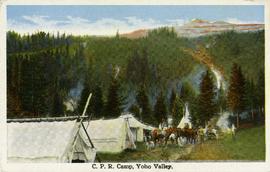
Postcard taken along the CPR line, at a camp in Yoho Valley.
Photograph taken about halfway between Summerland and Princeton.
Photograph taken near Princeton. Looking west, just before dropping into a big loop.
Photograph depicts KVR (CPR) trackage between Boundary Falls and Midway. The line had not yet been officially abandoned, but it was little used, if not at all.
Photograph depicts a terminus of a boundary Subdivision on mile 126.6 from Nelson.
Photograph taken between Summerland and Princeton. Depicts the beginning of the drop into Princeton Valley, just before a big loop.
Photograph depicts the top of the grade coming out of Princeton, going east to Penticton.
Photograph depicts one of the CPR loop on the 'big loops' near Princeton, on KVR trackage.
Photograph depicts a CPR spur line (located on the right), running off from the 'main line' that went from Princeton to Penticton. The spur led to a sawmill.
Photograph depicts KVR track in Princeton.
Photograph depicts what was once part of Nicola branch. It was later truncated to a spur for oil tanks. At the time the photograph was taken, it was abandoned altogether.
Photograph taken looking downgrade at CPR track, east of Princeton.
Photograph taken east of the CPR depot in Princeton.
Photograph taken at CPR Myra Canyon. On the 'Save the Trestles' expedition after a line closure at the location.
Photograph taken in front of the 'main line' that led to a pulp mill and river crossing. To the left was a lesser used connector to the CN main line. Behind the camera was a 4-track interchange yard. Beyond that, the CN line to Alberta could be found.
Photograph taken on a 40 ft. high embankment. Looking towards Fraser River. Northwood Pulp and Timber Ltd. in western direction. All trackage owned and built by the mill. Constructed in 1966.
Photograph depicts a switcher running towards a CN interchange. Just left the Fraser River bridge. All private and owned by Northwood Pulp and Timber Ltd.
Photograph depicts a private rail/road bridge built to serve Northwood Pulp and Timber, Ltd. Crossing Fraser River. Looking west, towards the mill. On private Northwood trackage.
Photograph taken at the Northwood Pulp and Timber Ltd, Prince George. Visible is a General Motors switcher, built in 1959. Aqcuired in 1981. Its sister locomotive had just returned from some major servicing at CN shops in P.G. Built in 1954 and acquired in 1989. Would not be used until business picked up. Pulp trade in world doldrums at the time the photograph was taken.
Photograph taken at the Northwood Pulp and Timber Ltd, Prince George. Visible is a General Motors switcher, built in 1959. Aqcuired in 1981. On private Northwood trackage with the mill in the background.
Photograph depicts Northwood Pulp and Timber Ltd, Prince George. Located north of the city, near the BC Rail and CNR mainline tracks. It had its own railway of about 5 miles in length and two diesel switchers.
Photograph depicts a pump car that was property of Kamloops Heritage Railway. Viewed at the downtown CNR station in Kamloops.
Photograph depicts a hand car owned by the Kettle Valley Steam Railway. Behind it was a Woodings inspection car.
Photograph depicts a hand car at the Fort Steele Railway Museum. Built by Fairmont of Canada.
Photograph depicts a velocipede outside the museum depot in Fort Langley.
Photograph depicts a pump car at the Fort Steele Railway Museum. Pump car made by Sylvester Manufacturing Co. Ltd., Linsay, Ontario. Two men were needed in order to make one full revolution of the crank.
Photograph depicts a velocipede outside the museum depot in Fort Langley.
Photograph depicts a restored pump car outside a pub on Permbeton Avenue, North Vancouver.
Photograph depicts the end of preserved KVR track in Faulder, northwest of Princeton.
Photograph taken in the KVR Princeton Subdivision. Depicts the Faulder loop/siding, showing its west switch at the centre of a tree edge. Located on mile 16, but in a timetable said to be on mile 15.5. Siding took 70 cars and was 2/3 of a mile, which made the east switch on mile 15.3. This made mile 15.5 at the small wayside depot/waiting room. Beyond the level twin tracks of Faulder, the railway climbed upgrade towards the west.
Photograph taken at the station in Jura. Looking towards the beginning of a passing loop in Jura.
Photograph depicts the west end of a passing loop in Jura. Looking east.
Photograph depicts the uppermost crossing before Jura.
Photograph taken at the station in Jura. Depicts a waiting shack that used to be around the bend on the left side of mile 60.1. Until the 1970s, there were three tracks at the location. Track on the left side was the running line. Middle trackage was passing siding, while track on the right (lifted at the time the photograph was taken) was a spur/siding that held 33 cars. The helper locomotives were from Princeton, but were being disengaged in Jura.
Photograph depicts the west end of a passing loop in Jura.
Photograph depicts a road crossing somewhere on the "loops" on the Princeton to Jura line.
Photograph depicts curves at the loop ends of the Princeton to Jura track.