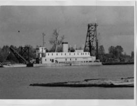
Photograph depicts the Public Works Department dredger (suction) at work in the north arm of the Fraser River, near Boundary River, in Vancouver.
Photograph depicts a wooden truss bridge in north Washington, probably somewhere east of Everett.
Photograph depicts bridge crossing over the Campbell River, 1 mile west of downtown Campbell River.
Photograph depicts the road and rail bridges at New Westminster, BCView is from the north and facing upstream.
Photograph depicts a home at 673 Selby St. in Nanaimo, B.C. on Vancouver, Island.
Photograph depicts the Canadian Bank of Commerce in Ladysmith, B.C. on Vancouver Island. Building is estimated to be built between 1901-1905.
Photograph depicts the office of the Central Coal Co. Ltd., located on the south outskirts of Nanaimo, B.C. beside the Esquimalt and Nanaimo Railway. The building is one of the last pieces of evidence of coal distribution in Nanaimo.
Photograph depicts a church in Arrow Park on Arrow Lakes in southeastern B.C.
Photograph depicts a derelict but genuine log cabin beside the lower Arrow Lake near Fauquier, B.C.
Photograph taken at the Duncan Forestry Museum.
Photograph depicts a wooden bridge over the Salmon River near Sayward, near Kelsey Bay, North Vancouver Island.
Photograph depicts a road trestle bridge for cars about halfway between south Wellington and Nanaimo Lake, southwest of Nanaimo.
Photograph depicts a derelict building in Ladysmith on Vancouver Island built approximately between 1900 and 1905.
Photograph depicts St. Anne's log church on French Creek, near Parksville on Vancouver Island. The church was built in 1894 and was still in use at the time.
Photograph depicts a bandstand at English Bay in Vancouver, B.C.
Photograph depicts a car parked on the road between Kaslo and New Denver, on the site of a former railway right-of-way.
Photograph depicts a bear at the garbage dump of the Gold River logging camp. Five other bears have retreated to the fire weed and blackened tree stumps.
Photograph depicts a view looking northwest at Osoyoos Lake, B.C.
Photograph depicts Tofino on Vancouver Island. View taken from wharf with a lifeboat on slip.
Photograph depicts a house fire possibly on 1000 Beach Block and Thurlow St. , caused by a wrecking gang.
Photograph depicts a field being cleared near Miracle Beach, 20 minutes south of Campbell River, on Vancouver Island.
Photograph depicts land clearance between Monashee Pass and Lumby, B.C.
Photograph depicts telephone fittings on Vancouver Island.
Photograph depicts a small coal tram at Tsable coal pit near Fanny Bay on Vancouver Island.
Photograph depicts a log boom probably in the Lower Mainland or on Vancouver Island.
Photograph depicts dumping logs at Gold River on the west coast of Vancouver Island.
Photograph depicts a baby seal at C.N. log drop at Cowichan Lake on Vancouver Island.
Photograph depicts a logging museum in Ladysmith on Vancouver Island.
Photograph depicts a mineral ore (lead or zinc?) mines near the ghost town of Sandon, on the road between Kaslo and New Denver.
Photograph depicts an early internal combustion tractor at Greenwood, BC
Photograph depicts Belmont Park Fort on the west side of Esquimalt Harbour. It was built by the British Royal Engineers in 1895 to protect the naval base. Photo shows the lower fort with 2 gun emplacements.
Photograph depicts the entrance to the magazine feeding gun emplacement in the lower fort of Belmont Park Fort in Esquimalt Harbour.
Photograph depicts one of the 2 gun emplacements in the lower fort of Belmont Park Fort protecting Esquimalt Harbour.
Photograph depicts the one and only gun emplacement in the upper fort of Belmont Park Fort protecting Esquimalt Harbour.
Photograph depicts one of the few surviving hand operated gas pumps, halfway between Campbell River and Kelsey Bay, BCWithin three months this gas station will have electricity.
Photograph depicts a southbound C.P.R. streamliner at the Mud Bay crossing on Vancouver Island. This part of track belongs to the Esquimalt and Nanaimo Railway, and the crossing is being re-sited.
Photograph depicts a train at the Great Northern Railway Station in Vancouver, B.C.
Photograph depicts a train car backing up on the west side of the C.N. station in Hope. It is part of the West Coast Railway Association trip on August 8, 1964.
Photograph depicts one of the two open C.P.R. cars located at Vancouver included in the West Coast Railway Association special trip from Vancouver to Hope. The cars stopped at Sumas Bridge for a photo halt.
Photograph depicts the Courtenay terminus of the Esquimalt and Nanaimo Railway. The view is looking north.
Photograph depicts the Malahat station on the Esquimalt and Nanaimo Railway line, 20 miles north of Victoria on Vancouver Island. The view is looking south and there are no houses anywhere in the vicinity.
Photograph depicts the Nanaimo passenger depot of the Esquimalt and Nanaimo Railway (at right) and the E & N freight shed (at left).
Photograph depicts the junction station of the Esquimalt and Nanaimo Railway at Parksville on Vancouver Island. The view is looking south.
Photograph depicts yard signals of the MacMillan Bloedel & Powell River Logging Railway, primarily protecting the Comox Logging & Railway Company crossing. The Esquimalt and Nanaimo Railway is about 300 yards to the north. Crossing is near Ladysmith. It is most unusual to find signal in B.C. at this point.
Photograph depicts the service car of the Esquimalt and Nanaimo Railway in front of the E & N freight shed. The Nanaimo passenger depot (not depicted) is located behind the photographer.
Photograph depicts the rear view of two C.P.R. snowplows in the Coquitlam yards. The one in the forefront is #400790.
Photograph depicts the front view of two snow plows at the C.P.R. Coquitlam yards.
Photograph depicts a mechanical side cutting machine at the C.P.R. Coquitlam yards.
Photograph depicts a boxcar at the C.P.R. Coquitlam yards. Note the frame construction.
Photograph depicts the Malahat Station on the Esquimalt and Nanaimo Railway on Vancouver Island. The view is looking south towards Victoria.