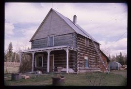
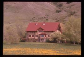
File consists of notes, clippings, and reproductions relating to South Fort George. Includes: "South Fort George - A trip to the past" heritage brochure produced by South Fort George Community Association (1987) and "B.C. Express Co. Heritage Site" typed document prepared by the Heritage Advisory Committee (Feb. 1994). Also includes photographs depicting various buildings from old South Fort George.
The item is a photograph depicting the back of a four-level stucco house in South Fort George. Various appliances are being kept by the house. The house is likely located in the Hazelton Street area, Prince George.
The item is a photograph depicting the front and side of the house located at 2542 Hazelton Street, Prince George. The stucco house has three levels and multiple units.
The item is an annotated photograph depicting the Prince George airport terminal. The photograph labels the RCMP, airport terminal and small arms buildings. Photograph taken prior to fire.
The item is a photograph depicting a residential duplex house off the Cariboo Highway.
The item is a 35 mm slide photograph depicting a residential duplex house off the Cariboo Highway. It is one of three buildings that were relocated for the airport in 1957.
The item is a 35 mm photograph depicting a workshop in the rural Prince George area.
The item is a 35 mm photograph depicting a stucco duplex on the Cariboo Highway.
File consists of photographs depicting Soda Creek Cemetery and presumably the general Soda Creek area. Also includes photographs of a personal residence and Kent Sedgwick with a dog.
Photograph depicts the graves of Seward Rankin, Gerald Rankin, and James Rankin at the Soda Creek Cemetery.
Photograph depicts Celia M Dusseau's grave stone in the Soda Creek Cemetery.
Photograph depicting a dirt road winding between grass and trees in Soda Creek.
Photograph depicting an abandoned building in Soda Creek, the building surrounded by overgrown grass and trees.
Photograph depicting a garden and backyard in someone's personal residence.
Photograph depicting Kent Sedgwick and a dog in someone's garden and personal residence.
Image depicts a log house at an uncertain location.
Image depicts an old barn located somewhere near Dunlevy Creek in the Dawson Creek area.
Image depicts an old barn located at a dairy farm somewhere near Dunlevy Creek in the Dawson Creek area.
The item is a photograph depicting a house with a blue car at 1705 Fir Street, Prince George. Annotation on the back of the photograph states, "1705 Fir St. - N. of F-C school at 17th."
The item is a photograph depicting the exterior of old damaged buildings on the Moffat farmland. There is a fence at the entrance to the driveway with an address sign that reads "1820."
The item is a photograph depicting the exterior of old damaged house on the Moffat farmland. There is a broken fence at the rear of the house, broken windows and a collapsed roof.
The item is a photograph depicting the exterior of old stable on the Moffat farmland.
File consists of notes and reproductions relating to the Prince George Secondary School (formerly Baron Byng High School and Prince George High School).
This item is a photograph of 575 Quebec Street, Prince George. Building is white, pink and blue. Telus tower can be seen in the background.
Blue and white building in downtown Prince George.
This item is a photograph of the Fane Building in downtown Prince George. "For Lease Office Space" sign in one of the windows.
This item is a photograph of the Fane Building in downtown Prince George.
This item is a photograph of a yellow parkade in downtown Prince George. Liquidation World can be seen in the background.
This item is a photograph of Frameworks Gallery and National Til'den Car & Truck Sales in downtown Prince George. Telus building can be seen in the background. Annotation on back states, "demo 2007 for gaming centre."
This item is a 35 mm photograph negative of the Highway 16 bridge over the Fraser River. Photograph was taken in the fall.
This item is a 35 mm photograph negative of the Nechako River, Prince George. Water level is very low.
The Lieutenant Governor stands next to bridge and highway at top of image, cliffs and white water rapids visible below.
File consists of notes, clippings, and reproductions relating to the King George V Elementary School in Prince George. Includes: "RE: Heritage Designation of KGV School" typed letter from George Paul, City Manager to Secretary of the Heritage Commission (21 Apr. 1997). File also includes photographs depicting the exterior of the King George V school prior to its demolition (2005).
File consists of photographs depicting various buildings in downtown Prince George and the Fraser River taken by Trelle Morrow.
This item is a photograph of 575 Quebec Street, Prince George. Building is white, pink and blue. Telus tower can be seen in the background.
This item is a photograph of the Fane Building in downtown Prince George. The Telus building can be seen in the background.
This item is a photograph of Dr. D. G. Wheatcroft Chiropractors, Happy Scrappers and the Law Office of Brian Gilson, George Leven, and Jason LeBlond.
This item is a photograph of the Freemason building at 480 Vancouver Street, Prince George.
This item is a 35 mm photograph negative of the Nechako River, Prince George. Water level is very low.
Photograph depicts an open grassy field surrounded by trees in Soda Creek.
Photograph depicting a garden and backyard in someone's personal residence.
Photograph depicting a dog laying in the grass in someone's backyard of a personal residence.
The item is a photograph depicting the exterior of old stable on the Moffat farmland.
Image depicts the Alkali Lake Ranch in Akali Lake, B.C.
Image depicts a shed in an unknown location.
Image depicts the old community hall in Soda Creek, B.C.
Image depicts a house in Soda Creek, B.C.
Image depicts the old BX Sternwheeler office building in Soda Creek, B.C.