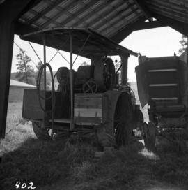
Photograph depicts a traction engine at a ranch on Nicola Lake, near Merritt. The engine was made by Nichols-Shepard Co. at Battle Creek, Michigan and named the "Red River Special." It is undated and has 2 cylinders, side tanks, 16-10 horse power, wood burner, firebox 5 ft. long.
Photograph depicts an abandoned coal mine in Coal Creek, 5 miles east of Fernie, BCThe entrance to the mine is unusual and is 2/3rds up the mountainside. The mine was closed in 1959. Flat ground in foreground is littered with at least 100 mine tubs of approximately 3'0' gauge.
Photograph depicts a grave in the churchyard of Murray Church in Nicola, near Merritt. The church was built in 1876, which makes it one of the oldest churches in the interior of B.C. The gravestone shows a death in 1882, of a son aged 14.
Photograph depicts the mine buildings of the mine at Coal Creek that closed in 1959. The newer buildings date to circa 1930. Much of the standard gauge trackage of Morrissey, Fernie, and Michel railway (subsidiary of the Great Northern Railway) in mine area remains. The track between Coal Creek and Fernie has not been lifted.
Photograph depicts a truck at the Teepoortens Truck and Equipment Rentals Ltd., located at 950 West 6th Ave. in Vancouver, BC
Photograph depicts a horse drawn wagon at Kingbaker Creek on the southeast end of Mara Lake, south of Sicamous on highway 97A.
Photograph depicts one of the three remaining fire hydrants on location of the former Chinatown in Nanaimo, BCIt was provided and installed by the Chinese and not the city of Nanaimo. The hydrant had no identification marks.
Photograph depicts a rear view of 4 of the 6 traction engines in Nanton, Alberta. The left engine was built by Reeves and Co. in Columbus, Indiana, U.S. Its identification is #4438, it has 2 cylinder simple, and a roof. The next engine was built by Waterloo Mfg. Co. Ltd. in Waterloo, Ontario and has a single cylinder. The third engine was built by Sawyer Massey. The engine on the right side is a Gaar Scott, built in 1913, and has 25 horsepower on the drawbar and 75 horsepower on the belt.
Photograph depicts the C.P.R. terminal in Vancouver. A C.P.R. switcher is collecting cars from the "Princess of Vancouver" at about 7 p.m.
Photograph depicts the C.P.R. station at Golden, B.C. The view is looking east.
Photograph depicts the C.P.R. station at Merritt, halfway between Spences Bridge and Brockmere Junction. The line is in active use.
Photograph depicts the C.P.R. westbound freight train at passing loop at Illecillewaet, between Rogers Pass and Revelstoke. The April 25, 1965 CPR Employee timetable lists the mileage at Illecillewaet as 98.2 with a siding capacity of 85 cars.
Photograph depicts the C.P.R. yards on Cambie St. in Vancouver, B.C. The view is looking west with False Creek on the left (out of the picture), after a snowfall.
Photograph depicts the unused C.P.R. Shawnigan Lake section house on the Esquimalt and Nanaimo Railway. It is 27.8 miles outside Victoria.
Photograph depicts a C.P.R. wrecking crane at the Vancouver station.
Photograph depicts a coach stock in the C.P.R. False Creek yards in Vancouver, B.C.
Photograph depicts the C.P.R. ferry slip at Kaslo on Kootenay Lake. It is in regular use.
Photograph depicts a C.P.R. barge on Slocan Lake, travelling north just after leaving Slocan. It holds a complete train including a locomotive, eight cars, and a caboose.
Photograph depicts equipment on a rail line.
Photograph depicts a tower controlling the C.P.R. grade crossing at Alexander St. in Vancouver, B.C.
Photograph depicts the C.P.R. engineering shops at Revelstoke. The view is looking north, with the line from Arrowhead behind the camera.
Photograph depicts a view looking northeast of the B.C. Electric Railway from the abandoned Sumas substation at Vedder Mountain.
Photograph depicts the north end of the False Creek trestle, looking east towards the C.P.R. yards in Vancouver.
Photograph depicts the B.C. Electric Railway crossing 3rd Ave. with the first intersection at the immediate left. Note the abandoned double trackage at left. The view is looking north.
Photograph depicts the B.C. Electric Railway in Langley, looking northeast from town grade crossing.
Photograph depicts the B.C. Electric Railway crossing on Main St. in Langley, looking southwest.
Photograph depicts a B.C. Electric Railway trolley electric locomotive #960, in freight yard below the Georgia Viaduct in Vancouver.
Photograph depicts special equipment opposite a car barn of the B.C. Electric Railway, at New Westminster.
Photograph depicts car #1223 on display in south Burnaby beside the RCMP headquarters in Kingsway and Edmonds St., on site of the former track.
Photograph depicts the abandoned Sumas substation at Vedder Mountain.
Photograph depicts a locomotive shed at Chilliwack. Note the electric conductor wire guard at the point where the doors meet at their tops.
Photograph depicts a derelict substation on the B.C. Electric Railway at Coghlan, 9 rail miles east of Langley. Though marked "Langley", the building is sited as stated.
Photograph depicts the Canadian National Railway (CN) repair shops at Port Mann. The caboose is receiving a spray paint job.
Photograph depicts the Canadian National Railway (CN) Chilliwack depot, looking north.
Photograph depicts the track transfer transporter at the Canadian National Railway (CN) repair shops at Port Mann.
Photograph depicts the Canadian National Railway (CN) station at Clearwater, on the mainline between Kamloops and Tete Juane Cache Junction, about 75 miles north of Kamloops. The main trade is lumber. The view is looking south.
Photograph depicts the Canadian National Railway (CN) train crossing Powell St. and the C.P.R. tracks to get to North Vancouver.
Photograph depicts the Canadian National Railway (CN) line at Deerholme Junction, near Duncan, on Vancouver Island. The wrecking train on siding is ready for emergencies.
Photograph depicts a Canadian National Railway (CN) special purpose car at Port Mann repair shop. It is fitted with a winch inside.
Photograph depicts the Great Northern Railway former station at Cascade, just north of the Canada-U.S. border and 15 miles east of Grand Forks. The line connects Kettle Falls and Grand Forks, but the station is now disused but in good repair. The view is looking south towards Washington State.
Photograph depicts the ongoing wrecking of house #1053 on Beach Ave.
Photograph depicts the homes on 1000 Beach Ave. in Vancouver, B.C.
Photograph depicts the city hall at New Westminster on Victoria Day. The anvil battery is about to fire a 21 gun salute.
Photograph depicts the city hall at New Westminster on Victoria Day. The anvil battery firing round #3 of 21 gun salute.
Photograph depicts Granite Falls near the Wigwam Inn, Indian Arm, Vancouver, B.C.
Photograph depicts Granite Falls and wharf at Indian Arm, looking west from the top of the falls.
Photograph depicts the Vancouver Shipyards Ltd. on 555 Denman St. in Vancouver, B.C., looking south from Coal Harbour waters.
Photograph depicts the west end of Coal Harbour looking south to West Georgia St. and Chilco-Gilford block beyond. The old pilings exposed at low tide.
Photograph depicts the site of a new deep water ship wharf with Centennial Pier in the background, looking east. Left of the wall is the sea and the right side will be dirt filled.