Print preview Close

Showing 2440 results

Archival description
2097 results with digital objects Show results with digital objects
Writing on a Rock
2012.13.1.56.73 · Item · 1973
Part of J. Kent Sedgwick fonds

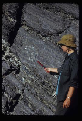
Image depicts an unknown individual pointing at some writing on a rock; it possibly reads "ACC Aug 10 1911."

Boat Launch
2012.13.1.60.17 · Item · July 1973
Part of J. Kent Sedgwick fonds

Image depicts a boat launch with several people nearby; it is possibly at War Lake in Carp Lake Provincial Park.

Nechako River?
2012.13.1.23.08 · Item · 1973
Part of J. Kent Sedgwick fonds

Image depicts what is possibly a small section of the Nechako River on Cottonwood Island.

Mackenzie - Morfee Lake
2012.13.1.70.07 · Item · 1973
Part of J. Kent Sedgwick fonds

Image depicts the frozen Morfee Lake just to the East of Mackenzie, B.C. The slide is also labelled "sub-boreal," referencing that it is a sub-boreal spruce zone.

Upper Fraser Road in Winter
2012.13.1.89.016 · Item · Feb. 1973
Part of J. Kent Sedgwick fonds

Image depicts several unidentified individuals walking along the snow-covered Upper Fraser Road with numerous buildings on either side. Map coordinates 54°07'05.7"N 121°56'38.9"W

Nautley Site
2012.13.1.51.030 · Item · May 1973
Part of J. Kent Sedgwick fonds

Image depicts an old, collapsing house at the Nautley site in Fort Fraser, B.C.

Stewart Access Road
2012.13.1.51.036 · Item · May 1973
Part of J. Kent Sedgwick fonds

Image depicts a man, possibly Kent Sedgwick, leaning against a sign forbidding public traffic on the Stewart Access Road from between 5 am to 8 pm. Located in Hazelton, B.C.

A Man and River
2012.13.1.56.04 · Item · 1973
Part of J. Kent Sedgwick fonds

Image depicts a man on the hiking trail near Mt. Robson, with a river in the background; it is possibly the Robson River.