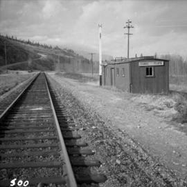
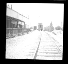
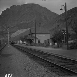
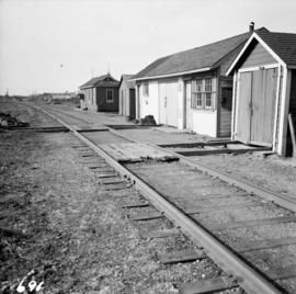
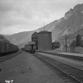
Photograph depicts the C.P.R. station at Spences Bridge. The view is looking south at a departing freight train.
File consists of documentary photographs taken by David Davies of public railways, mainly belonging to the Canadian Pacific Railway in British Columbia.
Photograph depicts the C.P.R. depot at Canal Flats on the Golden-Cranbrook line. The ex box car depot now is used only to make line phone calls.
Photograph depicts the Canadian National Railway (CN) freight depot at Penticton, with a motor/rail tractor in the photo.
Photograph depicts the Sun Building at the intersection of Beatty and West Pender St. in Vancouver, B.C. The photo was taken after the Pacific Press Ltd. Vacated the building on December 26, 1965, and the "Sun" neon sign on the tower was removed. The view is looking west from West Pender St.
Photograph depicts a shop on the north side of Main St. in Cumberland on Vancouver, Island.
Photograph depicts the derelict CPR depot at Hope, part of the former Kettle Valley line. A spur of about 3 miles still exists between the Odlum junction with the main line on the north side of the Fraser River and this depot, and continues southeast to a point near the CNR. It is not abandoned, but little used. The Hope yard has a 47 car capacity.
Photograph depicts the CPR line at Osoyoos at the BC Tree Fruits Ltd. warehouse and spur. This is about 1 mile north of the depot. The daily freight train from Penticton is returning from Osoyoos, having just collected 1 boxcar of fruit, backing onto caboose. This is approximately at mile 35.4 from Penticton.
Photograph depicts a courthouse in Richfield, 1 mile above Barkerville. It was the only building left standing of the former mining community.
Photograph depicts a church that was built of shaped logs on the territory of the Tsal'alh Nation on the road leading to Seton Lake. Church was derelict, but still held pews, plastic flowers and small shrines.
Photograph depicts "Butterchurch" that was built in 1870 under the direction of Father Rondeault of the Oblate Order for missionary work among the Comiakan Natives, a tribe of about 100. It was abandoned by about 1880 because of its location. It was recently restored as a historical shrine.
Photograph depicts a completely rebuilt saloon that was done so based on historical sketches and photos.
Photograph depicts a log cabin that was inhabited by an older aboriginal man who is visible in the window. The cabin was perhaps 100 years old.
Photograph depicts a courthouse on Howe St. in Vancouver, B.C. There are paintings on the fence surrounding the forecourt.
Photograph depicts a swimming pool at Second Beach in Stanley Park, Vancouver, B.C. The snow in the foreground is 16 inches deep and there is a gathering snowstorm in the background coming in from the west.
Photograph depicts a view of the Fraser River from the Albion Ferry from Haney to Fort Langley. The ferry is approaching the south bank of Fort Langley. Gulls sat on logs floating downstream; too heavy to rise after eating candlefish.
Photograph depicts the fire hall at Lillooet, including an old hand drawn hose reel carrier.
Photograph depicts the end of the old Coal Harbour extension of the C.P.R. line from Vancouver. It was disused for several years. The view is looking east with Woodward's Marina behind.
Photograph depicts the Canadian National Railway (CN) depot at Spences Bridge, from a view looking southwest.
Photograph depicts the Canadian National Railway (CN) depot in Vernon, which is no longer used for passenger traffic.
Photograph depicts Canadian National Railway (CN) track crew sheds on Lulu Island at the south end of the Fraser St. road-vehicle bridge, near the intersection of #5 Rd. and Vulcan Way. The track is well used. The view is looking west.
File consists of documentary photographs taken by David Davies of buildings in British Columbia.
Photograph depicts the C.P.R. pier A.1. (now 12A) at Vancouver, B.C., slightly right of the foot of Thurlow St. It was built in 1890 and it is still in use. The view shows its east face.
Photograph depicts the seaward end of C.P.R. pier A1 (now 12A), showing its rotted condition. The pier was built in 1890 and is still in use except at this outer face. C.P.R. pier B1 is in the background.
Photograph depicts the church of His Presence in Halfmoon Bay, Sechelt. It was built in 1962 by Cannon Greene, a former seafaring minister of the Columbia Coast Missions and the subject of a C.B.C. T.V. production in early April 1966.
Photograph depicts St. Hilda's Anglican Church in Sechelt on the Sechelt Peninsula. Tall tree on left just coming into flower is a dogwood.
Photograph depicts one of the few surviving old style garages in west end Vancouver on Barclay St.
Photograph depicts a house on Nicola St. at the southwest corner of the intersection of Nicola and Robson St., in Vancouver, B.C.
Photograph depicts a fisherman's house, lived in and owned by a First Nations man (?), on the south bank of the south arm of the Fraser River. It is about 5 miles southeast of New Westminster at approximately 9000 block of River Road.
Photograph depicts the junction of Robson and Cordero St. in west end Vancouver, B.C. The photo is looking northwest on the newly demolished block, except for some houses at far end. View is looking down Robson St., with Cordero St. intersecting the photo.
Photograph depicts the United Church at Spences Bridge in the Fraser Canyon. The church is on the flats on the west side of the river and close to the C.N. depot.
Photograph depicts a log barn at Lookout Lodge beside Shuswap Lake, between Sorrento and Squilex.
Photograph depicts the Westbridge CPR depot on the Kettle Valley Line. It is located about 11 miles north of Rock Creek and at about mile 123.3 east of Penticton. The depot house is disused and the sidings contained no cars, so there appears to be no local traffic.
Photograph depicts a former fire hall that was now preserved.
Photograph depicts British Navy cottages (styled after cottages in the U.K.) in Esquimalt. Built when Dockyard was operated by the Imperial Navy.
Photograph depicts a bell tower of a Roman Catholic church in the Saanich Peninsula.
Photograph depicts Hat Creek Staging Hotel, 7 miles north of Cache Creek. The hotel buildig were now part of a farm and contained stores, a cookehouse, and a dormitory.
Photograph taken at Okangan Lake, on Alexis Beach. O'Keefe Ranch is located at the head of the lake. Visible is an old house that was used as a hay barn.
Photograph depicts a barn at Port Guichon, 1 mile west of Ladner, Delta.
Photograph depicts the Delta Municipal Hall on Main St. in Ladner, B.C.
Photograph depicts a disused schoolhouse with the dates "1925" and "1902" on it. It is on River Rd. on the south bank of the Fraser River in Delta, opposite the west end of Annacis Island.
Photograph depicts Alberni St. in the west end of Vancouver. It is directly opposite the Vehicle Testing Station, in the 1700 block. The view in the photo is looking east.
Photograph depicts a courthouse in Vancouver, B.C. surrounded by a fence with paintings.
Photograph depicts a painting on a fence outside a courthouse on Howe St. in Vancouver, B.C. The painting shows the natural grandeur of B.C. partially blocked out by a super motel with a bewildered moose forced to become an ornamental fountain. The whole forecourt is being bulldozed to make way for the Centennial fountain.
Photograph depicts a wharf at Sechelt village on the Sechelt Peninsula. The view is looking southeast towards Vancouver.
Photograph depicts the general view of the waterfront buildings between Burrard and Thurlow St., in Vancouver Harbour looking northwest from Burrard St. The Immigration Building is on the left and the "Princess of Vancouver" (C.P.R.) is in the middle distance.
Photograph depicts a view of downtown Vancouver taken from the east end of False Creek at the foot of Terminal Ave. The view is looking northwest. In the middle distance on the left is the pier of a railway bridge taking the Great Northern Railway line into the city. It was demolished in about 1915-1920 when a new Great Northern station was constructed.
Photograph depicts Lund Harbour, looking north, 12 miles north of Powell River. It is the most northerly point on the mainland accessible by car, on this part of the coast. Lund is 92 car miles north of the ferry terminal at Langdale.
Photograph depicts the north bank of False Creek in Vancouver, B.C. The photograph was taken from the Cambie Bridge, with a view looking west.
Photograph depicts a C.P.R. way-freight at the disused Wellington Depot on the Esquimalt and Nanaimo Railway, 4 miles north of Nanaimo.