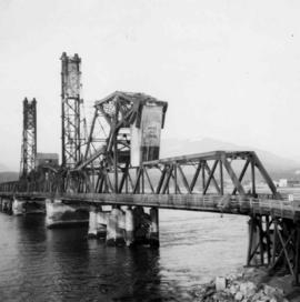
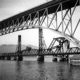
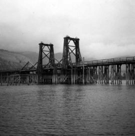
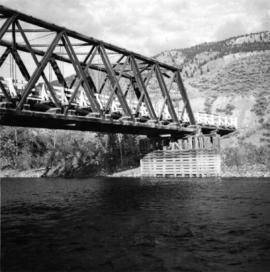
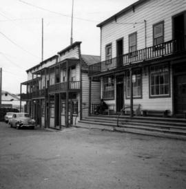
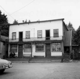
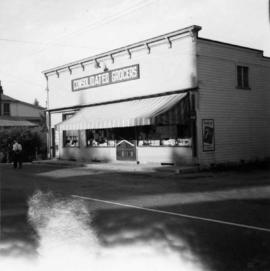
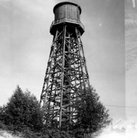
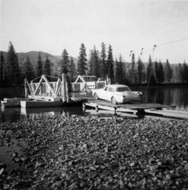
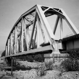
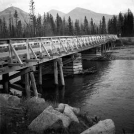
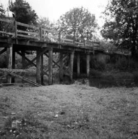
Photograph depicts a wooden bridge crossing a stream on the north side of Vedder Mountain near Belrose.
Photograph depicts the Second Narrows railway bridge in Vancouver, BC
Photograph depicts the Fraser St. road bridge over the north section of the north arm of the Fraser River (ie. between Vancouver and Mitchell Island). Shot is looking northeast.
Photograph depicts an old wooden lifting span bridge (now rigid) over the east Thompson River at Pritchard, 25 miles east of Kamloops. View is looking northeast. The bridge was built for sternwheeler traffic.
Photograph depicts a Pacific Great Eastern rail bridge to crossing the Capilano River in west Vancouver. Photo is taken from the east shore looking west.
Photograph depicts the Cambie St. Bridge in Vancouver, BC, looking east and showing the north fixed span of the bridge.
Photograph depicts the rail connections below the north bank of the Patullo Bridge in New Westminster. The track in the foreground belongs to C.N. and the flyover foreground rail bridge belongs to the B.C. Electric Railway. The flyover background rail bridge is shared by the Great Northern Rail and C.N. Rail.
Photograph depicts the railway bridge at New Westminster, looking towards the south bank. The bridge is used by C.N., BCHydro, and the Great Northern Railway.
Photograph depicts the road bridge over Toby Creek, just north of Invermere or 75 miles north of Cranbrook, looking at upstream piers.
Photograph depicts the bridge over the Nicola River at Spences Bridge in the north Fraser Canyon, looking downstream.
Photograph depicts what is believed to be the only remaining "summer cottage" on Beach Ave. in English Bay.
Photograph depicts a barn advertised for rent on Liverpool Rd. in South Westminster. Barn later half demolished on April 17, 1966.
Photograph depicts an old house on 148th St. in north Surrey, about half a mile southwest of the south end of the Port Mann Bridge.
Photograph depicts a former Sailor's Home at the southeast corner of the intersection at Alexander St. and Jackson St. in Vancouver, B.C.
Photograph depicts the former "Terminus Hotel" on 32 Water St., 50 yards from the center of old Vancouver.
Photograph depicts the Mussenden Building used by the Hudson's Bay Company. It is located on Water St. in Vancouver, B.C. View is from the north side looking east.
Photograph depicts an old church or school being demolished at 1701-1721 West 3rd Ave. (and Pine), in Vancouver, B.C.
Photograph depicts a stone house on 17th St. and Esquimalt St. in West Vancouver, B.C.
Photograph depicts the Wheatsheaf Inn "pub" on the way to Cedar-by-the-Sea from Nanaimo, B.C.
Photograph depicts Chinatown in Duncan, B.C. on Vancouver Island.
Photograph depicts the Chinatown in Duncan on Vancouver Island.
Photograph depicts a grocery store on the main street of Pitt Meadows in the Fraser Valley.
Photograph depicts the water tower at B.C. Forest Products Ltd. Mill at Port Hammond, in the Fraser Valley.
Photograph depicts the corner building on West Georgia and Chilco St., facing Stanley Park in Vancouver B.C. View looking south across Georgia St.
Photograph depicts a church or school on the south side of Craigflower Rd. in Victoria B.C. It is near or on the Songhees Reserve.
Photograph depicts a former hotel, 300 yards from the former government wharf, in Squamish, B.C.
Photograph depicts an implement shed at Cloverdale in the Fraser Valley on the Pacific Highway.
Photograph depicts a disused general store at Coghlan, 5 miles southeast of Fort Langley in the Fraser Valley.
Photograph depicts the Windsor Hotel at Fort Steele, 10 miles northeast of Cranbrook. It was built in 1895 by Robert D. Mather and originally was called Dalgarno House. It is being renovated as a village museum.
Photograph depicts a general view of Coal Harbour in Vancouver, taken from its head in Stanley Park, looking east. The Bayshore Inn is shown on the extreme left of the image.
Photograph depicts an empty site at 1000 Beach Ave. in Vancouver, B.C.
Photograph depicts a view of Indian Arm, looking south from Granite Falls.
Photograph depicts the upper end of Coal Harbour, on the south shore looking southwest and taken from the dock of the Vancouver Shipyards Ltd.
Photograph depicts a view looking northeast towards Coal Harbour from Alberni St. (Chilco-Gilford block) with West Georgia St. in the middle distance.
Photograph depicts a general view of Coal Harbour in Vancouver, looking southeast and taken from Royal Vancouver Yacht Club premises. Photo shows the Bayshore Hotel on the extreme left.
Photograph depicts the construction of a new deep sea wharf on the site of an old Hastings mill in Vancouver, B.C. The forepart is to be dirt filled. The view is looking northeast.
Photograph depicts bollards for erection in new sea wall, to make outer face of the deep sea wharf being constructed at Dunlevey St. in Vancouver, B.C.
Photograph depicts the sluice gates off the Nicola River, on a ranch at Nicola village, 7 miles northeast of Merritt.
Photograph depicts a reaction ferry at Blackpool, near Clearwater on the north Thompson River, about 60 miles north of Kamloops. The car is being loaded on the east bank.
Photograph depicts the north shore of False Creek, looking west after a snowfall. Photo taken from the swing span of Cambie Bridge in Vancouver, B.C.
Photograph depicts an early spool donkey at the Cowichan Valley Forest Museum
Photograph depicts a scow with chips landing on the north shore of Vancouver harbour. There are Saskatchewan wheat elevators in the background.
Photograph depicts a general view of a Horne Bros. Ltd. shingle mill on #305 West Esplanade Rd. in North Vancouver.
Photograph depicts a view of the booming ground of the Horne Bros. Shingle Co. Ltd. On #305 West Esplanade Rd. in North Vancouver.
Photograph depicts an oxen powered log carrier with wheels that are approximately 10 feet in diameter. It is at Pioneer Park and Museum near Totem Lake, 3 miles north of Yahk and 30 miles east of Creston.
Photograph depicts a mine car at Moyie mine, at Moyie, 20 miles south of Cranbrook. The mine produced silver, zinc, and lead, and worked principally from 1900-1910. It is now disused.
Photograph depicts a horse drawn wagon in a garden at New Denver, Slocan Lake.
Photograph depicts a recently used steam crane, but driven by compressed air, at a former quarry at Granite Falls on the northeast end of the Indian Arm. The timbers on of the cabin were thick to withstand the blasting rock falls.
Photograph depicts a C.P.R. steam driven tracked crane at Revelstoke, BCIt was only marked "C.P. Service E.I."