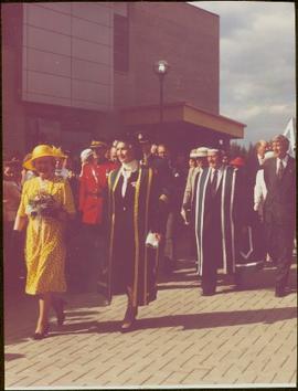
Affichage de 434 résultats

Archival description
434 résultats avec objets numériques Afficher les résultats avec des objets numériques
2008.3.3.3.22 · Pièce · 26 May 1995
Fait partie de Bridget Moran fonds

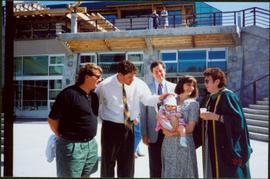
Photograph depicts Moran wearing regalia, standing to right of family members in the Agora courtyard at the University of Northern British Columbia in Prince George, B.C. Sons Mike (wearing black) and Pat stand on left, and Paul Ramsey stands in center. Unidentified individuals stand near Winter Garden in background. Photo taken on the day Moran received an Honourary Law Degree.

Outside Spee-Dee Printers
2012.13.1.128.04 · Pièce · 1994
Fait partie de J. Kent Sedgwick fonds

Image depicts a group of individuals on the sidewalk outside Spee-Dee Printers on Brunswick Street in Prince George, B.C.

Woman in the Street
2012.13.1.128.06 · Pièce · 1994
Fait partie de J. Kent Sedgwick fonds

Image depicts a woman, wearing clothes reminiscent of traditional First Nations, who appears to be dancing in the street outside of a Native Friendship Centre in Prince George, B.C. A large crowd is looking on.

2012.13.1.5.10 · Pièce · 6 Sept. 1993
Fait partie de J. Kent Sedgwick fonds

Image depicts two mills; the Intercontinental Pulp Mill is on the right in the foreground, and the Prince George Pulp and Paper Mill is on the left in the background. The picture is taken from the South, possibly off Yellowhead Bridge in Prince George, B.C.

Prince George Sign
2012.13.1.3.139 · Pièce · 6 Sept. 1993
Fait partie de J. Kent Sedgwick fonds

Image depicts the Prince George welcome and population sign, with a population of 71,086. Map coordinates 53°53'52.0"N 122°46'08.7"W

2012.13.1.3.110 · Pièce · 12 Oct. 1989
Fait partie de J. Kent Sedgwick fonds

Image depicts George St in downtown Prince George with City Hall in the background. Also visible are the Prince George Hotel, Ming's Inn Chinese Restaurant, Fraser Stationers Ltd., Weiner King food cart, and a movie theatre. Map coordinates 53°54'55.0"N 122°44'36.1"W

Pine Centre Mall
2012.13.1.3.111 · Pièce · 12 Oct. 1989
Fait partie de J. Kent Sedgwick fonds

Image depicts Pine Centre Mall in Prince George, B. C. Map coordinates 53°53'53.2"N 122°46'36.4"W

Yellowhead Bridge
2012.13.1.3.120 · Pièce · 12 Oct. 1989
Fait partie de J. Kent Sedgwick fonds

Image depicts the Yellowhead Bridge across the Fraser River. Map coordinates 53°54'45.2"N 122°43'27.9"W

Mr. P.G.
2012.13.1.3.122 · Pièce · 12 Oct. 1989
Fait partie de J. Kent Sedgwick fonds

Image depicts Mr. P.G. and the Tourism Information site at the intersection of Highway 16 and 97. Map coordinates 53°53'46.5"N 122°46'00.7"W

Experimental Farm
2012.13.1.3.129 · Pièce · 13 Aug. 1989
Fait partie de J. Kent Sedgwick fonds

Image depicts a view of an experimental farm, possibly taken from Tabor Mountain.

Prince George
2012.13.1.3.135 · Pièce · 12 Oct. 1989
Fait partie de J. Kent Sedgwick fonds

Image depicts Prince George, possibly with the Northwood Pulpmill in the background.

Salvation Army
2012.13.1.3.112 · Pièce · 12 Oct. 1989
Fait partie de J. Kent Sedgwick fonds

Image depicts the Salvation Army on Ospika Boulevard in Prince George, B.C. Map coordinates 53°55'02.6"N 122°47'41.6"W.

Central Street West
2012.13.1.3.115 · Pièce · 12 Oct. 1989
Fait partie de J. Kent Sedgwick fonds

Image depicts Central Street West, parallel to Highway 97 in Prince George, B.C. looking north. Shown: Prince George Motors and other car dealerships, Burger King, Grama's Inn, and the Spruceland Shopping Mall sign. Map coordinates 53°54'42.1"N 122°46'53.1"W

Foothills Bridge
2012.13.1.3.123 · Pièce · 12 Oct. 1989
Fait partie de J. Kent Sedgwick fonds

Image depicts the Foothills Bridge over the Nechako river on the Foothills Boulevard in Prince George, B.C. Map coordinates 53°56'52.5"N 122°48'59.9"W

Prince George
2012.13.1.3.133 · Pièce · 12 Oct. 1989
Fait partie de J. Kent Sedgwick fonds

Image depicts Prince George, possibly with the Northwood Pulpmill in the background.

Bridge
2012.13.1.7.164 · Pièce · 12 Oct. 1989
Fait partie de J. Kent Sedgwick fonds

Image depicts a bridge in Prince George, B.C.

Beehive Burner
2012.13.1.3.088 · Pièce · 12 Oct. 1989
Fait partie de J. Kent Sedgwick fonds

Image depicts a Beehive Burner along the Nechako on River Road. Map coordinates 53°55'34.1"N 122°44'58.0"W

Salvation Army
2012.13.1.3.114 · Pièce · 12 Oct. 1989
Fait partie de J. Kent Sedgwick fonds

Image depicts the Salvation Army on Ospika Boulevard in Prince George, B.C. Map coordinates 53°55'02.6"N 122°47'41.6"W

Lakeland Sawmill
2012.13.1.3.130 · Pièce · 12 Oct. 1989
Fait partie de J. Kent Sedgwick fonds

Image depicts the Lakeland Sawmill in Prince George, B.C, identified by the beehive burners; the one with white smoke belonged to Pas Lumber Co. which was bought out by Lakeland in 1987.

Beehive Burner
2012.13.1.3.089 · Pièce · 12 Oct. 1989
Fait partie de J. Kent Sedgwick fonds

Image depicts a Beehive Burner along the Nechako on River Road. Map coordinates 53°55'34.1"N 122°44'58.0"W.

Downtown Prince George Businesses
2012.13.1.3.107 · Pièce · 12 Oct. 1989
Fait partie de J. Kent Sedgwick fonds

Image depicts 4th Ave at Brunswick St. and the following businesses: Hart Drugs, The Yarn Barn, and Saveco. Map coordinates 53°54'59.9"N 122°44'52.9"W

Downtown Prince George Businesses
2012.13.1.3.108 · Pièce · 12 Oct. 1989
Fait partie de J. Kent Sedgwick fonds

Image depicts 4th Ave at Quebec St, showing the following businesses: The Yarn Barn, Golden Chalice Jewellers, Dandy Lines, Ultrasport, and Saveco. Map coordinates 53°54'58.6"N 122°44'47.5"W