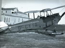
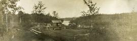
Showing 1199 results

Archival description
1070 results with digital objects Show results with digital objects
Drying sugar
2014.10.1.104 · Item · 1910
Part of Arthur Holland Land Surveying Collection

Photograph depicts a tarp spread out on the grass, two men sit nearby the tarp. There is a canvas tent in the background with a man standing beside it. Behind the tent is a low hill with a fence bordering the top of the hill. There are blankets drying on the fence.

Duke of Sutherland
2012.13.2.20.03 · File · 2011
Part of J. Kent Sedgwick fonds

File consists of notes and reproductions relating to the Duke of Sutherland. Also includes photographs depicting the area of White's Landing in Strathnaver (2010).

Duke of Sutherland
2012.13.2.20 · Subseries · 1980-2011
Part of J. Kent Sedgwick fonds

Subseries includes material collected by Kent Sedgwick regarding the Duke of Sutherland. The Duke of Sutherland is a title in the Peerage of the United Kingdom. The fourth Duke of Sutherland was Cromartie Sutherland-Leveson-Gower who lived from 1851 to 27 June 1913. Toward the end of his life, the 4th Duke began moving his wealth and life to Canada. The Duke owned land across British Columbia and Alberta and contributed to various settlements, including Strathnaver, BC; Windermere, BC; Brooks, AB; and Clyde, AB. The Duke of Sutherland owned the Sutherland Land Company, creating and selling plots in BC and Alberta. He also worked closely with the Canadian Pacific Railway to support immigration and settlement of the area.

2001.1.019 · File · 1934-1935
Part of NBCA Document and Ephemera Collection

File consists of eight newspaper clippings, seven of which are a series of articles on the findings of the Oxford University Ellesmere Land Expedition, with the eighth being a photograph of the Expedition’s winter quarters in Etah, Greenland. Five of the articles were written by the expedition leader, Mr. Noel Humphreys and the other two were written by members of the Expedition, Mr. Moore and Mr. Haig-Thomas. The articles were originally published in the “Times” of London but the clippings appear to be from the “New Zealand Herald”.

Humphreys, Noel
2021.06 · Collection · 1930-1932

Emil Bronlund was in 1927 hired by Consolidated Mining and Smelting Ltd. (later known as Cominco) to take on the company's mining exploration in northern British Columbia, a position he held for almost 25 years. Bronlund had a Leica camera and took photographs during his exploratory trips.

This album of Bronlund's photographic negatives from 1930 to 1932 includes photographs of the following trips:

  • Trip to Osilinka River and Omineca River, July 1930
  • Copper Mountain on Duck Creek, July 1930
  • Wedge Creek, Sept. 1930
  • Finlay River, Finlay Forks, Parsnip River, and Crooked River, Oct. 1930
  • Prince George, Aug. 1930
  • Gola, Norway, Apr. 1931
  • Emil Bronlund and Frank Swannell survey crews at Thutade Lake, June 1931 and Sept. 1931
  • Cairn mining claim exploration for Consolidated Mining and Smelting Ltd., June-July 1931
  • Brothers Lake, Bronlund Peak, and Fredricksen Lake, July 1932
  • Sustut Lake, Sept.-Oct 1931
  • McLeod River trip, Mar.-Apr. 1932
Bronlund, Emil
2012.13.2.02.50 · File · 2004-2011
Part of J. Kent Sedgwick fonds

File consists of notes, clippings, and reproductions relating to encouraging settlement and immigration to Prince George. Includes material on Dutch settlement in Prince George; the Hornby Plan, a 1933 settlement plan by the Canadian National Railway to develop communities and stimulate business for the railway, particularly in Prince George; promoting Prince George for settlers; reserved land for veterans; and auction of lands to cover delinquent taxes in British Columbia.

Father Adrien Morice
2012.13.2.10.06 · File · 2001
Part of J. Kent Sedgwick fonds

File consists of notes, clippings, and reproductions relating to Father Adrien Morice. Father Adrien Morice was a missionary and was ordained as a priest who came to British Columbia in 1880 to complete his ecclesiastical studies. After completing his schooling he was signed to the Williams Lake Mission where he worked closely with the Chilcotin peoples, learning their language and ministering. He continued to learn Chinook before moving to work at Stuart Lake with the Na'Kaztl'Tenneh Band in 1885, working with four divisions of the Carrier Tribes, the Alexandria, Quesnel, Blackwater, and Lhuskuz. Morice continued to use the Cree language and eventually published a monthly newspaper between 1881 and 1884 called "Tsettes Nahivelnik" (meaning "storyteller") using the Cree language. File primarily consists of handwritten notes by Kent Sedgwick regarding Father Adrien Morice and his work.

Felled Trees
2012.13.1.56.06 · Item · 1973
Part of J. Kent Sedgwick fonds

Image depicts a large number of felled trees, and an unknown individual standing on the path.

2014.10.1.179 · Item · 1911
Part of Arthur Holland Land Surveying Collection

Photograph depicts a cluster of buildings near Fraser Lake. A fence and grasses in the foreground. Original photo title: "Indian Village at Fraser Lake." First Nations communities with territories overlapping Fraser Lake include Nadleh Whut'en and Stellat'en Nations.

2009.7.1.248 · Item · ca. 1880-1920
Part of Archdeacon W. H. Collison fonds

Head on shot of steam engine traveling through a pass with mountains in the background. Handwritten annotation in pen on verso reads: "First Passenger Engine to reach Prince Rupert." Annotation on recto reads: "First Passenger Engine at Prince Rupert." Photographer' stamp in bottom right corner of recto reads : "Allen Photo."

Five boats breaking ice
2014.10.1.138 · Item · 1910
Part of Arthur Holland Land Surveying Collection

Photograph depicts five long canoes with several men attending. The canoes are traveling through a narrow strip of open water. The majority of the river is covered in ice. Forested trees are on the far river shore.

Five boats breaking ice
2014.10.1.139 · Item · 1910
Part of Arthur Holland Land Surveying Collection

Photograph depicts five long canoes with several men attending. The canoes are traveling through a narrow strip of open water. The majority of the river is covered in ice. Forested trees are on the far river shore.